J2Ski Snow Report - March 14th 2019
J2Ski Snow Report - March 14th 2019
Published : 14-Mar-2019 07:57
J2Ski Snow Report 14th March 2019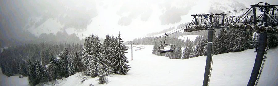
It's snowing in Les Gets, France, this morning... and many other French and Swiss ski areas too...
It's been a very snowy week for many places, and there's more on the way...
This Week's Snow Headlines - 14th March 2019
- California's Squaw Valley overtakes Switzerland's Andermatt for world's deepest snow base.
- Ski resorts in the Alps report up to a metre of snowfall since the weekend, more falling.
- Avalanche Risk Level back up to 3 (Considerable) in much of the Alps.
- Scottish ski areas re-open terrain as cold and snow follows Feb thaw.
It's been the snowiest week since the first half of January in the Alps with some ski areas in Switzerland posting a metre of snowfall already since the weekend, and if forecasts play out as expected, they may pass 1.5 metres (five feet) of new snow by next weekend.
The biggest snowfalls so far have been in Switzerland and Western Austria but the snow is covering a wide area and bases are expected to build fast in France and the Western Alps too as the week goes on.
It's not all powder though; strong winds have closed higher lifts at times, valley towns have had rain as well as snow and the avalanche risk level is heightened.
Elsewhere in Europe, there's been some snow at last in the Dolomites and Pyrenees after a fairly dry month and more up in Scandinavia, where it has been snowy all winter (apart from Finland).
It's been a week of storms and snowfall in Scotland with bases building fast on Scottish hills but, ironically, most of the centres that could now re-open, being kept closed by stormy weather rather than a lack of snow.
Across the Atlantic the latest heavy snowstorms saw resorts in California finally overtake Switzerland to post the world's deepest bases at over 6 metres/20 feet. Colorado hit maximum avalanche danger when more than a metre of snow fell in a few days there but the storm seems to have finally blown out and conditions, at last, are looking fairly calm and dry.
In the Alpine Forecast
Heavy snow expected for the next 48 hours, across a wide area of Austria, Switzerland and the northern French Alps. Scattered, lighter snowfalls and clearer conditions in the days to follow.
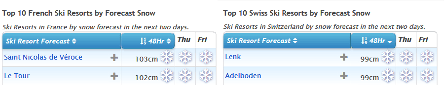
See where it's expected to snow this week...
Re-publication :- our Snow Report Summary, being the text above this line, is free to re-publish, but must be clearly credited to www.J2ski.com with text including "J2Ski Snow Report" linked to this page - thank you.
EUROPEAN ALPS
Austria
Austria saw a third successive week with fresh snowfall in parts of the country around the weekend. This time is was Galtur in the west of the country, close to the Swiss border, that posted the biggest snowfall numbers – 90cm in total through the past seven days.
But it has been snowy in much of the country and that looks to continue until the weekend when the snowfall should ease off. Thursday (today) and Friday look set to bring some big accumulations with several feet heading for the Arlberg and other ski areas in the West of the country – potentially the biggest snowfalls for several months.
The deepest snow (and the bases have grown a bit this past week after several weeks of thawing) are on the country's glaciers with the Dachstein topping the table with 4.9 metres lying up there.
France
French ski areas have had a snowy week and it looks set to get snowier over the next 48 hours with particularly heavy snow forecast to end the week. Many areas are likely to get at least 30cm more snow, some as much as 60cm and for some as much as a metre over the next few days is possible.
As it is, bases on higher slopes have made it back up to 3 metres (10 feet) above Les Arcs and Morzine with most other major French ski areas not far behind. At this time of year it's usually resort-level snow depth that starts to become more of a worry, but so far most ski areas look OK with 30cm+ at most traditional valley resorts and over a metre at the altitude resorts.
Chamonix, where rain was reported in the valley at the weekend, is an exception though - reporting only a 5cm snow depth remaining on valley runs (there's plenty higher up though!).
Italy
Italy has had some snowfall through the past week with resorts like La Thuile posting a 35cm accumulation in 24 hours to Monday and fresh snow in the Dolomites at the end of last week, but so far not so much as at ski areas in Austria, France and Switzerland to the north and west.
As with much of the rest of the Alps that's changing now with heavy snow falling and expected to continue up to the weekend, when a convenient lull is expected for transfer day before snow returns on Monday and continues into next week. If it all arrives as forecast we're looking at potential metre-plus accumulations at resorts like Cervinia and down along the French/Italy border, with sizeable, if slightly smaller, accumulations elsewhere in the 30-60cm bracket, with the dolomites likely to get another good snowfall.
Switzerland
Swiss ski areas have seen the biggest snowfalls of the past week, posting both the biggest multi-day accumulations since Sunday, the most ski areas reporting 20cm+ accumulations in each 24 hour period and now the biggest expected snowfalls over the coming week, particularly in the next 48 hours.
It remains to be seen whether a Swiss resort will re-take top spot in the world snow depth table, a position held by Andermatt all winter until last weekend, but now overtaken by America's Squaw Valley. Engelberg, which has had 35cm of new snow in the past few days is coming up fast on 5.9 metres but Andermatt is forecast to get over a metre of snow – the biggest fall for over two months – so it may start finally increasing its stats again too.
Scandinavia
It seems to be getting snowier in Scandinavia as we move further in to March. It has been snowing across the region with increasing intensity over the past week and Wednesday saw reported 24-hour accumulations of up to 45cm in Norway with Gaustablikk reporting 70cm in 48 hours.
There have been some good snowfalls in Sweden too so basically almost all of the ski areas in the country have a nice fresh covering and plenty of powder. The weather does look set to brighten up for the next few days so there should be sunshine to enjoy it all in.
Pyrenees
The World Cup Finals have just got underway at Soldeu in Grandvalira, Andorra, with some fresh snow falling and lower temperatures than recently. That said, it is due to warm up as we move into the weekend with double-digit temperatures at the base. But apart from potentially sticky snow conditions for racers, ski areas in the region are in fairly good shape with adequate base depths and all runs open.
Scotland
Snow conditions are gradually improving in Scotland, particularly on the West Coast where Glencoe and Nevis Range have been able to open terrain on their upper slopes – both on and off-piste – since the weekend. Ironically, though also rather typically, both were forced to close for much of the weekend though as winds were too strong to runs lifts, and currently that's an on-going problem. All five Highland areas have a re-growing snow-pack at present after the February thaw so it's currently looking good for more runs to open at more centres into the coming weekend. Glencoe and The Lecht also both re-opened several runs on Wednesday.
Eastern Europe
A mix of weather in Eastern Europe. It was very 'springlike' for world cup races at Kranjska Gora in Slovenia at the weekend but temperatures have dipped back below freezing this week in Bulgaria, where a thaw had been underway, and there have been some light snowfalls.
Further north the Czech and Slovak Republics have been enjoying similar weather to the Eastern Alps and there have been some big snowfalls in resorts like Jasna and Tatranska Lomnica, reporting 20-40cm of fresh snow in the first few days of this week.
North America
Canada
A snowy few days on both the Eastern and Western sides of Canada with more than a foot of snow across Quebec at the start of the week followed by similar accumulations on the west coast on Monday/Tuesday with Whistler Blackcomb posting a 29cm/24 hour snowfall. Tremblant now reports a 5.3-metre base, Canada's deepest by more than a metre. Temperatures have been creeping up from their usual Jan/Feb double-digits below zero to close to freezing now and even getting above zero at resort level every now and then at times.
USA
The US had another week of snowy drama into last weekend which culminated in the Colorado Rockies almost grinding to a standstill as high avalanche danger closed ski areas like Arapahoe Basin whilst actual avalanches blocked roads and even took out a gas pipeline near Copper Mountain leading to an evacuation.
At the same time the snow kept falling over much of the rest of the country, and Squaw Valley, having just announced it would be staying open to July 7th this year, then announced its base had reached 6.3 metres (21 feet), finally overtaking Andermatt in the Swiss Alps for the 'world's deepest snow base this season' crown which Andermatt had held all winter.
Since the weekend though, things have finally quietened down considerably, and it looks like the weather will continue to stay 'calm' across most of the US in to the weekend, so skiers can finally enjoy the powder with a bit of respite from the winds and snow. Of course it is still snowing, there have been 20-30cm overnight falls up in Alaska and Washington state in the past few days and similar falls are expected in southern states like Arizona and New Mexico, but for the main ski regions, much quieter.
Until next week... enjoy!
Join the conversation : Discuss this in the J2Ski Forum
This news item has been viewed 6,287 times.
Also on J2Ski :- Morzine Snow Forecast Ski Hotels Ski Hire Ski Holidays