J2Ski logo J2Ski logo
Login Forum Search Recent Forums

J2Ski Snow Report - March 30th 2017

J2Ski Snow Report - March 30th 2017

Login
To Create or Answer a Topic

Started by Admin in Snow Forecasts and Snow Reports - 42 Replies

Re:J2Ski Snow Report - March 30th 2017

SwingBeep
reply to 'J2Ski Snow Report - March 30th 2017'
posted Apr-2017

Admin wrote:Our forecasts are driven, as we've discussed before, by GFS and the way to view them is as the "latest best guess".


Trouble is the GFS is pretty poor at guessing the weather in the mountains. The GFS is a hydrostatic model, hydrostatic models use pressure as vertical coordinates in the forecast (e.g. make forecasts at specific isobars) and essentially make general approximations about topography. The main reason that J2ski and other similar websites use the GFS is because the data are free. This guide explains how it works and what the limitations are http://www.soaringmeteo.ch/modelEN.pdf

The ECMWF (European Centre for Medium-Range Weather Forecasts) model uses altitude and more accurately accounts for topographic effects on weather systems and is therefore generally more accurate, unfortunately the data are not free.

J2ski also seems to have problems with the post processing of the raw data. In today's forecast for Zermatt J2ski is forecasting thundersnow on Saturday, https://en.wikipedia.org/wiki/Thundersnow this is an extremely rare weather phenomenon that I have never ever seen during the 27 years that I have lived in the region. It is also forecasting 2 cm of snow at village level even though the temperature is forecast to be 8⁰C! Local forecast for night time temperature is 3⁰C.

Admin
reply to 'J2Ski Snow Report - March 30th 2017'
posted Apr-2017

I think that's a reasonably fair summary of GFS vs ECM Mr Beep, although in our case we do in fact pay a 3rd party post-processor who apply their own topographical modelling to the GFS data. Snow-Forecast - I believe - apply their own topo processing to GFS although theirs, IMHO, appears to amplify some of the long-range swings.

We watch the large-scale output of both (and several other) major models on a regular basis and there's really not much to choose between them nowadays; sometimes ECM will pick up a pattern change while GFS is still swinging around wildly, and other times GFS will go first. GFS 7-day improved noticeably when they increased their resolution a few years ago.

We've also seen several falls this season that ECM hasn't picked up on - I'm pretty sure that the "mini retour d'Est" that briefly hosed Valfrejus and Bardoneccia in early December was one of those (I remember that because I didn't believe the forecast at the time and dismissed it as a glitch until I was sent a picture of a buried chairlift...).

SwingBeep wrote:J2ski is forecasting thundersnow on Saturday,

Fair point on the thunder; we've noticed that a few times too and have fed back to our suppliers.

SwingBeep wrote:It is also forecasting 2 cm of snow at village level even though the temperature is forecast to be 8⁰C! Local forecast for night time temperature is 3⁰C.

The 8C is the daytime max, although there does seem to be a data error there as the snow line is shown only coming down to 1970m (i.e. above the town).

Edited to add :- there is another update being processed now.
The Admin Man

Edited 1 time. Last update at 12-Apr-2017

JeanClaude51
reply to 'J2Ski Snow Report - March 30th 2017'
posted Apr-2017

Good to see some discussion on this one. Providing a ballpark forecast is pretty important and I fail to understand that there is not a model which is much much better than what is clearly a failed model. The science is so good everywhere else compared to 20 years ago that one might expect that past data in the mountains would be able to be matched with real time data to make a better call. Forecasting 20 cm snow when it is 8C is just plain nuts and it needs to stop. People who blow a stack of money coming skiing in a heatwave should be better served.
Whether or not the letting agents have a finger in the pie is unknown but I sort of have a suspicious bone and have seen this going on for decades. Hence the assertion. Interesting how this plays out though.

Brucie
reply to 'J2Ski Snow Report - March 30th 2017'
posted Apr-2017

Soldeu 24/4 - 27/4

226cm snow forecast.

This modelling model really needs addressed! Any 'post processor' with an ounce of common sense can see that this is fanciful at best!
"Better to remain reticent and have people think one is an idiot, than to open ones mouth and remove all doubt"

Edited 1 time. Last update at 14-Apr-2017

Admin
reply to 'J2Ski Snow Report - March 30th 2017'
posted Apr-2017

Brucie wrote:This modelling model really needs addressed!

Bigger budgets and brains than ours are working on that continually... I suggest you follow our advice and not rely on the long-range...

I woke up this morning (no, I'm not about to sing the blues) and my best local forecast (UK, no mountain complexity involved) informed me that my day was to be overcast all day... whilst outside was blue sky from horizon to horizon. Who can I sue?
The Admin Man

Brucie
reply to 'J2Ski Snow Report - March 30th 2017'
posted Apr-2017

Soldeu 27/4-30/4

101cm snow forecast.

Chamonix 25/4-30/4

110cm snow forecast.
"Better to remain reticent and have people think one is an idiot, than to open ones mouth and remove all doubt"

Edited 2 times. Last update at 17-Apr-2017

JeanClaude51
reply to 'J2Ski Snow Report - March 30th 2017'
posted Apr-2017

Now that will be interesting. Lifts closed and 1 metre of snow? We'll see.

Admin
reply to 'J2Ski Snow Report - March 30th 2017'
posted Apr-2017

Brucie wrote:Soldeu 27/4-30/4

Too far out, blah blah blah... 8)

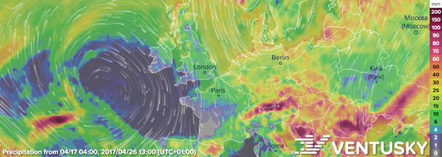
However, if you look at the GFS output on Ventusky (for the 26th) you can see a very nice, clear (and not atypical) setup of an Atlantic High and a Scandinavian Low combining to bring a strong northerly flow over Europe next week. Here you go...


Live link so you can run the animation from today if you like...
https://www.ventusky.com/?p=52.1;-0.4;4&l=rain-ac&t=20170426/12&m=gfs

Zoom out a bit for best effect. That's the sort of set-up we would have liked to have in December and January, and it may not happen next week but that's the way GFS is leaning at the moment. You can see where all the cold and precipitation in the long-range forecast is coming from.
The Admin Man

Topic last updated on 01-May-2017 at 11:50