Looks like another fine day for Zermatt...
Still snowing in America, while it's been Spring-like in Europe.
This Week's Snow Headlines - 21st February 2019
No notable snowfall in the Alps (or Dolomites or Pyrenees)
- Mammoth Mountain and Squaw Valley report most ever February snowfall totals.
- Scottish snow pack wiped out by warm weather.
- Mammoth Mountain to stay open to July 4th.
Most ski areas in Europe have not had any fresh snowfall for around 10 days now since temperatures warmed to 'spring-like'. Clear skies have meant there's been no precipitation of any kind anyway though, just glorious sunny days on the deep bases that build up through January and the first half of this month.
Lots of families away for the half-term holiday have been enjoying excellent conditions on the groomed runs, although obviously 10 days with no fresh snow and often warm temperatures means there's precious little off-piste powder left for freeriders to find now.
The avalanche danger has dropped considerably from the Levels 4 and 5 of a fortnight ago during the last heavy snowstorms and are more typically at level 2-3 now, although Tuesday's avalanche in Crans Montana where the risk was at Level 2 shows warming temperatures can cause snow-pack instability issues as much as heavy snow and wind.
There's no big change in the forecast so far, just the first signs of light snow in the Eastern Alps with possible snow showers at the end of this week in a few places, but no obvious game changer.
It's a similar picture in the Alps, Dolomites, Eastern Europe and the Pyrenees; but in Scandinavia the snow has kept falling so that's the place to be this week if you like your snow fresh. Scotland isn't alas, as the warm weather in the UK has thawed away the snow-pack there.
Across the Atlantic, it's almost the direct opposite picture to the Alps as there have been more huge snowfalls in California with resorts reporting up to 30cm of snow a day throughout the month on average or as much as nine feet (2.7 metres) of snow in 72 hours at times. Most of the rest of the continent's ski areas have seen fresh snowfall too, although not quite so much.
In the Alpine Forecast
The present settled, clear and mild weather in much of the Alps looks set to continue for at least another week and probably into the start of next month - although the East (Austria) will see colder conditions and some snow over the next few days - with up to 20cm possible in a few places.
Most of the forecast models are hinting at a possible breakdown around the second week of March but that's beyond their reliable timeframe for now.

See where it's expected to snow this week...
Re-publication :- our Snow Report Summary, being the text above this line, is free to re-publish, but must be clearly credited to www.J2ski.com with text including "J2Ski Snow Report" linked to this page - thank you.
EUROPEAN ALPS
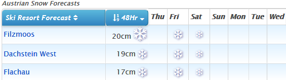
Austria
In common with most of Europe except Scandinavia, there's been more-or-less zero snowfall in Austria over the past 10 days during the warm weather. Most skiers have been enjoying the sunny days on the slopes though, with the snow lying very deep after the huge January snowfalls. The country's glaciers have the deepest bases at 4m+ but conditions are good pretty much everywhere.
There is little change in the forecast although we do see the chance of some light snowfall at some resorts. Particularly in Salzburgerland, through the end of this week; up to 15cm of snowfall is expected (though much less at most resorts) with temperatures dipping back below zero.
France
Very similar conditions in France – warm in resort, particularly the lower altitude traditional resorts, better snow conditions up high – with wonderful sunny days on the slopes. Although the heavy snow arrived later in France than Austria bases have built to 2 metres plus on upper slopes so look good across most of the country to withstand the thaw. Down at village level snowpacks are thinner but should still last a few weeks yet even at lower resorts and even if temperatures stay warm (as they currently look set to for the time being).
Resorts like Chamonix and Morzine still report 50-70cm of cover on valley runs.
Italy
A very similar picture again in Italy to the rest of mainland Europe – no fresh snow for a couple of weeks, sunny skies, great conditions on the slopes.
Italy saw some big snowfalls across its northern ski areas in the first week of this month and that means almost all of the country's ski areas are currently fully open with all slopes open and all lifts operating. Snow bases are as high as 4 metres up on the glaciers and even down in town in the Dolomites which have had less snow this season, most areas report at least 50cm of cover which should hopefully withstand temperatures reaching the high single digits (Celsius) over the weekend.
In the long term, there are signs of a change and the return of snowfall in 10-12 days' time but that it is too far away for a confident prediction.
Switzerland
Sunny in Switzerland as well with warm temperatures in resort again and sometimes above zero even on higher slopes as well. Although the recent heavy snowfall in California has taken bases up to challenge Swiss dominance in the 'deepest base in the world' table this season, Andermatt's 6m and Engelberg's 575cm are still in first and second places on the planet.
At the lower end of the slopes though bases are getting thin at resort level in a number of resorts – 40cm at Zermatt, 20cm in Gstaad and 10cm in Crans Montana. As with the rest of the Alps, there's no real snowfall in the forecast for the week ahead, just the possibility of light snow up high early next week.
Scandinavia
There have not been any massive dumps to report but, unlike the rest of Europe, there has at least been some snowfall in Norway and Sweden over the past week, with the biggest accumulations in resorts like Voss in western Norway which has had more than 30cm (a foot) of snow over the past week.
Most Scandinavian ski areas have had at least 10cm and some as much as 20cm of new snow in the past week though.
Pyrenees
A very similar picture in the Pyrenees to the Alps with no fresh snowfall for several weeks but bases built in January and earlier this month meaning resorts in the region typically have 50-100cm lying at the base level and 1.5 – 2.5 metres up top.
Cauterets in the French Pyrenees still reports 4 metres up top, the deepest in France by some distance. If anything though it's currently forecast to get warmer, possibly reaching +14C at resort level in Grandvalira on Saturday. Temperatures should start to drop again after that but not below zero again in the immediate forecast.
Scotland
The warm weather over the past 10 days in Scotland too has had much more serious consequences than it did in the Alps. After finally building thin bases following the warm dry December and January in Scotland, the recent temperatures have melted it all away. Cairngorm, the Lecht and Glencoe are essentially back to offering the small areas of beginner terrain at their bases made possible thanks to their new all-weather snow-making machines.
Nevis Range also has a beginner run with its plastic slope up at the top of the gondola. Glenshee can no longer offer snowsports at present. Again there no significant change in conditions on the horizon with the current forecast.
Eastern Europe
Although it has been a largely dry week in Eastern Europe, unlike most of the rest of the continent, there is snow forecast in Bulgaria for the coming weekend - hopefully as much as 20cm. This may not be ideal for upcoming world cup races in Bansko, but should freshen up the slopes nicely. But, as elsewhere in Europe, bases are good and almost all runs are open across the region.
North America
Canada
Temperatures have warmed up from the super cold, dry, conditions in Canada a fortnight back now and have even been climbing up close to zero at some resorts. It has been changeable weather across the country with alternating sunny and snowy days at many, although the majority of the snowfall in the past week (up to 40cm of it) has been in the west in Alberta and BC.
The week ahead looks like equal amounts of snow, pretty much, across the country however with 20-40cm forecast from BC to Quebec.
USA
American resorts have topped the world snowfall total tables for the third week running with more huge snowfalls in the west of the country. Resorts in Pacific Coast states including California and Washington have reported up to 2.7 metres (nine feet) of snowfall in the past week (on top of similar huge snowfalls in the previous two weeks) and base depths at many are creeping up past 4m (13 feet) and even five metres towards six metres/20 feet. Mammoth Mountain remains on top at 572cm – third deepest in the world.
It's not just the far West though, there have been more good snowfalls in the Rockies in Colorado and Utah too and fresh snowfall in New England as well - resorts in Vermont, for example, reporting up to 15cm (six inches) of snow in the past 48 hours.