
Re-publication :- our Snow Report Summary, being the text up to "The Alps", is free to re-publish, but must be clearly credited to www.J2ski.com with text including "J2Ski Snow Report" linked to this page - thank you.
Hello, and welcome to our final round-up of 2015,
And it's a good one... with snow (lots) in the forecast for Europe, but first... A Happy (and snowy) New Year from all of us at J2Ski.
This Week's Snow Headlines
- Heavy snow forecast for the Alps - up to 1.5m (five feet) possible over coming week.
- Scottish ski areas open for the first time this season (then close again).
- Significant snowfall in Eastern North America at last.
- Up to 40cm of fresh snow expected in the Pyrenees.
- Resort with deepest snow pack in world at present, Timberline in Oregon, hits 3.5m depth.
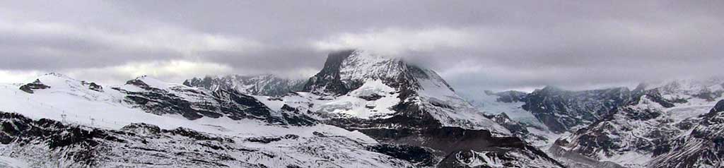
Clouds gathering around The Matterhorn today
At last, after a dry December in most of the world's leading ski regions (with the notable exception of Western North America) a big change in the weather seems to be on the way in some places, and has already started in others.
The most exciting news for most skiers is a lot of fresh snow forecast for the Alps over the coming week which should transform conditions. There's also expected to be healthy snowfalls in the Pyrenees and, to a lesser extent, the Dolomites.
The snow has already started to accumulate in Eastern North America which had been suffering badly too, up to 20cm in 24 hours was reported at some areas in the region. Scottish areas have been able to open their slopes, briefly, for the first time in 2015-16.
In The Alpine Forecast
Thanks to all those who managed a Snow Dance last week! It's coming... as we write this, it is starting to snow - albeit lightly - in The Alps.
As the outlook is quite dynamic, we've covered it at length in a forum post this morning :- The Snow Forecast for The Alps.
The Alps
Austria
With the exception of its glacier resorts, Austrian ski areas have tended to have some of the worst snow cover of the big four Alpine nations during the dry December, particularly at lower lying ski areas like Mayrhofen and Zell am Ziller where depths have been just a few inches. The forecast snowfall should, hopefully, lead to a dramatic improvement by this time next week, although so far accumulations are not expected to be quite so big as further west in France and Switzerland. The biggest forecasts are for around three feet of snow in the Arlberg, slightly less (80cm) in the Otztal areas of Obergurgl and Solden and 30-60cm for most Austrian areas.
France
After the largely snowless December, forecasts indicate that up to 1.6m (over five feet) of fresh snow could accumulate in the coming week, beginning with small falls on New Year's Eve, with up to a foot expected at many resorts by the end of Saturday – meaning change over day could be tricky. Longer term forecasts are that more than a metre of snow will fall in many areas by this time next week – with the biggest numbers (4-6 feet) for the Chamonix Valley, Les 2 Alpes, Flaine and Alpe d'Huez. So current snow depths are fairly irrelevant but for the record they're mostly in the 30-60cm bracket although Chamonix claims 1.6m up top, the deepest in the country.
Italy
Italian ski areas, particularly those in the Dolomites, have suffered the most of Europe's leading ski nations, with almost no natural snowfall so far this season in the east of the country. Initial reports suggested that the new snow would miss the Dolomites again but thankfully later reports say there will be snow there at last, to top up the heroic snowmaking efforts that have seen hundreds of kilometres of piste open with entirely machine made snow. To the west of the country there are big snowfalls forecast for resorts like Cervinia. Most other areas in the Italian Alps get the same as French areas in the forecast – around two feet or more. In the dolomites there's currently 20-30cm expected.
Switzerland
Switzerland too is set to receive a healthy snowfall for the first week of 2016. It's great news as the battle to keep a thin ribbon of snow down to resort level at several resorts has finally been lost in the last week. Resorts including Verbier and Zermatt should see accumulations in excess of one metre over the next week. Again, whether those numbers are realistic or not, healthy snowfall is expected across the country, with the smallest forecast 25cm for Lenzerheide but most expecting up to a mere or more by this time next week.
Scandinavia
In Scandinavia it's been warmer than usual but the snow has kept falling and base depths have kept up – typically in the 40-60cm range at most areas. Quite a lot more snow is expected in the coming week, especially at Norwegian areas where up to 60cm may fall.
Pyrenees
After a snowless month the Pyrenees, which got the best of the snow at the end of November, may get 20-40cm of fresh cover in the snow storms over the coming week. The biggest snowfall estimates are for the Spanish side with areas like Baqueira Beret expected to receive more than a foot. On the French side the numbers are slightly smaller and in Andorra 10-20cm is expected at present, although those numbers keep changing as the expected snow storm comes closer.
Eastern Europe
Snow depths are set to receive a boost in Eastern Europe too over the coming week. Although forecasts for the area are less certain than in the west, accumulations of up to 60cm/two feet have been forecast down in Bulgaria, with so smaller falls of 10-20cm expected further north at resorts in Romania and Slovenia. As with further West this is great news, so long as it happens, as most areas have typically only 10/20cm on lower slopes and 30-50cm on upper runs of mostly machine made cover at present.
Scotland
Scottish ski centres have been fighting even more wildly fluctuating weather than usual. Along with strong gales interspersed with heavy snow or rain, temperatures have been roller-coastering up and down by as much as 15C in 12 hours on several occasions, going from -5 to double digit positive temperatures, so it's hardly surprising operations are problematic. Nonetheless two centre – Nevis range and Cairngorm, were able to open small beginner areas on Monday 28th, the first opening this winter, before gales and warm temperatures shut them down the next day. All hope to re-open soon as colder, more stable weather returns, for a few days at least.
North America
Canada
Ski areas in Eastern Canada have finally had more 'normal' conditions in the last few days and Les Massif in Quebec even managed to post the area's first powder alarm of the season with 20cm of fresh snow in 24 hours on Tuesday/Wednesday. It's all very late in the day but at least means most centres in the East can join those in the west and offer fresh snow for the New Year weekend, traditionally the world's busiest ski weekend. Mont Tremblant posted the biggest snowfall in Canadas and the biggest snowfall by far of any Eastern North American ski area in fact with 40cm of snow, there was 20cm at Mont Ste Anne. Big White in BC still has the country's deepest snow with 232cm, Whistler got the most snow in the West this past week with 17cm.
USA
For the first time this season, ski resorts in Eastern North America have posted bigger snowfall figures this past week than those in the West (with the exception of another two feet of snow at Alyeska in Alaska). There's been 10-20cm in Eastern US areas, dramatically improving conditions, with snowmaking systems working at full blast too. Out west the snowy deluge of the past two months has slowed to just a few inches this week but snow depths remain excellent for this early in the season, and well above the seasonal average. Mammoth and Squaw Valley are both over 2m whilst Timberline in Oregon, which used to stay open year round but has been forced to close in summer and autumn for lack of snow the past two winters, now has a 3.5rm base depth – believed to be the world's deepest at present.