http://www.plandespistes.nl/Frankrijk/
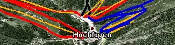
On the website http://www.plandespistes.nl you can find skiareas in 3D in Google Earth and/or Google Maps. Many famous resorts, like Alpe d'Huez, Les Deux Alpes, La Plagne, Les Arcs, Le Grand Massif, Val Thorens, Pra Loup and La Rosiere are online, and others will follow soon. Especially if you use Google Earth (or the Google Earth Plugin) it is fun to have a 3D look at your skiarea.
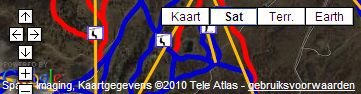
Please note that the loadingtime of the lifts and runs can take a few seconds, depending the size of the area and your connection.
Skimaps on Google Earth/Google Maps
Login
To Create or Answer a Topic
Started by Mapmundo in France 29-Oct-2010 - 6 Replies
Latest images on this Topic...
Mapmundo posted Oct-2010
Ian Wickham
reply to 'Skimaps on Google Earth/Google Maps' posted Oct-2010
MMmmmm not sure what use if any it will make
Dave Mac
reply to 'Skimaps on Google Earth/Google Maps' posted Oct-2010
There are some areas that have difficult piste maps, eg the schiwelt. Relief piste maps can improve on the standard maps.
Ian Wickham
reply to 'Skimaps on Google Earth/Google Maps' posted Oct-2010
Ski in France, never had any problems with piste maps 8)
ClipperJon
reply to 'Skimaps on Google Earth/Google Maps' posted Oct-2010
I've tried using map overlays of piste maps but getting the perspective right was pretty much impossible. Seeing a piste map on 3D terrain is fantastic- especially if you `fly` down the runs. I'll definitely be checking this out when I get home- saved me a lot of work!
Snowb4ndit
reply to 'Skimaps on Google Earth/Google Maps' posted Oct-2010
Take Life With A Pinch Of Salt... A Wedge Of Lime, & A Shot Of Tequila :-)
Ian Wickham
reply to 'Skimaps on Google Earth/Google Maps' posted Oct-2010
I really still do not see the point unless you are carrying a GPS unit to down load ski kilometres.
Topic last updated on 30-October-2010 at 14:06