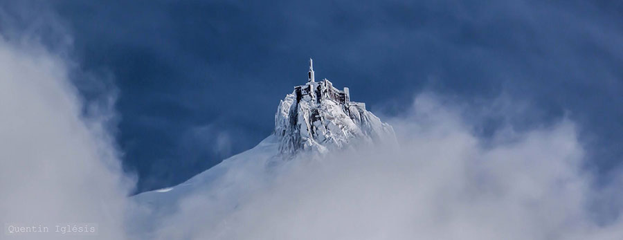
The Aiguille du Midi, Chamonix, in this great photo from Quentin Iglésis (Chamonix Photographer)
J2Ski Snow Report 1st March 2018
The extreme cold of the last week, gives way to a less-cold but snowier outlook in the Alps, and more snow for the western US.
This Week's Snow Headlines
- Very low temperatures in the Alps; as low as -30C at altitude.
- More heavy snow in Western North America (up to 41cm/16inches in 24 hours reported in California).
- Snow forecast for the southern Alps and Pyrenees.
- Temperatures hit 70F/20C in Vermont as US East Coast areas end seasons early.
- Deepest base in North America reaches 6 metres/20 feet.
The very low temperatures in the Alps have been the main story this week as we enter 'meteorological spring' on the 1st of March. Temperatures have been dipping as low as -30C at altitude in the alps and below -40C in Lapland, closer to the Siberian epicentre of the current 'Beast from The East' cold front.
The weather has not brought too much snow as yet, although the more southerly slopes in Europe have seen some significant snowfall including in the Pyrenees (again – definitely the place for fresh snow in Europe through February), and the southern French and Italian Alps. This currently looks set to expand over the latter half of this week with 30-60cm of snowfall forecast by Saturday for some more southerly French and Italian areas.
Across the Atlantic there's a real East/West split with the weather in the east way too warm, severely limiting what terrain areas can open and indeed leading some more southerly areas to close, probably for the season. In the west, the long awaited snow continues to fall in ever more abundance with reports of up to 41cm in 24 hours in California.
In the Alpine Forecast
The bitter cold of the past week is easing and temperatures across the Alps should be around - or even slightly above - seasonal averages by the weekend. That's going to feel positively warm in comparison!
Very unsettled weather is following, with widespread snow now in the forecast (and underway today). Heaviest accumulations are likely to be for the southern and western alps, with most areas with a good chance of 30cm (1ft) or more by the end of the weekend.
Avalanche and Off-Piste Risk - avalanche risk remains high in some areas, now compounded by slopes that have become icy in the cold (and sun) of the last week. As always, take local advice before leaving marked runs; have fun but stay safe!
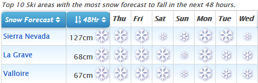
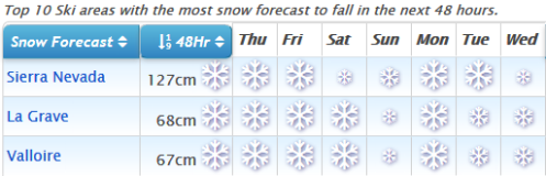
Sierra Nevada tops the charts! See when and where it's going to snow...
Re-publication :- our Snow Report Summary, being the text above this line, is free to re-publish, but must be clearly credited to www.J2ski.com with text including "J2Ski Snow Report" linked to this page - thank you.
EUROPEAN ALPS
Austria
It has been a largely dry week in Austria and looks set to be mostly dry over the week ahead. There have been some small snowfalls of a few inches at resorts like Obergurgl, and similar 5-10cm falls are forecast for quite a few Austrian resorts towards the end of the week, but it seems unlikely there'll be anything terribly significant. The good news is that established bases (The deepest remains at 595cm/20 feet in the Kaunertal glacier) mean that most Austrian areas are looking good for their final 4-8 weeks of the season, even if there's no fresh March snow. It's cold though, with temperatures forecast to be -20 to -30C on higher Austrian slopes through this week.
France
It has been dry and very, very cold in the French Alps over the start of this week with temperatures dipping as low as -30C at altitude on the ski slope. Les Arcs reported -27C on Tuesday. There has been some more snow in the French Pyrenees and in the most southerly French resorts in the Alps like Isola 2000, and more snowfall is expected here over the next few days and to extend further north with possibly as much as a foot (30cm) of fresh snow in Chamonix, Tignes, Les 2 Alpes and Alpe d'Huez and up to 60cm at more southerly French ski areas. Otherwise though conditions continue to be good across the country with still deep snow depths and most runs open and lists operating as we enter March.
Italy
Italy has seen some of the biggest snowfalls of the past week – topping the tables on most days for areas getting the most snow in Europe during any one 24 hour period. The areas were not the usual suspects either.
First up Piedmont in the West, but south of the Aosta Valley which was so dumped on in January; then Tuscany where one small centre reported 50cm of snow in 24 hours at the weekend. So Italy is one of the best choices for fresh snow this week, particularly west and central. The Dolomites have been more dominated by sunshine but all areas, like all of Europe, have been cold too. More snow is forecast in Italy up to the weekend with the same areas as before likely to get the most of it with up to 60cm forecast in Piedmont region again and up to 40cm in the Apennines.
Switzerland
Not a huge amount of fresh snow on Swiss slopes this week, just a few centimetres reported here and there. Once again the main factor is the cold with temperatures in the range of -15C to -30C the norm through the middle of this week. It is set to warm up somewhat towards the weekend when a few centimetres (Typically 5-10cm) more fresh snow is expected on some Swiss slopes. Engelberg continues to post the world's deepest snowbase at 6.2m (nearly 21 feet), but many other swiss resorts have good bases in the 2-5m bracket, particularly on upper runs, so it continues to look good in Switzerland as we enter March.
Eastern Europe
Not quite such cold weather in the East of Europe, at least when you go as far south as Bulgaria where temperatures have been more in the -5 to -10 range after about 10cm of fresh snow at the weekend. Most runs are open in Bulgaria and almost all lifts operating with Bansko posting the deepest base depth at 40-230cm.
Scotland
Scotland has had another good week and reports it has now passed the 200,000 skier days mark. There were more clear, blue sky days at the start of this week and almost all runs remain open at all five Highland centres. The 'Beast from the East' weather system did lead to the temporary closure of the three Easterly centres (Glenshee, The Lecht and Cairngorm) midweek but it has not brought a huge amount of fresh snow so far, with most of what has fallen landing further south.
Pyrenees
The Pyrenees have had some of the best snowfalls through February and there's been more of the same over the past week and more fresh snow forecast for the week ahead.
Pretty well every ski run is open in Andorra at present where there was 10-15cm of fresh snow this past week. A bigger snowfall – totalling more than 40cm – is now expected by the weekend. Bases are at around 2 metres across the country so it looks good for March and indeed April. There are similar snowfalls, bases and forecast on both the French and Spanish sides of the mountains too.
Scandinavia
It's mostly sunny, but cold, in Scandinavia, where resorts are reporting temperatures of -20C to -30C, perhaps less unusual than the low temperatures in the Alps. -40C was reported to have been reached in Lapland too. Not much snow with the clear dry, days but 5 – 10cm of fresh has been reported in the West of Norway, the most at Roldal which is also posting the deepest base in the region at 3.8m.
North America
Canada
It has been quite snowy in East and west Canada this week with Fernie in BC, for example, posting 27cm (11 inches) of fresh snow in the last seven hours, whilst Massif du Sud in Quebec has reported 13cm (5 inches) in the same period. Most resorts across in Canada are reporting conditions as 'snowy' and likely to continue so through the rest of this week. With bases good, particularly in the west, and most runs open, it looks like a powdery start to March here.
USA
It appears to be all change in the USA. A few months ago, at the start of the year, it was exceptionally cold and snowy in the East whilst the West was dry and warm. As we enter March there have been big snowfalls in the West but ski areas in the east are struggling with the thermometer reported to have hit 7OF at the weekend in Vermont (around 20 Celcius) and ski areas in North Carolina and other areas further south have been forced to close early for the season due to the warm temperatures.
California continues its 'late surge' on winter 17-18 with more heavy snowfall at most of the state's ski areas. So in the west we're seeing reports of over 40cm/16 inchers of snow at Mt Rose in California whilst Killington in Vermont in the east has half of its terrain open and little cover on lower runs.