Re-publication :- our Snow Report Summary, being the text up to "The Alps", is free to re-publish, but must be clearly credited to www.J2ski.com with text including "J2Ski Snow Report" linked to this page - thank you.
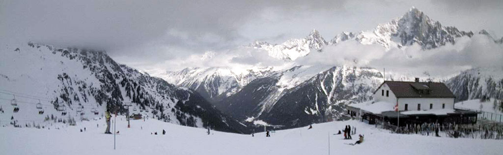
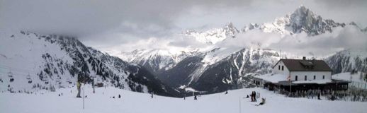
The view from Brevent, Chamonix, this afternoon
A lighter week to report, but the snow keeps coming...
This Week's Snow Headlines
- Chamonix passes the 4m Snow Depth Mark.
- Alyeska in Alaska has now had more than 14m/47 feet of snow this season.
- Three feet more snow at Avoriaz.
- Big snow in Quebec, Tremblant gets 41cm in 24 hours.
- Mammoth posts deepest snowbase in the world at present at 4.3m.
- Sierra Nevada in southern Spain finally gets significant snowfall.
A week without any dramatic snowfalls to report; just good old fashioned top ups of snowbases all over the northern hemisphere, with around 90% of ski centres seeing some snow, some as much as 90cm/three feet, most nearer a third of that.
In The Alps it has kept snowing and got colder, the temperature drop being especially welcome in this season that has too often seen rain at lower elevations. Most noteworthy perhaps was more snow in the Dolomites, fresh snow in the Pyrenees and even stable conditions in Scotland.
Not a lot happening across the Atlantic although big snowfalls in New England and Quebec saw East Coast beat West Coast for snowfall totals for only the second time this season.
In The Alpine Forecast
Heat wave! But it won't last long; this coming weekend will see a steep rise in temperatures in much of The Alps... followed by an equally steep fall as next week begins. This Sunday and Monday look clear and mild (warm in the sun), although temperatures will drop sharply into Tuesday.
That temperature drop looks like ushering in a period of un-settled (and snowy) weather that we expect to last through to the end of the month. There are a couple of promising snowfalls in the forecast for next week (currently Tuesday and Thursday) and more to follow those.
The Alps
Austria
Less snowy this week than the past few in Austria, but still quite snowy with every ski area in the country posting some snowfall, most 10-20cm, some (Ischgl) as much as 40cm. There's been another foot (30cm) in the past week at St Anton and Kitzbuhel has had 25cm (10 inches) as has powder pocket Fieberbrunn. It's still not quite a classic winter, with resorts in the Ziller Valley including Mayrhofen and Zell still struggling for resort level snow, although on the higher slopes conditions are pretty good. The Kauntertal glacier is posting by far the deepest snowbase in the country at 386cm, more than a metre more than closest contender Solden. More moderate snowfall is expected in Austria over the coming week.
France
France has had more healthy snowfalls over the past week with up to three feet of fresh snow reported (at Avoriaz) and the deepest snow base (Chamonix) pushing through the 4m mark. Generally the picture is good across the country's ski areas although there remains an issue of snow cover at lower level resorts like Samoens. Most have 30-90cm bases and some like Meribel, Avoriaz and Val Thorens over a metre now at resort level and double that higher up – meaning they should be good for the rest of the season now. Small to moderate snowfall accumulations are expected over the coming week.
Italy
Italian resorts have also had less snow than a week ago, but still some, and thankfully it has continued to fall in the Dolomites as well as in the West of the country. San Martino posted a powder alarm for 20cm of fresh snow in 24 hours yesterday (Wednesday) and Alta Pusteria reports 60cm (two feet) of fresh snow. The biggest accumulations have been in the Aosta Valley with Pila and la Thuile reporting 60cm and 75cm of fresh snow respectively in the past week, but Arabba in the dolomites has had another foot (30cm) in the same period. La Thuile also has the country's deepest snow base at 2.7m (9 feet). 30-60cm of snow is forecast across the country's ski areas in the coming week.
Switzerland
Moderate snowfall in Switzerland too with a return to the most-snow-in-the-west pattern with Verbier adding 45cm this past week, St Moritz 5cm. Snow depths remain pretty good across the country with most areas having 50cm-1m at resort level and 1m-2m on upper slopes, Engelberg still the snowiest in the country with a 3.5m base. A few resorts do have thinner cover at resort level with Champery and Grindelwald in the 10-15cm bracket. Much bigger snowfalls – possibly up to a metre, are expected in the next seven days.
Scandinavia
Not much snow reported in Norway over the last week although resorts like Voss have the region's deepest snow base now at 1.8m. There's been more snow than normal up north in Lapland though with a foot (30cm) of fresh at Yllas and bases in the area around the metre mark. More snow in Sweden too with 20cxm for the biggest centre, Are.
Pyrenees
It has been the snowiest week in a while for the Pyrenees with most areas posting 30-40cm of fresh snowfall across the region. Bases have been boosted to around the metre mark and resorts are reporting powder conditions. Sierra Nevada down in the south of Spain, which had had almost no natural snow all season and relies on natural snowfall has finally had a healthy fall this week. Similar snowfall is expected over the coming week too.
Eastern Europe
There have been moderate snowfalls across Eastern Europe with leading resorts in Slovenia, Romania, Slovakia and the Czech Republic all reporting 20-25cm of new snow in the last few days. None of the expected snow arrived in Bulgaria, apparently, but snow depths remain good at around the metre mark.
Scotland
Conditions have been largely stable over the past week in Scotland with most centres open most days and relatively good conditions and most terrain open. There have been a few inches of fresh snow, particularly last weekend and up to 30cm more is expected over the coming week. Lowther Hills in the south of the country have also had a good snowfall in the past 48 hours.
North America
Canada
There's been another foot of snow in Western BC but the big news from Canada this week is that Mt Tremblant in Quebec has posted one of the biggest powder alarms on the North American continent with 41cm in 24 hours Tuesday/Wednesday having seen very little natural snow all season until now. Fernie, which reported 15cm of snow in the past week, has the deepest base in the country still at 2.5m, a few centimetres ahead of whistler which reported 30cm of fresh snow this week.
USA
A quieter week in the USA with the biggest snowfalls reported in the East of the country for only the second time this season. Sugarbush in Vermont hit 45cm/18 inches of fresh snow, beating the 14 inches at Breckenridge out west in Colorado – the most on that side of the US. Mammoth still has the biggest snow base in the region at 4.2m up top, although its only had a few inches of snow this week. That's about to change in the next 48 hours however as several feet of fresh snow are expected by the end of the weekend.