Messages posted by : admin
|
Yep, we've been watching the forecasts and not really believing the amounts - to see substantially more than predicted start to arrive in many places... a proper Stau!
Enjoy, but stay safe! I'm sure you'll be aware, but for our other readers; Avalanche Risk Levels are expected to go to 5 (the max) in some Austrian areas tomorrow. Austrian airports, roads and resort access have already been disrupted today and it's expected to be worse over the next few days. Should be epic when it settles down! Oh, yeah, and pictures or it didn't happen! :thumbup: |
|
Saalbach Hinterglemm Snow Reports - January 2019
Started by User in Snow Reports from Ski Resorts, 6 Replies |
|
Just for you... here's a reminder of what a French lift queue looks like (December 2016)... 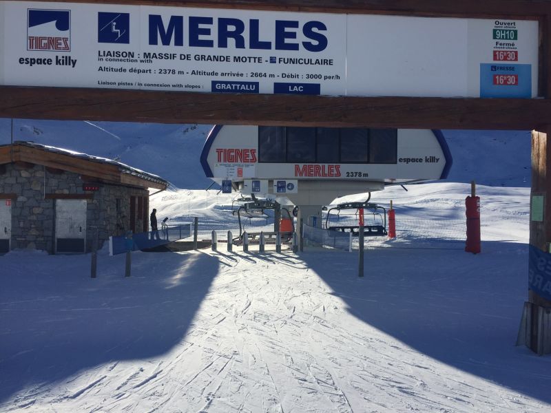
:P ...but Austria FTW this week, so far as snow goes... :thumbup: Furthy - can we have some more please; car parks are lovely, but do you have a bit more mountain content? |
|
|
J2Ski Snow Report 3rd January 2019
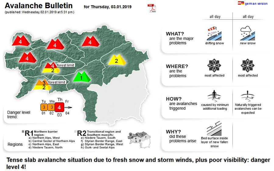
Heavy Snow means Avalanche Risk 4 (High), across much of Austria, including Steiermark today - see the full Avalanche Bulletin for more info. Deep cold and heavy snow for Austria, clear skies for France... for now! This Week's Snow Headlines - 3rd January 2019 - Austrian resorts report a metre of snowfall this week and up to 1.5 metres forecast. - Almost no fresh snow in France, but a little in the forecast. - Scotland sees double-digit Xmas and New Year temps but 3 areas open with snowmaking. - Andermatt in Switzerland still posting world's deepest snow base at 4.5m (15 feet). - Pyrenees still waiting for a good snowfall. Snow cover and snow quality in the Alps is clearly divided at the moment along lines of altitude and geography; higher ski areas generally enjoyed a snowy start to the season, while lower villages were often warm and rainy. Currently, there's a geographic divide with the East of the Alps and Eastern Europe seeing heavy snowfall, set to continue for at least the coming week, and the West and South not seeing any. This equates to a couple of metres of snowfall (a metre already and more than a metre more forecast) at some resorts in Austria and Germany, none at all for most in France and Italy. But change is in sight! Elsewhere the picture follows the weather split in the Alps to a large degree with no fresh snow and little if any forecast in the Dolomites and Pyrenees but a snowy week in Scandinavia. Across the Atlantic it has been snowy in the north and west once again, but 'unseasonably warm' still at lower latitudes in the East. In the Alpine Forecast With snow - literally - piling into the eastern Alps (Austria in particular) this week, it looks as if the western Alps (France) may get a bit of a refresh at some point next week. There's a lot of uncertainty regarding precipitation, where and when, at present but temperatures should be running cold (very cold at times) for the next couple of weeks with at least light snows quite widespread by the second week of January. 
See where it's expected to snow this week...
EUROPEAN ALPS Austria Austria has been both the snowiest spot in Europe over the past week and looks like it is set to be the same again over the coming week with forecasting models pointing to some big (metre-plus) accumulations for parts of the country. Saalbach was one of Europe's five snowiest places over the past week reporting 80cm of snowfall, mostly since the weekend after a dry and sunny period after Christmas which was common across much of the Alps. However, again a common factor, the snow that falls is mostly boosting upper base depths with the resort still posting a 40-130cm base. Most of Austria looks like it will stay snowy through the first 10 days at least of 2019 with accumulation forecasts ranging from 30cm in the Arlberg to over 1.5 metres, potentially, at resorts like Filzmoos and Flachau. France There's been no snowfall reported on French mountains this week, but still, most skiers are happy at the country's larger destination resorts as their high-altitude slopes received more November/December snow than in most of the past five autumns so almost all the slopes are open and on-piste conditions good - if a little hard in places. The powder is, obviously, getting harder to find now. Lower slopes are not in good shape and valleys below 1500m are looking pretty green. That's a problem at some of the country's small, local ski hills, some of which are yet to open for the season. But snow depths for the major ski resorts are typically in the 1-2 metre range on upper slopes (Serre Chevalier is posting the deepest at 202cm) and the bigger resorts can push snow down pistes to the base where natural cover is limited so most have top to bottom skiing too. Italy The picture in Italy is very similar to France with only the Northeast of the country along the Austrian border reporting snowfall and again it's looking like a similar picture for the week ahead, although with perhaps a few centimetres of snow in the Dolomites. Dry weather and lack of snow at lower levels are not causing many problems for the country's leading resorts thanks to good autumn snow accumulations at most areas in the west and snow-making in the Dolomites. In the Milky Way region (straddling the French border) all connections between resorts are now open, for example. Madesimo continues to post the deepest snow in the country of the major resorts at 2.5m, whilst the only areas posting significant snowfall (36cm in the past week) are Speikboden in the south Tyrol and Valle Isarco in the East. For most others it's 10cm or less. Switzerland Switzerland lies on the dividing line in the Alps between French and German-speaking regions (Italian too) and also last week and next week at least, in terms of weather fronts. There's been some snow; mostly on the Eastern side of the country. Generally, conditions are clear and sunny with the most snow expected for the coming week in Easterly areas like Davos and Samnaun which may get as much as 30cm (a foot) of snow. Scandinavia A mostly snowy week in Scandinavia which has given lots of areas a boost. In fact, one small Western Norwegian ski area, Roldal, reported the most fresh snow in Europe over the past week – 105cm (3.5 feet) including 60cm (two feet) in the first 24 hours of 2019. Elsewhere it has been more in the 5-20cm accumulation range in most cases which is a good fall by Scandinavian standards. Base depths across the region are generally in the 30-90cm bracket with most runs open and most lift's operating. Pyrenees Alas, there has been no new snow reported in the Pyrenees over the past week and there's also nothing forecast here for the week ahead so it's something of a holding pattern. Bases are not great at 20-50cm across the principality but none-the-less at least half of runs are open at each area so they are making the best of it. Scotland It's increasingly looking like a savvy move to buy all-weather snow-making systems at three of Scotland's five ski hills this winter as they've been able to operate at least some skiing through Christmas and New Year when the other two haven't as a mild December has left slopes fairly bare. Glencoe, The Lecht and Cairngorm are all open thanks to the machines, Glenshee and Nevis range are not offering snowsports. Temperatures have now dipped back below freezing and there was a little fresh natural snowfall on hilltops on New Year's Eve but it's now dry and temperatures are set to climb again before it rains. Eastern Europe Eastern Europe has been seeing some steady snowfall to start 2019 with resorts in the north – the Czech and Slovak Republics and Poland, issuing powder alarms for 20cm+ snowfalls in 24 hour periods and it's looking like it will stay snowy into next week with another 30cm expected by many at the weekend. Further south (Slovenia, Bulgaria) has been less snowy but unlike on the Western side of the mountains there has been some snow to freshen up conditions, if more like 5-15cm here. North America Canada After the snowy deluge in Western Canada up to Christmas things slowed down a little over New Year with most of the fresh snow falling in the past 48 hours reported on the eastern side in Quebec, where it is a bit of a relief after unseasonably warm weather in late December. Mont Ste Anne, where the base had dropped to 90cm and Tremblant both reported more than 20cm of fresh snow. However, things are about to turn very snowy again the west with areas in Alberta and BC likely to see 40-80cm and at Whistler Blackcomb potentially 1.8 metres (six feet) over the coming week! USA A mostly snowy week for most of Western North America although something of a re-set with ski areas in traditional ski states like Colorado, Utah and Wyoming posting the biggest accumulations, wrestling back the initiative from Washington state and others in the Pacific Northwest which had been posting the biggest numbers for much of December. That said, Alpental in Washington still has the deepest base (323cm) and Alyeska in Alaska posted 76cm of snowfall in the last 72 hours, one of the biggest accumulations this week. On the east it has stayed 'unseasonably warm' in more southerly ski areas but is looking snowier further north into New England. The week ahead looks fairly quiet with the biggest accumulations likely back in the West with potentially up to 50cm falling in California, although that forecast is a little long-term for the start of next week, so a little less certain than the (mostly dry) next 72 hours. |
|
|
J2Ski Snow Report 27th December 2018
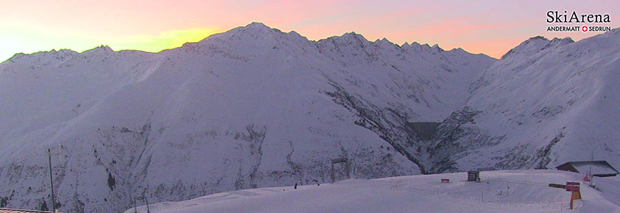
Dawn breaking over a snowy Andermatt this morning... With our last weekly round-up of 2018, we'd like to wish you a Happy New Year! This Week's Snow Headlines - Ski areas in The Alps report up to 1.2m (4 feet) of snow in past 7 days. - Third Scottish ski area making snow With 'all-weather' machine. - Most ski runs in the Alps groomed and open for New Year. - Pyrenees and Dolomites waiting on significant snowfall (but mostly open). - Some small ski areas in North America close temporarily due to warm, wet weather. - Deepest base in Europe (and the world) reaches 4.5 metres. There's mixed snow news for New Year in the Alps with more healthy snowfalls bringing up to 1.2 metres of new snow in the past week and taking Europe's deepest base up to 4.5 metres. There has, however, also been unseasonably warm weather with rain as high as 2000 metres at times, removing snow cover in some valley resorts and leaving wet snow at low elevations. Compared to many recent Decembers, most resorts are very happy with the state-of-play for New Year, however, and what will for many be the busiest week of the season. Many have all, or almost all, of their runs open and lifts operating and the weather is generally benign for some great days on the slopes. Elsewhere there's not been much snow in the Pyrenees, Dolomites or Scandinavia but again most (if not quite so much given the thinner bases) of the terrain in each of these regions is open. In Scotland there's not enough natural snow to open but the centres with the new-for-this-season all-weather snow-making machines are operating. It's a not dissimilar picture across the Atlantic either with less fresh snowfall but still some healthy dumps, particularly at the start of last weekend, but also warm temperatures and rain causing issues at smaller, lower resorts on East and West coasts and in the Midwest. In the Alpine Forecast A further week of mild and clear weather is in store for most of The Alps, with little new snow. The outlook beyond that is very unclear at the moment, and the forecast models are struggling to agree on some potentially significant pattern changes. We hope to have some more clarity on that next week - it could be interesting! 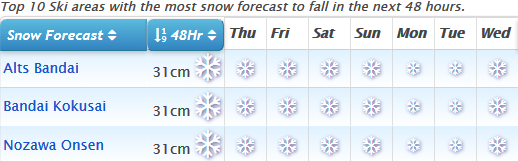
See where it's expected to snow this week...
EUROPEAN ALPS Austria It was a snowy Christmas in Austria with ski areas reporting up to 70cm of snow over 72 hours at the start of this week. Temperatures remain mild, however, and at many resorts it was raining at resort level and on lower slopes. So powder up top but not so much picture-postcard snug snowy villages so far unless it's up high. The forecast is for fairly stable weather over the coming week with temperatures again warm in resort but well below freezing higher up so at least bases building up top should be maintained. Solden is on 299cm, the deepest in the country, after another 50cm since Sunday. France French resorts did not see so much fresh snow as Austrian over the Christmas period with most reporting only 5-15cm of fresh cover. There were bigger snowfalls last Friday-Saturday when the 3 Valleys and Paradiski got a little more than 20cm in 24 hours. The bad news was that it rained up to as high as 2000 metres, leaving snow conditions rather soggy in places, particularly on lower slopes, and the off-piste snow pack stodgy and unstable. Despite this, snow depths are good and in fact some of the best they've been this early in the season in recent years, and most areas have 90-100% of their terrain open for the Christmas/New Year holidays, which again is one of the best situations in terms of open terrain in the past five years. The coming week looks fairly dry in the French mountains. Italy Italy has seen very little fresh snow in the past week. The biggest accumulations came in the North when snow falling predominantly in Austria and Switzerland at the start of this week crossed the border to reach northern Italian areas and on Friday/Saturday last week when from the French Alps crossed a little into northwest Italy too. The Dolomites, however, have stayed dry. But as with other Alpine nations there's enough cover to open most of the country's ski runs in time for New Year. The deepest snow at present for the main resorts is at Madesimo where it is lying 2.5 metres thick – not bad at all for December. In Val Gardena it's 5-40cm but still almost every run is open. Switzerland Swiss ski areas continue to post the world's deepest snow depths, topped by Andermatt where another 50cm of snow in the past 72 hours appears to have bolstered its depth on upper runs from 400 to 450cm – the deepest in the world by some distance and ten times the stat for resort-level snow. As with the rest of the alps most of the country's leading areas are fully open which must come as a relief after what was reported to be the third warmest Autumn in the country on record, especially with so many posting good early-season snow depths up high at least. Scandinavia A fairly quiet week in Scandinavia with little snowfall reported. Some of those getting bigger accumulations in the last few days including Voss in Norway (15cm) and Ramundberget in Sweden (32cm). Base depths are fairly unspectacular so far but adequate for most of the larger resorts like Are, Hemsedal and Salen to have at least 30 runs open for the Christmas and New year holidays. Pyrenees It has been stubbornly non-snowy in the Pyrenees and there's no snowfall on the horizon for another week at least it seems, plus temperatures have been up above freezing recently. That all being the case, the principality's main centres report at least half their runs open, around 90% in Grandvalira's case. Upper slope base depths are 40-50cm. Scotland It's not looking good for fresh snow in Scotland over the Christmas and New Year holidays, other than the short runs made with the all-weather snow-making machines at Glencoe, The Lecht and most recently Cairngorm. There is some natural snow up high but temperatures are now rising again to double figures in the valleys so there's likely to be more thawing. No signs of change in the near future. Eastern Europe A mix of conditions in Eastern Europe (as usual) with some fresh snow in the west of the region, but less the further East you go. Poland's Dwie Doliny Muszyna reported 20cm of fresh snow over Christmas/Boxing Day, the biggest 24-hour accumulation in the region. There was also 5-15cm of fresh snow at many areas in the Czech and Slovak Republics. Less fresh snow in Bulgaria but most of the areas have at least half their terrain open. Pamporovo reports upper base depths have hit 1 metre, at Bansko it's closer to 50cm. North America Canada Mt Washington on Vancouver Island off Canada's West Coast posted the biggest snowfall of the past week at just under 90cm (three feet) - as the nearly three-week-long snowstorm that has been hitting the country's West Coast off the Pacific appears to be finally easing. It has left ski areas in BC taking the top 8 of the table for the country's deepest bases having previously been low down in the rankings, topped by the continent's largest area, Whistler Blackcomb, on 215cm. Most of the ski runs there are now open too. It's less good news in the east where several smaller areas in Quebec have been forced to close temporarily due to unseasonably warm, wet weather. USA A mixed picture in the US too with more healthy snowfalls, particularly at the end of last week, but also an increasing number of ski areas announcing they were delaying the start of their season – or closing temporarily having already opened – due to weather too warm for snow-making (and rain). Ski areas on the East Coast have been particularly hard hit in that latter category. The more positive news has been big snowfalls, again, further West with Mt Baker (again) receiving the second most snowfall in the world over the past 7 days (119cm/4 feet). A number of resorts in the Rockies issued 24-hour 25cm+ powder alerts on Saturday. Base depths remain good at most and most have all or most lifts turning and runs open. |
|
|
I've just received the following comments from Bob, who I skied with on the Off-Piste course.
|
|
Yes, it is - there's a ski shop at the top station of the gondola, with lockers :- http://www.alpineve.it/en/storage/ |
|
Yes, I thought so. One thing that does stand out is the "customer loyalty" they've achieved; the majority of people on the courses last week were returning clients and many of them have done multiple weeks (5-10 or even more) over several years (like Alex, quoted above). I'll be interested to hear how Dobby finds it next month. |
|
|
J2Ski Snow Report 20th December 2018
La Clusaz, France, fully open from this weekend... Some big snowfalls reported, and good skiing for a fairly typical December so far. This Week's Snow Headlines - 7 Feet of Snowfall (2.1m) in 7 days at Whistler. - World's deepest base reaches 4 metres in Switzerland. - Snow expected from the weekend, for the Alps (and Whistler!). With one of the busiest fortnights of the season almost upon us, the outlook for Christmas across 90% of the skiing world is pretty good and certainly one of the best of the past five years. Most areas have seen fresh snow in the past few days and there's more in the forecast; the only real grumble is that it has been 'sticky' snow or even rain at lower elevations at times, but it is only mid-December so fairly normal. Up top, bases are building at most areas in the Alps and skiers are reporting both powder days and perfectly groomed corduroy. In Europe it is the Alps that are looking particularly good, the Dolomites and Pyrenees have not had much fresh snow since November and whilst they're able to open a lot of terrain anyway, that's largely thanks to snow-making. That said, the French Pyrenees posted 7 day totals of 47cm on Wednesday, the biggest in Europe after a fairly quiet snowfall week across the continent compared to the previous fortnight. Eastern Europe has a bit of a divide with ski areas on the 'Alps' side in countries like Poland, Slovakia and Slovenia looking snowy, but further east cover a bit hit and miss. Scotland got some snow at the weekend but temperatures got back to double figures midweek so there's no sign of any areas opening imminently, except for the small areas at Glencoe and The Lecht that have all-weather snow-making. In North America the big news has been on-going huge snowfalls in the Pacific Northwest where ski areas have reported up to 8 feet of snow in 7 days, and there's more in the forecast. Although it has been warmer (wetter) at lower elevations. Other parts of Canada and the US have also been getting fresh snow, just not so much. In the Alpine Forecast Temperatures look like running a little above average (for late December!) into next week, but there are some significant snowfalls now in the forecast for a wide area. Heaviest falls look likely for the northern and western alps, where accumulations could exceed 50cm by Christmas Day. 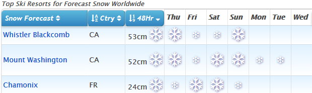
See where it's expected to snow this week...
EUROPEAN ALPS Austria The rate of snowfall has slowed a little in Austria this past week but it has still been coming down, more is forecast, and overall it's looking like a pretty good Christmas week this year with plenty of idyllic images of snowy chalets to be had across the country. Solden still posts the deepest base in the country at 2.7m (9 feet) and it is looking like one of the higher, westerly areas that's set to benefit most from forecast snowfall over the coming week. It and resorts like St Anton, Ehrwald, Obergurgl and Lech should have another 40-50cm by this time next week whilst for most others it's more like 5-15cm. France The snow is falling in France again after a quiet few days (the biggest 7 day total was at Cauterets in the Pyrenees with 47cm reported). It's expected to keep falling over the next 72 hours with the biggest accumulations expected on Friday and Saturday at many resorts – some could add 50cm ahead of next week. Currently Serre Chevalier in the southern French Alps has the deepest base in the country at 45-200cm (it's the first this winter to hit the 2 metre mark). Conditions are looking good pretty well everywhere now, with at least a metre of snow coverage on upper runs at most leading resorts and 100-155cm in Tignes-Val d'Isere for example – great coverage for Christmas week. Italy Italy remains a country divided with some fresh snow falling in the West – and more forecast there, but little or no snow in the Dolomites to the East, which have recently been hosting a whole swathe of World Cup racing in Alta Badia and Val Gardena. The mountains are white but coverage for skiing and boarding relies a good deal on the very impressive and extensive snow-making system. In the Aosta Valley and other western areas it's a different story with some fresh snow last week and more falling with up to 60cm forecast by this time next week at resorts like Courmayeur and La Thuile. Switzerland Swiss resorts got the best of the snow in the Alps over the past week and it's looking promising here for the week ahead too. Most areas are expected to get another 10-20cm of snowfall and quite a few as much as 30-50cm with the western of the country likely to see the biggest snowfalls – again particularly this Friday and Saturday. Verbier, along with the Portes du Soleil and Gstaad regions, are amongst those likely to see at least 40cm of fresh snow. Andermatt still has the world's deepest reported snow base a 4 metres and Saas Fee the second deepest swiss base at 2.5m, with neighbouring Zermatt third on 2.25 metres. Scandinavia Nothing sensational to report in Scandinavian snowfall this week but some modest 5-10cm gains since the weekend at a few of the region's leading resorts like Hemsedal and Trysil in Norway and Idre Fjäll in Sweden. So far most have bases in the 30-60cm bracket and perhaps 20-30% of their terrain open, ready to move it up a gear for Christmas next week. Pyrenees It's difficult to say at this stage which way the start of the season will go in Andorra and the Pyrenees. There was a 10cm snow fall in the area at the weekend but not a lot more in the forecast and temperatures at base level hovering around freezing. Most of Andorra's ski areas do have at least half their terrain already open as Christmas week nears and bases are at around 40-50cm on upper runs – so, in short, it's looking OK but not brilliant. Scotland Scottish hills finally turned white again on Saturday when snow fell across a wide area. Subsequent warm temperatures and rain have spoilt this cover on lower slopes to some extent but the tops remain white at time of writing. However the only areas currently open are the small tracks at Glencoe and The Lecht created by the two areas' new all-weather snowmaking machines. There is no news as yet on the likelihood of a third machine at Cairngorm being switched on. Eastern Europe There's been more snowfall across Eastern Europe with 5-15cm reported. Conditions are gradually improving with bases at Bulgarian areas now up to 50 – 70cm, the deepest currently at Pamporovo. Other areas in Slovenia and the Czech and Slovak Republics have also reported good snowfalls and here resorts like Špindlerův Mlýn may see another foot (30cm) of snow by Sunday. North America Canada Great conditions now across most of Canada with Whistler stealing the headlines after receiving seven feet (2.1m) of snow in seven days to Tuesday. There's no real sign of a slowdown in sight either with more 20-40cm daily accumulations forecast in to the weekend. The only issue is warmer weather still at lower elevations meaning not so much snow down below or at neighbouring, lower, ski hills in the region. Further inland though Revelstoke is being dumped on and there has been some snow, if not so much, in Eastern BC and in to Alberta. Ski areas over on the East in Quebec and Ontario are reporting great conditions too. USA Attention has again focused on the huge snowfalls in the Pacific Northwest of the US with Mt Baker reporting 8 feet (2.4m) of snow in 7 days up to Tuesday this week, and there's another 70cm forecast in the next 3 days, which would take the 10 day total past 3 metres/10 feet. It is, however, continuing to snow in many parts of the country where they're still celebrating the snowy October and November that got the winter off to a great start here. Alta in Utah has had a foot of snow in the past week for example, so has Jay Peak in Vermont, and both have more than a metre of snow lying. The only 'blip' are occasional complaints of wet, sticky snow at lower elevations in California, Colorado and Utah. One small, southerly ski centre in the former, Mt Shasta, recently closed again because of the impact of this on its snow cover. |
|