Messages posted by : admin
Gales at the top, light winds in the valley... we'll make that clearer! 8) |
|
Yes. You may not need to use them, but you must have them with you in case they're required (either for getting up, or driving down at the end of your stay). Regardless of the immediate forecast, you should always have chains with you if you're going to Val Thorens in the winter. If it is snowing on Sunday, the French police may well be out to stop anyone without chains from attempting to drive up (they do this, and it's a good thing!). If you do manage to get up without chains and it snows lots while you're there (as is forecast) then you might die on the way down and that would spoil your whole trip. Don't die. |
|
Yup, forecast has upped the snowfall considerably since yesterday (50cm+ on the cards) - may not quite be on the scale of the Alps this week but you're certainly looking good for the weekend. Probably will be enough to disrupt the roads at times but I don't know how vulnerable to the winds the lifts are; what do you reckon Brucie? |
|
Where are you seeing that? There's a fair old storm (heavy snow) forecast for the Alps but Andorra's not looking too dramatic; it's 5 days ahead so going to change but forecast is for anywhere between 5cm and 30cm next weekend and the forecast winds (for Andorra) don't look strong enough to worry the lifties? |
|
No worries; the transfer to your hotel in Lyon, after your flight's diverted, should be fine... :lol: Snow Storm Incoming Getting up to Alpe d'Huez might get interesting; still a week away and Sunday's looking stormy at the moment, but keep an eye on the forecast. |
|
Snow Storm incoming - January 16th 2018 onward
Started by User in Snow Forecasts and Snow Reports, 7 Replies |
|
|
Yep, here we go again... another major snow storm is about to bring big snows to a significant part of the European Alps over the next few days.
Expected to bring heaviest snow to the northern/western Alps (northern French Alps, Swiss Alps) it is a big one, and just about the entire Alpine region should see at least some snow. Tuesday (tomorrow) and Wednesday look like bringing the goods, with as much as 1 metre of fresh for an area covering the Chamonix Valley, the Aravis, Grand Massif etc., the Valais (Verbier and Zermatt) and surrounds. To the South and East of that area should see falls between 20cm and 50cm. However (you knew this was coming...) - strong winds will accompany the snow, particularly on Wednesday we think, so lift and road closures should be expected. After a lull on Thursday, it all looks like kicking off again on Friday with more snow expected from then into the weekend. This second band of snow should see less wind but may well cause a few transfer day issues - though with much less traffic than the Xmas/New Year changeover. If you're not aware, you can get a quick overview of which days it's going to snow (and where) from our country snow pages like French Snow Reports where you can see a table as below that you can sort by 48-hour (and 7-day) snowfall totals. 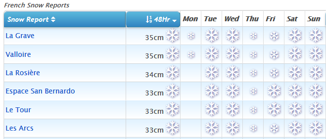
As always, the detail will change... but if it's anything like the last 2 storms then the 48-hour quantities may well ramp-up when the forecasts update through the course of today. :thumbup: Anyone heading out for next week, might be in for some fun... -) |
|
Now permanently detached - does that count as reclaimed by nature? Have they found what's left of it? |
|
|
J2Ski Snow Report 11th January 2017
Dawn breaks over a (very) snowy Tignes this morning J2Ski Snow Report 11th January 2018 Another huge snow storm, this time to the South of the Alps, leaves us struggling to say much other than "epic" or OMG... This Week's Snow Headlines - Up to 1.2m (4 feet) of snowfall in 4 hours on Monday-Tuesday in Western Italy. - Engelberg first ski area to report upper base more than 5m (515cm or 21 feet!). - All five Highland Scottish ski centres open. - Continuing record low temperatures in Eastern North America. - Fresh snow in Western US. It has been a week like no other in recent memory in the Alps after Storm Eleanor, a brief period of calm, and then some truly exceptional snowfall on the border area between France, Italy and Switzerland in the last few days. European skiers questioned if there could be such a thing as too much snow, as massive accumulations - accompanied by gales of up to 100mph at times, and occasional heavy rain - swept through the mountains. Many were advised to spend the latter half of last week indoors for their own safety at storm-bound ski resorts, particularly in the western Alps and at higher elevations. This brought the unwanted bonus of exceptionally high avalanche danger which led many ski areas in the Western Alps to close their slopes, at least on Wednesday and Thursday and in some cases through to the start of this week. Whilst the official risk level hit the maximum level 5 on the scale, resort workers commented that the danger was in fact off the scale and the French authorities declared a rare weather "Red Alert". Roads and slopes were either blocked by avalanches or closed due to the danger of avalanches and the danger level remains high - even though we appear to have entered a calmer period for the remainder of this week. There was fresh snow too in the Dolomites, Pyrenees and in Scandinavia whilst Scottish ski centres have managed to stay open since around Boxing Day thanks to consistently low temperatures and light winds. Across the Atlantic it remains exceptionally cold in the East and Midwest but there's some relief at the arrival of some decent snowfalls after a mostly dry start to the western season. In the Alpine Forecast Many resorts will be breathing a sigh of relief at the prospect of a pause in the snow and the forecast is for much clearer, settled weather for the next few days. So this coming weekend should see some fabulous conditions - but please see the warning below. As we move into next week, there will be more... snow! North and West Alps could see some (more) substantial snow around the middle of next week, with temperatures looking to run cold for the next couple of weeks. AVALANCHE RISK Avalanche risk levels remain very high over a wide area and this will continue for a while. Please be patient; exercise caution at all times and keep to the pistes until local authorities say it's safe. If going off-piste, carry avalanche safety kit (transceiver, shovel and probe) and do not ski alone. 
See when and where it's going to snow...
EUROPEAN ALPS Austria Most areas in Austria did not see quite as stormy conditions as further west during Eleanor's passage but a video of a wildly swinging chairlift at Montafon went viral showing the conditions were just as extreme here, and when resorts in the Aosta Valley were closed due to more heavy snow earlier this week, some in Austria were closed as more gale force winds blew in, even though they weren't getting a lot more snow. The Dachstein glacier with 4.3m of snow on it continues to claim the deepest base in the country (and one of the deepest in the world) but the Kitzsteinhorn is not far behind with a 395cm base. Obergurgl, which did catch 30cm of fresh snow from the edge of the latest snowstorms at the start of this week, is at 301cm on its upper runs. France More French resorts have passed the 3m base mark after the huge snowfalls of the past week. The Grand Massif region has hit 3.6m (12 feet), the deepest in the country, but most of the other regions have similar depths. Val d'Isere, which reported 1.1m of fresh snow in the first few days of this week, is at 3.5m. With exceptionally high avalanche dangers, access problems and other issues to contend with due to all the snow, it's likely resort managers are saying, "thanks very much, but that's enough now." The snowfall should indeed dry up during the remainder of this week allowing for several calm days to regroup when hopefully the avalanche danger will reduce and French areas can safely re-open terrain. Once that's all sorted it's looking like a great winter! Italy It's been a remarkable week for snowfall in Italy with the country's western resorts hit by Storm Eleanor and then more exceptionally heavy snowfalls at the start of this week. The Milky Way (Via Lattea) area reported an incredible 1.2m of snowfall in 4 hours on Monday/Tuesday. The ski area though – like many others – was wholly or mostly closed. Here the blame was not put so much on avalanche danger but on snow laden trees collapsing under the weight of the white stuff and falling on to ski lift cables. Cervinia meanwhile made mainstream news headlines after it was largely cut off by the huge amounts of snowfall there, leaving skiers stranded. It too closed its slopes. The snow has also been falling in the Dolomites which are enjoying their best season for quite a few years. Bases are in the 50cm-2m mark in the region with Cortina reporting 30cm in 24 hours up to Tuesday. Switzerland Swiss areas too have suffered the brunt of the storm and then, in the West of the country particularly, the second wave of heavy snowfall at the start of this week. Several ski areas were closed due to avalanche danger or logistical problems with operating. The global media got particularly excited on Tuesday when they learned Zermatt had been temporarily cut off, although they could not find anyone stuck in Zermatt who was terribly concerned about it; with rail links re-opening on Wednesday morning and pistes looking set to start re-opening too now the Matterhorn has re-emerged from the clouds. Engelberg has gone through the 5m mark on its upper slope depth – the first in the world to do so this year. Andermatt has the second deepest base in the country at 4 metres. As with the rest of the Alps, a lot of terrain is currently closed but bases have built so much it's looking good for the remaining three-quarters of the season, particularly in the near future once everything can re-open. Eastern Europe No real fresh snowfall reported in Bulgaria where cover remains thin at Pamporovo (35-25cm) with 10 of the 21 runs reported open. Borovets (55-80cm) however has most of its runs open. Conditions are not much different in Slovenia where Kranjska Gora recently hosted World Cup racing. It has a 40-70cm base and reports 16 of its 20 trails open. Scotland All five Scottish ski areas have been open this week, building a little on thin bases resulting from occasional snow showers over the past fortnight. It has rarely gone above freezing since Christmas in the Highlands, even down in the valleys, but there has been unusually steady weather conditions with few of the usual strong winds from the west that often plague the area with warm wet fronts. So skiers in Scotland have been able to enjoy some beautiful crisp, blue sky days through the Christmas/New Year holiday fortnight which provably means business levels are already above the total for the very poor winter last season. Pyrenees Andorra enjoyed some good snowfalls at the weekend with Grandvalira clocking up nearly 60cm (two feet) of fresh snow. Base depths in the country are now in the 1 to 1.5 metre bracket with most slopes open and conditions generally good. It looks like it will keep snowing, lightly, on and off over the week ahead. There were big snowfalls on the French side of the mountains too. On the Spanish side less snow but bases are good anyway – Formigal is up to 2.3m and reports all 87 runs open. Scandinavia Fairly good conditions across Scandinavia with decent bases reported throughout and most lifts operating and runs open. In Finland Ruka reported 10cm of new snow at the start of the week, it has all 30 of its runs open it says. The region's biggest resort, Are in Sweden, has a 92cm base and in Norway some ski areas have reported 15-30cm of fresh snow in the past few days with Roldal in the West of the country reporting Scandinavia's deepest base of2.5m. North America Canada Canada has seen some of its biggest snowfalls of the season over the past week with Red Mountain in BC topping the snowfall tables with 82cm (almost three feet) of snow in 72 hours since the weekend. There's been snow in the East too, where it has remained very cold, Mont Tremblant for example reported 35cm in 72 hours although its base is still reported to be around 60cm. The heaviest snow has been in the west, particularly BC, where most resorts report bases around the 1.5-2.5 metre mark but Massif du Sud in Quebec still claims the biggest base in the country at 266cm. USA The long awaited fresh snow in Western North America has greatly excited ski areas in Colorado and California. Mammoth reports 56cm of fresh snow and is still claiming the biggest amount of terrain open in the US at present (over 1,000 hectares). It's lower and upper slope base depths have also jumped about 55cm to 107-213cm. Aspen got 25cm, Snowbird 30cm but Steamboat is claiming the most terrain open in Colorado – about 80% of the max possible and much better than most of its neighbours. Snow conditions remain good in the East and MidWest thanks in part to the cold weather though, although this has caused areas to continue to have to close on occasion when it becomes too cold for humans to safely venture out or for machinery to safely operate. |
|