Messages posted by : admin
|
J2Ski Snow Report 11th April 2019
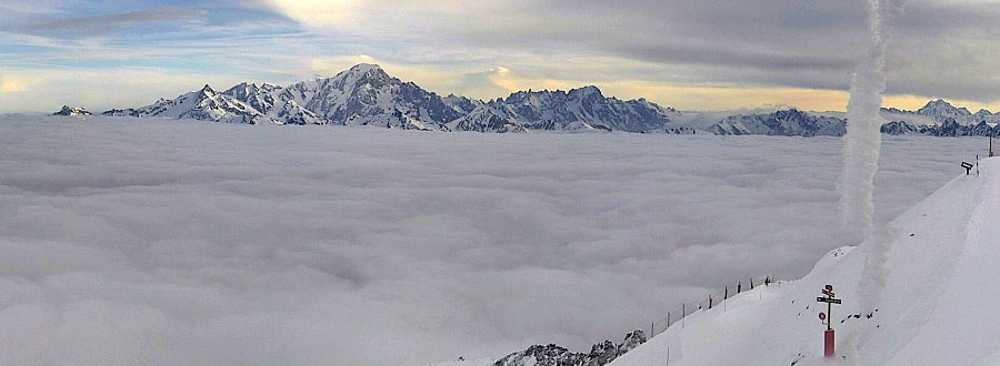
Snowy peaks above the clouds in Les Arcs, France this morning... More heavy snow in the Alps and Dolomites, with more in the forecast. This Week's Snow Headlines - 11th April 2019 - Forecasts correct, with massive snowfalls in Alps and Dolomites to start April. - World's deepest snow depth passes 7 metre mark for first time this year. - Ski resorts in Italy claim up to 206cm (nearly 7 feet) of snowfall in 72 hours. - Norway's Fonna summer glacier ski area opening for season this coming Sunday. - Ski resorts in Austria, France, Italy and Switzerland report up to 1m of snow in 24 hours. - Scottish ski areas re-open for a third time after heavy snowfall. The final month of the ski season for most northern hemisphere ski areas got off to an exceptionally snowy start with heavy snowfall across many of mainland Europe's mountain ranges, particularly the Dolomites and the Alps. More than a dozen ski areas reported a metre (40 inches) of snowfall in 24 hour periods between Wednesday and Friday last week, with some claiming 2 or 3 day accumulations of up to 1.8 metres (6 feet). So it was a powder skiing first weekend of April, albeit with the avalanche danger level going up from level 1 a little over a week ago to level 4, one below the highest. It seems almost everywhere got some fresh snow, including many resorts coming to the ends of their seasons. Most areas got at least 30-60cm (1-2 feet) but the biggest accumulations were reported from Italy and Switzerland. Engelberg said last weekend that, after a metre of new snowfall there, it had passed the 7 metre base depth mark up on its glacier, the first resort in the world to do so this season. In Italy, along with big snowfalls in the Alps to the West, the Dolomites were transformed with their biggest snowfalls of the season – rather ironically right at the end of the season for most, although ski resorts in the area say they do their best business with groomed sunny slopes anyway so perhaps they're not too frustrated by that. There was more snow in many areas on Sunday and conditions remain unsettled with ongoing snow showers in many areas, mostly light, but some bringing further big accumulations to higher slopes throughout this week. The avalanche danger increased to as high as level 4 ("high"), one below the maximum 5, in some areas after all the fresh snow. The Pyrenees has seen snowfall over a longer period with mostly light to moderate snow showers on and off over the last 10 days now adding up to more than 50cm for some areas. It has kept snowing in parts of Scandinavia too and in Scotland heavy snowfall at the end of last seek resulted in two areas that had previously closed due to the thaw re-opening. Across the Atlantic it has been rather less dramatic with no huge snowfalls to report and a rapid thaw underway in some areas. There has been some fresh snow at times, in Western ski states and in Quebec, Canada, but nothing more than 30cm in total. Despite the fact that the snow is falling more heavily now than it did in February and March in many areas time marches on and another swathe of ski areas ended their seasons on Sunday, including some big name resorts, and more than half are likely to have closed by the end of next Sunday. In the Alpine Forecast Generally clearer this week, giving some great skiing, but please be aware that some resorts have already finished their season and more will close this coming weekend - so do check openings before you travel! Next week will be warmer, with freezing levels above 2,000m at times, although with more precipitation so higher resorts and slopes should get quite a bit of fresh. 
More snowfall expected for The Dolomites, but please note many ski areas there are now closed.
EUROPEAN ALPS Austria Austrian ski areas tend to close earlier in April than ski resorts in the other big four Alpine ski nations and resorts in the Skiwelt, for example, were already closed before last weekend when some of the biggest snowfalls for several months hit the Austrian Tirol ... along with most of the rest of the country. The biggest accumulations were reported on the country's glaciers with 80cm for the Stubai, 90cm for the Pitztal and a full metre for Solden just in time for the weekend giving those areas that were still open a great last season boost and an excellent final powder weekend of the season. Austrian ski areas have seen more snow over the past few days since the huge dump at the end of last week, but this has been more in the 5-20cm range. France France enjoyed the fruits of the big snowfalls across the Alps at the end of last week with ski areas reporting up to 1.2 metres (4 feet) of new snow up to the weekend. The heaviest snow was initially in the Massif Central region then in the Southern alps with Serre Chevalier reporting a metre of snow on upper runs in 24 hours and Auron 1.2 metres over the three day period. It hasn't really stopped snowing this week though. After a weekend lull the snow has kept falling, just not quite so heavily. Val d'Isere reported 25cm in 24 hours to start the week and La Plagne 15cm on Tuesday, however since then skiers in many areas have reported glorious sunny conditions with the fresh snow and conditions best in the mornings. Apart from refreshing cover across the mountains the new snow has also bolstered lower slope depths in France making top to bottom skiing much more reliable in the run up to Easter. Italy Italy saw some of its biggest snowfalls of the season at the end of last week, and unusually there was snow right across the country's ski areas from Piemonte in the West to the Veneto Dolomites in the West. Italian resorts actually posted the biggest accumulations in the entire world for the past week too. Two small areas in Lombardy and Piemonte regions posted 1.8m (six foot) plus snowfalls in 72 hours up to Friday, far more than anywhere else. A number of areas also posted 80-100cm accumulations in 24 hours over Thursday/Friday including Monterosa, Cervinia and Val Senales – the latter two open to early May so are now in very good shape for their final 3-4 weeks of the season. There were similar totals for the weekend in the Dolomites with Alta Badia, Val Gardena, Arabba and other areas getting almost as much snow in 24 hours as they had all year to date. Switzerland Swiss resorts also saw some of the biggest snowfalls of the past week with Engelberg passing the 7 metre upper slope snowfall depth as mentioned above, and, Andermatt (which has the world's second deepest snow depth at 6 metres/20 feet) reporting the biggest 3-day accumulation in the country with 1.2m (four feet) of new snow, so there were great powder conditions here when the sun came out at the weekend. Beyond these big numbers most Swiss areas were offering great powder after 30-90cm snowfalls right across the country's mountains, and snow down to the valley replenishing top to bottom coverage, a rare treat this late in the season. Ski instructor Warren Smith in Verbier commented they were some of the best conditions there he had seen all winter. Scandinavia Most of the ski areas in Finland, Norway and Sweden are still open as the locals enjoy warmer temperatures and long days after the cold, dark winter. Temperatures have been staying mostly just below zero up in Lapland and northerly areas though so the snow quality here is about the best you'll find at present, other than the latest fallen snow in the Alps. No big new snowfalls to report in the past week, just some smaller 5-10cm accumulations to freshen things up over the last week. Pyrenees It has stayed fairly snowy, at times at least, in the Pyrenees with unsettled weather bringing repeated snowfalls and some powder days to ski areas in Andorra as well as on the French and Spanish sides of the mountains. Although a growing number of smaller and lower areas have now called it a day on the 18-19 season most of the larger, higher international destinations still have at least a metre of snow depth on their higher runs and all of their terrain open with most planning to stay open now to Easter weekend. Scotland Scotland's ski areas got their third re-boot of 2019 when around 50cm of snow fell on Scottish hills at the end of last week – for many the biggest snowfall of the season. Cairngorm had previously had to close all its slopes after a thaw the previous week but was able to re-open 16 runs for the weekend. The Lecht, which had just had a beginner area of machine-made snow available, reported good cover across all slopes. Only Glenshee remained closed. In the west Nevis Range and Glencoe which had both kept operating through the thaw thanks to deep snow bases and more fresh snow before the big dump also enjoyed a refresh of their cover. Typically for Scotland the snow has been followed by warm temperatures this week, so the runs still open at each area have diminished again, but at time of writing all but Glenshee still had some terrain open. Eastern Europe Most ski areas in Eastern Europe are now closed for the season but several dozen larger resorts are still operating and have seen some good snowfalls over the past week. Bansko remains open in Bulgaria and has benefited from some fresh snow on its higher slopes this week after others had already closed. There's also been snowfall in the Czech and Slovak republics although most ski areas in both countries have now closed for the season with Jasna reporting great conditions for this late in the season. North America Canada A week of varied weather in Canada as spring continues to take hold. Many of the country's resorts closed last weekend or will do next weekend but there's also been some fresh snow reported on both east and West sides of the country with the heaviest snowfall in the past few days in Quebec. Here Mont Tremblant reports its upper slope base depth has reached 5.9 metres, by far Canada's deepest. Le Massif posted the biggest snowfall of the week so far with 35cm on Monday/Tuesday. Over in the West, where resorts like Marmot Basin, Lake Louise, Sunshine and Whistler will stay open in to May there have been some glorious summer days and also some high altitude powder – Whistler reported 30cm of new snowfall at the start of this week and has a similar amount more in the forecast. USA There have been moderate snowfalls in the Western US over the past week, the heaviest falls through the weekend, and up in the northwest corner of the country. These were nothing like the accumulations of past months, but some areas received up to 50cm of fresh snow and most 10-20cm. California continues to dominate the American snowfall table with most of the top 10 deepest snow packs here. Squaw Valley's, the deepest in North America, got back up to 6 metres/20 feet after a foot (30cm) more snow there. Whilst most US resorts have closed already or will do at the end of this coming weekend, It and Mammoth, in second place with a 572cm (19 foot base) still have nearly three months of their extended season to run through to the start of July. |
|
Actually, apparently it doesn't (except Thursdays and Fridays) according to the info here :- https://en.tignes.net/holidays/getting-around/free-shuttles That does sound as if you need to be down by 5, but do check "on the ground" as the shuttle bus routes do get tweaked.
Result! 8) For more info, there are a couple of trip reports from April 2018 and December 2016 and (maybe for your next trip... -) ) Snoworks All-Mountain Ski Courses. |
|
|
It is forecast to be a little warmer next week but there is masses of snow above 2,000m and more to come this week so everything above the level of Tignes le Lac should be great. The "home runs" (Red and Blue options) back to Les Brevieres are likely to be slushy but you can always download on the gondola (slush can be fun if you get the timing right!).
To get up, you'll have to take the new gondola up from Brevieres to Les Boisses (which I think is now running reliably after some teething issues early in the season), then gondola up from Les Boisses for a choice of chairs to take you high enough to drop into Tignes le Lac. You've got a lot of Blue/Red choice just in the Tignes bowl, and the Tignes pass covers you for the "first drop" toward Val d'Isere (the limit of the pass is well sign-posted - so do pay attention to the signs!). You can travel round the whole bowl on Blues - easiest done clockwise, starting up the Toviere gondola from le Lac - which is great for giving young 'uns a sense of achievement. That said, there are some nice, long intermediate runs around the Bellevarde (first Val d'Isere mountain) and a big "Tranquil" area which is nice for easy cruising with beginners. Your call on the lift pass choice! There is a timetable for the Val d'Isere/Tignes shuttle at https://en.tignes.net/holidays/getting-around/la-navette-tignes-val-disere. That only appears to go to Les Boisses, and ONLY with the buses from 17:37 - which will be too late to catch the gondola down to Les Brevieres (which stops at 17:00 EXCEPT Thursdays and Fridays...). [Edited to add that the Les Boisses -> Brevieres gondola shuts at 17:00, except Thursday and Friday] Email the tourist office to be sure, or just ask when you get there! Should be a cracking week - enjoy! |
|
|
Forecasts are promising snow on-and-off for the next couple of weeks, so anywhere still open by then should still have good cover (assuming no heatwave to end April).
Tignes, Engelberg (which is today reporting 7 metres of snow up top!), Val Thorens, Hintertux should all be open through into May. And just seen that Cervinia have a free lift pass deal for a minimum 4-night stay from the 28th. |
|
|
J2Ski Snow Report 4th April 2019

A brief glimpse of the fresh snow in La Clusaz, France this morning... Heavy snow in the Alps, Dolomites and Pacific NW! This Week's Snow Headlines - 4th April 2019 - Huge snowfalls forecast for the Alps, Dolomites and Pacific Northwest. - Gstaad ends ski season on 31st March. - 40cm of snowfall for Scotland on Wednesday morning. - Snowfall in Australia, two months before 2019 season is due to start there. It's snowing in the Alps and the snowfall is forecast to get heavier in many areas through the rest of this week, meaning that some places may get as much as a metre of snow on their higher slopes by the weekend, and many should get 30-60cm of fresh cover. The snow isn't just falling in the Alps either, it started to fall earlier in the Pyrenees, although the snowfall is less intense here, and the Dolomites are due to see some of their biggest snowfalls since last autumn. It's snowing up in Scandinavia and Scotland too - a real return to winter almost everywhere. Of course, this fresh snow is arriving rather late in the season. Some smaller, lower altitude ski areas, including Gstaad, closed last Sunday and a larger number will end their seasons next Sunday. And whilst fresh snow is almost always welcome it's not really needed to see out the season even for those staying open to Easter or even later into spring, as most resorts are sitting on fairly healthy base depths anyway. The snowfall is expected to put up avalanche danger levels (which had been down at the lowest 1 or 2 during the benign conditions of the past week) to 3 (considerable) or even 4 or 5 (the highest levels) where the snow is heaviest. Over the Atlantic, smaller and lower ski areas began closing last weekend and a swathe more will join them this coming weekend or next. There have been moderate snowfalls here in quite a few areas, the biggest (up to 90cm) in the past week in the Rockies, particularly in Utah, at the weekend. The Pacific Northwest, including Whistler, is expecting some huge snowfalls through this week too, much like the Alps. In the Alpine Forecast Heavy snow is falling now across quite a wide area of the Swiss Alps, northern French Alps and the Dolomites; with some huge falls expected in some locations. Snow (and temperatures) will ease into the weekend, but Avalanche Risk Levels are expected to be at their highest at times so, as always, take local advice before leaving the piste! 
Huge snowfall expected for The Dolomites today and tomorrow... We're a little sceptical of the amounts forecast... but as we can't find a webcam not currently obscured by heavy falling snow, we'll give them the benefit of the doubt for now! 8)
EUROPEAN ALPS Austria The snowfall that arrived in the Western Alps on Tuesday began falling in Austria on Wednesday after a mostly dry and sunny week there. The snow is expected to be at its heaviest on Thursday and Friday before easing off over the weekend. Most of the country's ski areas are forecast to receive 30cm (1 ft) or so of fresh snowfall by Saturday, some as much as 60cm and a few as high as 90cm. Resorts in this latter category include Obergurgl and Solden in the Otztal region. A few dozen Austrian areas did close for the season already last Sunday and quite a large chunk more will do so on the 7th and 14th so they should at least end their seasons on a snowy note. For the more snow-sure areas open to Easter or into May and beyond the additional snow will be a great boost to already good base depths. France The snow started falling in France on Monday, again after a mostly dry, sunny week, with ski areas in the country's Massif Central (Besse Super Besse and Le Mont Dore) reporting the biggest snowfalls on Wednesday morning (around 15cm) with resorts like Avoriaz and Chamonix in the northern Alps posting 10cm accumulations. The snowfall continued on Wednesday but Thursday is the big day for snow across France with around 30cm (a foot) expected in many areas by Friday morning. The biggest accumulations are actually forecast for the southern Alps with Alpe d'Heuz and Les Deux Alpes as well as nearby Valloire and la Grave in line to receive up to 90cm (three feet) of snowfall which would certainly transform the recent spring-like conditions there. Italy Italy looks like it will see some of its biggest snowfalls of the season over the next 48 hours, the irony that the snow is arriving just as resorts prepare to end their seasons not lost on those that haven't had much of the fresh stuff this winter – not that there are too many of those. Like the rest of the Alps, it had been a dry and mostly sunny week until Tuesday when the clouds rolled in and the snow started falling with Alagna in Piemonte posting the biggest 24-hour accumulation (20cm) and Livigno in Lombardy reporting 12cm. But if the forecasts prove correct (which they're more likely to be now the snow has started falling and they're only looking a short way ahead) this is the tip of the snowy iceberg right across the country, with big falls of a metre (or more) of snow forecast from Cervinia in the North East to the Dolomites in the northwest, and much of the mountains in between. Switzerland Swiss slopes also enjoyed a sunny, clear week until Tuesday (for most areas) when the clouds rolled in and the snow started to fall. Brigels in the Graubunden canton posted the first accumulation of note with 15cm by Wednesday morning. But as with the other big four Alpine nations, this looks like the start of much bigger things to come with ski areas across the country likely to get at least 30cm accumulations here too. Those forecast to receive much more over Thursday and Friday include the two that already have Switzerland's and the world's deepest bases; Engelberg with 6.3 metres and Andermatt with 6 metres. They're likely to see about 60 and 90cm more respectively if forecasts prove correct. Scandinavia Plenty of fresh snow this week in Scandinavia with some of the biggest falls reported in Western Norway at coastal resorts like Voss and Northern Sweden up at Bjorlkiden and Riksgransen in the Arctic Circle. The latter is reporting a 4-metre base, the deepest in the region at present. Conditions are reported to be good too up in Finland where the weather has been sunnier with less fresh snow, but cold enough to maintain snow quality. Pyrenees Whilst the snow has been falling for 24 hours or so in the alps it has been going since the weekend in the Pyrenees, albeit with generally fairly light snow showers. They're due to continue on and off through to at least the weekend. Snow falling so far has amounted to 10-20cm on the slopes of Andorra with Grandvalira (Pas De La Casa, Soldeu) reporting almost all of its terrain still open but fairly honestly describing conditions below 1800m in altitude as 'slush' but higher runs as 'powder'. Scotland As with the Alps, it's a rapidly evolving picture in Scotland, but here the stakes are rather higher with the question of whether areas are open for Easter or not. At the time of writing Glencoe and Nevis range had about a dozen trails open between them with some good conditions on the slopes after 10cm of fresh snow on Tuesday. Cairngorm, Glenshee and The Lecht were closed (Other than a small beginner area at The Lecht using Snow Factory all-weather snowmaking) but Cairngorm reported 40cm of snow overnight on Wednesday and was assessing whether they could start to re-open terrain. Eastern Europe Bulgaria's ski season is drawing to a close with most of the country's ski area closing this weekend. Published base depths have dropped significantly at several areas, meaning Bansko, which will stay open to Easter, is now posting the country's deepest upper slope depth at 1.8 metres (six feet). It's looking like a snowy end to the season at several areas, particularly at Bansko, which is forecast to have received 50cm of fresh snow by the end of the week, the heaviest snowfall likely on Saturday. North America Canada It has been a fairly quiet week on Canadian slopes with little fresh snowfall and generally benign weather conditions. These have varied considerably however from temperatures nearing 20C in southern Ontario, where most resorts closed last weekend, to a return to sub-zero temps and snow in Toronto a few days later. Currently there's a lot of snow falling and still forecast in the Pacific Northwest (essentially BC) where forecast models project up to a metre of snow could fall on coastal ski areas like Whistler with the snowfall continuing inland to bring around 50cm of snow to resorts in central and eastern BC including Big White. USA The US has also had a 'quieter' week for snowfall than the last, although that's not to say there weren't some significant fresh accumulations, particularly in Utah over the weekend where up to a metre was reported (the most at Alta), and more recently smaller falls in California and Colorado. Some smaller ski areas have closed down for the season already and some of the big names including Crested Butte and Jackson Hole are due to end their seasons this Sunday too, despite having deep bases and fresh snow cover, it's just how it has always been there. There's little fresh snow in the forecast, just small to moderate falls in the West that may add up to 20cm more by this time next week on slopes in Colorado, California and Montana, 40cm up at Alyeska in Alaska. |
|
|
J2Ski Snow Report 28th March 2019
Ax 3 Domaines, in the French Pyrenees, last week... Mostly Spring but with some good snowfalls in a few lucky locations! This Week's Snow Headlines - 28th March 2019 - Heavy snowfall in Vermont and along the US East Coast (up to 90cm/3ft last weekend). - Up to 45cm/18in snowfall in 24 hours in the Eastern Alps. - First ski areas end 18-19 seasons in Connecticut, French Pyrenees and elsewhere. - Up to 60cm of fresh snow in the past 7 days at some ski areas in Norway. It's been another mostly dry week on the ski slopes of central Europe - in the Western Alps at least. There was some fresh snowfall in Austria/Eastern Switzerland, southern Germany and the very northern fringes of Italy at the start of the week, with some areas reporting as much as 30-45cm of fresh snow on higher slopes, but for most the numbers were much less. There's been a little snow in the Pyrenees too and even down at Europe's most southerly ski area, Sierra Nevada in Spain. But mostly it has been another week of classic spring skiing with the snow freezing hard overnight then softening through the day – especially lower slopes as temperatures climb above zero. That said, it has been a little colder than the week before in many areas. In many areas this week temperatures have stayed below zero (down to -15C or even lower at times) above 2000 metres and have been dropping back below freezing overnight at resort level too. The most snow in Europe has been falling in Scandinavia, for the second week running, with some resorts in Norway posting 60cm in total over the past week, a few getting more than 20cm in 24 hours for some Spring powder days. It has been snowing too in Scotland but alas also thawing between cold spells so the overall picture, in terms of open runs and ski centres, has deteriorated from the season high last week. North America has had a snowier week with the biggest snowfalls initially on the East Coast at the weekend with some resorts getting three feet of snow in Vermont and most others in the region getting at least a foot of fresh. Since then the focus for fresh snow has moved to the west coast with more heavy snowfalls in California in recent days, as well as in other western states, building on what are already some of the deepest snow bases in the world this season. In the Alpine Forecast Although there are hints of a breakdown and a possible return to snow, in the long-range forecasts, it looks like more of the same (Spring skiing) for the next week or so at least. Fun in the sun! Enjoy... 
See where it's expected to snow this week...
EUROPEAN ALPS Austria Austria saw widespread snowfall across the country to start the week with temperatures dipping back below zero. Most areas got 5-15cm of fresh snow but Saalbach, St Anton and Montafon all reported 30cm in 24 hours to Tuesday morning. Then the sun came out again for some great spring powder. A number of low altitude Austrian areas will close for the season this coming Sunday so they're going out with a bit of fresh snow at least. The glacier areas which stay open to May, June or even longer (all year in Hintertux's case in fact) got more of the fresh snow and with most having at least 4 metres of snow lying it looks good for the late spring skiing season ahead. France It has been a second dry week on French ski slopes with some glorious sunny weather on the slopes and – as with most of the northern hemisphere – spring-skiing freeze-thaw conditions and the best snow on higher runs. The country's purpose-built ski areas have a bit of an advantage at this time of year with the snow still lying at least a metre deep at resort level for many and staying in good shape top-to-bottom all day. Some of the classic, lower areas with slopes 500-800 metres lower down the mountain are having more of a battle maintaining cover. There's been a bit of a thaw from a week ago but most resorts still have plenty of snow left with the Paradiski region posting marginally the deepest upper slope depth at 3.3 metres (11 feet) but really most of the country's leading areas reporting good depths, generally above 2 metres on upper runs. In the Pyrenees, where some resorts have struggled for consistent snow cover this winter, Formigueres closed on Sunday, a week early, saying it had lost its battle to maintain enough snow that was worth skiing on, ahead of the originally planned closure date this coming Sunday. Italy A similar picture again in Italy with just some light snow falling at times on higher slopes along the country's northern border with Switzerland and Austria. Otherwise it's a mostly sunny picture with the season winding down at the country's lower elevation ski areas, some of which will be closed from this Sunday. On the other hand, a dozen or so Italian areas plan to stay open into May, and some beyond, with Passo Stelvio (which opens from May to October) looking good for the start of its summer season at least. Most Italian areas do have plenty of snow to see them through to their season end anyway, whenever it may be, only a few like Alpe di Siusi with just a few centimetres on its lower slopes and less than 40cm up top look like they're struggling if their published stats are correct – but equally they still report every run open! Switzerland Swiss slopes are in a similar position to the rest of the Alps – spring conditions, colder this week than last, particularly up high, and some light to moderate snowfall at the start of this week (with more forecast at the weekend. Davos Klosters reported a 5cm accumulation on its upper slopes on Sunday and then on Monday there were more significant falls, with Laax posting the biggest accumulation in Europe for the past few weeks – 45cm in 24 hours. No other area posted anything like as much as that though. Swiss ski areas continue to post the world's deepest bases at Andermatt (6m/20 feet) and Engelberg (6.2m/nearly 21 feet) and most of the country's big resorts are posting healthy snow depths on their upper slopes. Cover down at resort level is getting more marginal though and is at completely the opposite extreme. Engelberg has only 10cm for example, and Zermatt, with more than 2 metres of snow on its year-round glacier slopes, has only 26cm lying on its home runs down into the village. Scandinavia Until the snowfalls in the Alps at the start of this week, by far the most snow in Europe over the last week (and indeed the one before that) had been falling in Norway and Sweden. That continues to be the case to some extent with heavy snow expected up in Riksgransen up in the Swedish Arctic later this week, with up to 50cm forecast there by Friday. Scandinavian ski areas as a whole come into their own at this time of year, particularly to the north, with the longer, warmer days at these northerly latitudes but temperatures still generally cool in the days without the rapid afternoon softening of the slopes common in the Alps. Pyrenees There was a little fresh snow in the Pyrenees at the weekend and even as far south as Sierra Nevada down on the Mediterranean coast but overall the trend for full-on spring is the dominant one and at least one ski area in the French Pyrenees, Formigueres, decided to give up the battle against mother nature last Sunday, closing a week earlier than planned. Depths remain good in Andorra however where almost all trails remain open with top to bottom skiing still possible and up to 2 metres lying on upper slopes. Scotland Another roller-coaster weather week for Scotland's long-suffering ski areas this season. Having re-built bases lost in the record-warmth February thaw over the first three weeks of March, a week ago all five Scottish Highland ski areas were open with a season-best 70 runs open between them. By the weekend though a fresh spell of warm weather wiped out a lot of the cover with the result that Cairngorm and Glenshee now have no skiing open and The Lecht just has the all-weather machine-made snow. There was fresh snow in the west on Sunday with more flurries since and Glencoe has been almost fully open this week and Nevis range has a good selection of runs too. Eastern Europe Temperatures have dipped a little over the past week in Eastern Europe with some fresh snow in the Tatra mountains of the Czech and Slovak Republics. Bulgaria too is having a snowy week and in fact, looks like this will be the snowiest week for a month or two there if the snow keeps falling as forecast. Totals look like they may be as much as 50cm of fresh snow by the weekend across the country's higher ski slopes if so. North America Canada Changeable conditions in Canada with some good snowfalls in the Quebec region around the weekend bringing up to 40cm more snowfall to resorts in the East. Tremblant has the country's deepest base still at 5.7 metres. Further west it has been quite snowy in recent days in BC and western Alberta with 10-30cm of fresh snow falling and there's a similar amount in the forecast up to the weekend. Whistler is forecast to get 30cm of snowfall by Saturday. USA A return to snowy weather in the US over the past week, initially with heavy snow on the East Coast at the weekend – which saw some ski areas in Vermont report as much as 90cm (three feet) of new snow in 72 hours, and heavy snow almost everywhere in the region, then more recently a return to snowy conditions in California after temperatures had a dew fairly dry weeks. It's still snowing here but it's likely some centres will see another 60cm (two feet) of snow by the weekend. Until next week, enjoy the Spring! |
|
|
Welcome... you need to give us a bit more to go on! What level of skier are you? where in Italy? what sort of skiing are you looking for?
There are literally hundreds of ski areas in Italy, but you could start with J2Ski's guides to Italian ski resorts. Hope that helps, but it's difficult to advise without knowing more about you. |
|
|
Sounds like a good trip, and interesting about the bottlenecks moving to the older lifts... I'd imagine/hope they knew that was likely to happen, but the bus is a good fallback.
How long did that take? ...vaguely thinking about an Easter(ish) quicky if the snow comes in again (as is looking possible). |
|