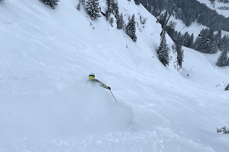
Powder on the pistes (demonstrated here by Admin Junior), La Clusaz, France today!
Powder in the Alps, fresh snow in Canada and spring takes a hold in the Rockies.
The Snow Headlines - March 26th
- More spring snowfalls in the Alps give a nice refresh between spells of spring sunshine.
- Eastern US sees up to a foot of snow as base level temperatures in the Rockies reach +20C.
- Avalanche danger level peaks in the Alps as upto 50cm/24 hour spring snow dumps reported
- Cold and fresh snowfall across Canada.
- Bulgarian ski areas see some spring snowfall up high giving a late season boost.
- Cairngorm and Gencoe keep hopes of Easter skiing in Scotland alive.
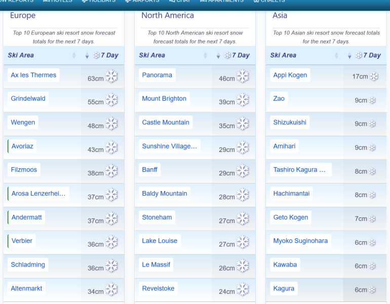
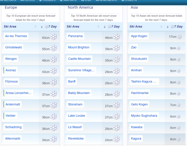
Snow forecast for the Alps, America and Japan.
Re-publication :- the J2Ski Snow Report Summary, being the text above this line, is free to re-publish, but must be clearly credited to www.J2ski.com with text including "J2Ski Snow Report" linked to this page - thank you.
World Overview
Spring has now arrived in full, with conditions across the Alps and Pyrenees largely matching seasonal expectations: bright spells, freeze–thaw cycles, and generally stable snow. Early‑week snowfall refreshed higher slopes with up to 50cm, while southern Europe also saw top‑ups, including 10–20cm in Bulgaria. Scandinavia remains the continent's most reliably wintry-feeling region despite it being April next week, with Western Norway receiving 10–30cm and Lapland holding steady subzero temperatures.
It is now snowing again in the Alps and the wintry weather is expected to continue on and off through into the start of April next week. The only downside of that is avalanche danger levels jumping from a low-ish 2 to a high/very high 4-5 on the danger scale in much of the central and western Alps.
Across the Atlantic, the US again shows a sharp west-east contrast. The Western states are experiencing exceptionally warm March temperatures, pushing some resorts toward early closures. In the East, colder air persists, as has been the case all season, maintaining firmer surfaces and occasional snowfall - up to a foot (30cm) in fact last weekend. Canada meanwhile stays consistently wintry from the Rockies to Quebec.
A similar picture in Japan with northerly Hokkaido leading with the deepest bases and fresh weekend snowfall, while Honshu's major resorts shift into classic spring conditions with thinning lower slopes.
Europe
Austria
It's been a mixed week in the Austrian Alps, with temperatures swinging from –10 °C to +10 °C depending on altitude and time of day. Rain, sleet, snow and shifting cloud cover have all featured, while snowfall totals have been modest: Obertauern saw one of the largest top‑ups with around 10 cm at altitude, Ischgl posted 15cm.
Most Austrian resorts will close over the next three weekends and one of the first of the well-known resorts, St Johann in Tirol, did so last weekend. Base depths remain well below average across the country, though major centres are still largely open with The Arlberg posting the most, more than 90% of its slopes still open.
A cold front has now moved in and begun delivering wintry weather which is expected to continue on and off for the coming week. Lech-Zurs posted the heaviest fall in the first 24 hours to Thursday, with a 45cm accumulation.
France
French ski areas enjoyed sunshine late last week, with freeze–thaw cycles shaping conditions. A shift arrived as the new week began, bringing fresh snowfall to higher elevations in the Alps.
Chamonix recorded the world's largest weekend total with 40cm, while Alpe d'Huez posted 25cm taking its base back up to the 4m mark, Europe's deepest. French resorts continue to hold some of the planet's deepest upper‑mountain bases, with Les 3 Vallées still over 95% open.
Wednesday saw a big temperature drop and then snowfall right down to valley floors, making Thursday a powder day with accumulations of up to 50cm reported. The snowfall will continue into the weekend with more expected at the start of next week too.
All this means it's looking good for Easter and April. Colder air has returned again, promising further significant spring snowfall for high terrain.
Italy
Italian ski regions picked up fresh snowfall earlier this week, even as the spring melt forced many smaller, lower‑elevation resorts to wind down; roughly a third have now closed. Larger destinations, however, remain in solid shape heading into Easter.
Alagna and Alpe di Mera each posted the biggest accumulations through the weekend, with a 30cm total reported on Monday. Cervinia reported 20 cm.
Freeze–thaw cycles are preserving cover on higher slopes, especially on shaded north-facing aspects despite mild afternoons. A colder, more unsettled pattern is arriving with summit temperatures forecast to drop to –15 °C or lower and renewed snowfall at altitude.
Switzerland
Switzerland has mirrored the wider Alps with a mostly mild, bright spell, though overnight freezes continue to lock in a firm freeze–thaw cycle. Weekend snowfall helped refresh slopes, with Crans‑Montana seeing the most reported, around 20 cm on Sunday.
The 4 Valleys still offers the country's broadest lift‑served terrain with over 300km of slopes still skiable there, while Saas‑Fee retains the deepest cover.
A fresh spell of wintry weather has arrived in the country in the past 24 hours with high terrain at resorts like Zermatt, Saas‑Fee and St. Moritz dropping back to –10 °C and fresh snow falling to low elevations. 24 hour totals to Thursday hads already reached 50cm at some resorts including Adelboden and Engelberg with more forecast later this week and again after the weekend.
Scandinavia
Scandinavia has stayed largely dry over the past week, aside from Western Norway, where persistent snow showers have delivered 10–50 cm of new accumulation. Famously powdery Myrkdalern topped European snowfall totals in Tuesday with a 35cm 24-hour accumulation.
Temperatures remain on the colder side, helping preserve surface quality, though the southern half of the region is seeing daytime freezing levels creep steadily uphill as spring edges in.
Pyrenees
Spring conditions across the Pyrenees over the past week, producing widespread freeze–thaw cycles and increasingly soft snow on lower pistes. Afternoon temperatures are pushing well into the mid‑teens in many valleys, while upper slopes dip just below freezing overnight before climbing steadily through the day. The ongoing mild spell is speeding up melt on sunnier aspects but a return to colder, snowier weather in on the cards for the next few days.
The big resorts including Andorra's Grandvalira (Soldeu, Pas de la casa etc) and Spain's Baqueira Beret remain close to fully open whilst France's Cautrerets has one of the world's deepest bases at 4m.
Scotland
Scotland has had another week of wild weather with the two centres that are still offering lift-accessed snowsports this season, Cairngorm and Glencoe, spending several days stormbound after some ideal conditions last weekend. Cairngorm is down to about a dozen runs open, but it and Glencoe, which has a handful of trails suited to good intermediates and above on its upper mountain, both report fresh snowfall on higher slopes this week.
Eastern Europe
Light snowfall has freshened higher slopes in Bulgaria, Romania and some other Eastern regions, but the reality is that most eastern areas have enjoyed long spells of sunshine. Altitude now makes the biggest difference: low‑lying hills are reaching the mid‑teens, accelerating melt and as of the start of this week, more than 90% of them have closed for the season.
The big names remain open for a few more weeks though and are still seeing overnight lows to around –5 °C, creating freeze–thaw cycles that help preserve cover. Bulgaria's Bansko and Slovakia's Jasná lead, each with 90% of their terrain open still or more. Spring conditions dominate though, with softening snow each afternoon.
North America
Canada
Winter still dominates most Canadian ski areas, with both western and eastern regions holding onto cold temperatures and regular snowfall. The West saw a swing from mild weather to a sharp cooldown, bringing new snow across the Rockies.
Lake Louise delivered one of the world's standout weekend totals with 32cm, though the warm‑snow mix briefly heightened avalanche danger around Banff. B.C.'s Revelstoke continues to boast Canada's deepest major‑resort base.
Out east, subzero temperatures returned, preserving widespread terrain and keeping Quebec, Ontario and the Maritimes firmly in late‑season winter conditions still.
USA
A sharp west–east divide has shaped the past week in the US once again. The West has slipped deeper into unseasonable warmth, with California, the Pacific Northwest and the Rockies all seeing temperatures far above average. Many base areas have surged into the high teens and even 20s Celcius, prompting some early closures and rapidly shrinking terrain at those resorts trying to stick it out. Nights have stayed mild, accelerating thawing and leaving spring‑like snow by midday.
Meanwhile, the Eastern US has held onto colder air. Higher elevations in New England and the northern Midwest picked up up to a foot of snow, with summit temperatures staying below freezing.