GFS Ensemble 14-Day Forecast - Geneva - Updates every 6 Hours

Topic Locked
Login to Create or Answer a Topic
Jan 18, 2007
 2653 Posts 
This graphic from WetterZentrale shows the predictions of various runs of the GFS (Global Forecast System) models, for Geneva, over the next two weeks.


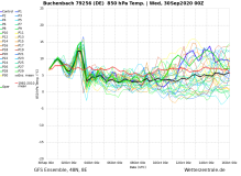
The upper set of the lines are the predicted temperatures (left-hand axis), in Geneva, by the various runs, and the lower set of lines are the predicted amount of precipitation (right-hand axis - rain in mm/snow in cm).

The bold white line in each set is the average predicted by all the runs.

This graphic is produced by and is the property of the frankly awesome WetterZentrale site - who provide a fantastic array of information for the technically-minded (in German).
The Admin Man
  Edited 7 times. Last update at 20-Oct-2011
Topic Locked

Change Forum

J2Ski Login

Username:
Password:
Remember Me
I lost my password

Not a Member?

Get FREE Snow Reports by e-mail.

The Wigglies!

GFS Ensemble Forecasts for Geneva

Using the Forum

E-mail Notifications

Posting Pictures & Youtube Vids

View the J2Ski Members List.

The views and opinions presented in the J2Ski Forums are solely those of their respective authors and do not represent those of J2Ski Ltd. Objectionable Content may be notified by sending a Private Message to Admin.