Messages posted by : admin
Sounds like you had a peach of a season Brucie! Have a good journey home. |
|
|
As we head toward Easter, it's warm in the valleys but there's still snow coming up high.
Top 100 Snowiest Ski Areas Worldwide 
Yes, it melts quickly down low, but it was still falling in Les Orres - France this week This Week's Snow Headlines - Up to 1.4m of fresh snow reported in Western Italian Alps. - Mt Baker nears 20m of snowfall season-to-date, believed to be most in the world. - Snowy weekend in the Pyrenees brings up to 50cm of fresh snow. - More than a metre of snow in southern Colorado. - Up to 60cm/two feet of fresh snow over the weekend in the French Alps. The Spring feeling that has been dominant in the Alps for most of March (and indeed February) was interrupted, at least on the western side of the mountains, by a return to winter over the weekend which saw some higher slopes receiving up to 1.4m of fresh snow over three to four days. The sun is out again now and it's freeze/thaw conditions, with temperatures mostly above freezing below 1500m, and generally below freezing above. It's the start of April this weekend and that means the beginning of the end of the season for the majority of Northern Hemisphere ski areas. For some in the South East of central Europe's mountains it seems that end can't come soon enough as they struggle to stay open, for others, further west, it has been at least an average and even in a few cases a good snowfall winter. The past week has also seen some fresh snow in the Pyrenees with up to 50cm of new snow reported on the French side, and it has also kept snowing in parts of Western Norway - the snowiest part of Europe in March. Across the Atlantic there's been snowier weather again on the western side of the continent. In the Forecast Spring continues to develop in The Alps, with a less snowy week ahead forecast - with plenty of sunshine. That said, there will be some scattered snowfall but with a snow line generally around 2,000 metres. With substantial bases still at altitude, despite the thaw lower down, higher resorts are generally in great late-season condition. Going Skiing? Please upload a Photo Snow Report! If you're in the mountains, please show us the snow! Check Snow Reports from Ski Resorts for a quick and easy way to upload pictures, straight from your phone.
The Alps Austria Despite hopes of snowfall last weekend, little or no snowfall has been reported across Austrian ski slopes for the past week and instead temperatures have been reaching double digits above zero at low lying resorts like Kitzbuhel, so that's not a winning combination for maintaining snows depths. But then it is the start of spring and many Austrian resorts are among the first of the big name centres to start to close for the season, in the first half of April, so there's not much time left. Set against that Austria also has more glacier ski areas than any other and base depths on the slopes at resorts aiming to stay open to May, June, July or beyond are pretty healthy at 2-3m on upper runs. St Anton, which stays open to the start of May, has a good 50-200cm base, Ischgl, which does likewise, is reporting zero at resort level, 110cm up top. There's little snow expected in Austria in the coming week. France Sunshine is the order of the day across French ski areas at present after a snowy weekend which saw skiers and boarders in resort enjoying some fresh powder at the start of the week. This being the start of spring the freezing point continues to move up the mountainside but above around 1500m it has been staying close to or below freezing meaning that lower traditional resorts are getting sticky in resort although higher up it has been much better. The weekend snow fall totals were typically 20-40cm although some resorts reported as much as 60cm (two feet) of fresh snow (Espace Killy). There was 50cm+ at Val Cenis (celebrating its 50th birthday), Vars and Risoul and Bonneval – which also reports the deepest base in France at 3.1m (10 feet). Generally slope depths remain good as we enter what is, for most, the last month of the season. The vast majority of French resorts have more than 1m of snow on upper slopes, many double that. In resort most have 40cm or more with Montgenevre posting the most impressive base at 1.5-2.5m. Italy Resorts on the western side of northern Italy – which have reported perhaps the most snowfall in winter in the Alps - continued their snowy season with up to 144cm (nearly five feet) of snow reported over the weekend (at Macugnaga). Other resorts in the area claimed 30cm (Milky Way) to 90cm (Monterosa) in the same period. The fact that the snow was best up top was reflected in the stats from Macugnaga though showing it still only has a 20cm base at resort level despite getting all that snow. Its base is however 2.4m at the top of the slopes. Again following the season-long pattern there was by contract little-to-no snow in the Dolomites, with Cortina posting the best accumulation there – 10cm. Bases here remain thin (5-30cm in Alta Badia) as they have all season with 2-5 weeks of 2016-127 left. Some more snow is expected in the West over the coming week, little or nothing in the Dolomites. Switzerland Western Swiss resorts too have seen some big snowfalls with Andermatt's 1.2m (4 feet) of snow over the weekend the biggest reported. It's 3.8m (nearly 13 foot) base is now the second biggest for a major resort in Switzerland and Europe behind Gstaad which has a metre more at 4.8m on its upper slopes. The Jungfrau, Engelberg, Leysin and Zermatt reported 20-30cm of new snow and Saas Fee 70cm, but the other areas reporting snow were mostly in the 5-10cm bracket and two thirds of Switzerland's leading areas didn't report any new snow. Lenzerheide, with 0-60cm of cover, has the thinnest base of the big name centres. Some more snow may fall in the next week but for most areas not much. Scotland Scottish ski areas did receive a few inches of fresh snow late last week but that was followed by three straight days when temperatures in the valleys got up to double figures. So Glenshee and The Lecht remain closed for snowsports as they have for much of the season; Nevis Range and Cairngorm each have a handful of their 35 runs open with thin cover on upper runs and Glencoe has half of its 20 runs available. Pyrenees The French Pyrenees posted some impressive snowfall figures over the weekend with several areas reporting 20-30cm of new snow for two days running. There was less new snow (10-30cm) in Andorra except at Soldeu which says it has had 80cm of fresh snow since last week. Bases are slowly diminishing though but remain fairly healthy at 1-2m. There may be similar snowfalls in the week ahead if forecasts are correct. Scandinavia Western and northern Norway continues to see copious fresh snow with up to 60cm in the past few days at some areas, Voss reporting 29cm and the best base of the bigger areas in Scandinavia at 1-1.9m. Other centres typically have 70-130cm bases and haven't reported much fresh snow. Are in Sweden (75cm) base reported 25cm of snow though, whilst the big resorts in Finnish Lapland just got 3-6cm more. Eastern Europe There have been a few centimetres of fresh snow in Bulgaria and there's more in the forecast. Bansko and Borovets continue to look good with 1-1.5m of snow lying, the base seems to be thinning fast though at Pamporovo with 30-50cm. Elsewhere Jasna has 20-40cm of snow and Kranjska Gora in Slovenia appears to have called it a day on the 2016-17 season and closed for the season. North America Canada Another fairly snowy week in Canada with resorts in the west of the country reporting 30-75cm of new snow (the biggest fall at Whistler) and in the east up to 30cm – at Mont Ste Anne. Bases remain good right across the country – generally in the region of 150-350cm, with only Tremblant in Quebec and Mount Norquay in Banff just below the metre mark. Mont Ste Anne has suddenly dramatically reduced their 4m+ 'deepest base in Canada' claim they've had for the past few months to a more feasible 1.4m so there has either been a cataclysmic thaw or someone has noticed they've been typing the wrong numbers in. Whistler's 345cm upper base is now the country's deepest. USA The season is looking snowy to the end in Western North America where Telluride has had more than a metre of snow and most other Colorado resorts 30-60cm of snow. In Utah it has been closer to 60-90cm. Further west there's been loess snow in California but the bases here are still reported at 6m+ (Squaw Valley) and 8m+ (Mammoth), the deepest in the world, although Mt Baker to the north in Washington State says it has overtaken Mammoth, after a snowier March than further south, in terms of seasonal snowfall and has now passed the 19m mark. A few inches more fresh snow in the East too where bases are in the 60-120cm area so should be good to see out the season. |
|
Snow Reports by e-mail - New Ski Resorts
Started by Admin in Snow Forecasts and Snow Reports, 85 Replies, discussing Morillon and Sölden |
|
We don't at the moment, but should be adding it in the next day or two. 8) |
|
|
Spring gets a grip in the Northern Hemisphere, but there's more snow coming for the highest slopes.
Top 100 Snowiest Ski Areas Worldwide 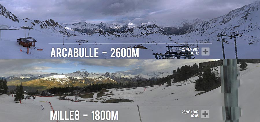
It's Spring, but lots of snow above 2,000m - Les Arcs, France this morning This Week's Snow Headlines - Norway's Voss resort reports 20cm or more of fresh snow for each of 7 successive days. - Base depth drops at Europe and North America's snowiest resorts. - 90cm/3 feet of snow for Zugspitz glacier. "Warm and wet" is the rather depressing message for the start of spring from ski areas from the Alps to BC in Canada and even Japan. Of course it is the start of spring, and widely varying temperatures and winds meant that last weekend's snow added little to base depths where it did fall. Overall, it has been a relatively snowless week across the world, with very little new snow in North America (comparatively) since the big snowfalls in New England a week ago. That said, Voss, in Norway, still managed to report 140cm of new snow, falling evenly through the past week, to top the snowfall table, with Germany's Zugspitz glacier adding three feet (90cm) of snow in second place. Most other areas have had 30cm or less. In the Forecast The Spring rollercoaster is going to continue for the next week, with a bit of everything - weatherwise - thrown into the mix. A few locations (e.g. Zermatt) will see heavy snow at altitude today or tomorrow, with a snow line generally around 2,000m. The Western Alps are going to be warm through this coming weekend, with lower temperatures to the East (albeit still above average). The beginning of next week sees a 10C drop in temperature, however, coinciding with a further band of precipitation which may bring snow briefly down to mid-altitude. So, good Spring snow conditions (and deep bases) at high altitude and thinning, wet, snow down low. Going Skiing? Please upload a Photo Snow Report! If you're in the mountains, please show us the snow! Check Snow Reports from Ski Resorts for a quick and easy way to upload pictures, straight from your phone.
The Alps Austria Austria didn't really get the snow it was forecast over the weekend and many skiers were complaining it was too warm on lower slopes for skiing and boarding to be a whole lot of fun. Just a few areas reported 10cm of snow, generally on Saturday, rather than the 30-50cm expected. The Kaprun glacier, with 90cm of snow on its lower slopes and 2m up top, reported the biggest accumulation of fresh snow – 20cm, so it's in pretty good shape for its spring season and the country's other glaciers also look pretty good – Kaunertal with the deepest base in the country at 3.4m. The lower slopes on some lower resorts in Austria are not looking quite so good though. More than half of Austrian areas now say they have less than 40cm on lower slopes and a growing number – including Ischgl and Mayrhofen, say there's nothing left in resort. A few like Igls and the Skiwelt don't have too much on upper runs either – 30-45cm. More snow is forecast later this week but it's looking patchy. France A similar picture in France, although here there was little snow forecast. It's has been warm, sunny and sometimes sticky at lower elevations, higher slopes are in better shape. But it's essentially 'spring skiing' across the board. Snow depths are looking slightly better than in Austria with only Chamonix and Vaujany saying they no longer have any snow at resort level, most areas have at least a foot still at the base of the slopes and over a metre higher up. The Chamonix Valley, Grand Massif, Valfrejus and Bonneval have the biggest numbers of 2.4-3m (8-10 feet) lying on upper runs. Italy Italy has some of the most promising snow forecasts for the end of this week with 30-60cm expected at altitude on Thursday/Friday at resorts in the west of the country. Snow is also expected in the Dolomites, just not so much and perhaps not so soon. Conditions continue to be best in the west with up to 2.23m of snow lying in the Aosta Valley whilst the Dolomites continue to rely on machine made snow to stay open and bases are much more marginal with most in the 10-50-cm bracket. Switzerland Swiss resorts have also been largely snowless for the past week with just a handful of resorts reporting 10-20cm of fresh snow. Gstaad, which last week posted the deepest snow in Europe by some distance at 4.9m was one of the few beneficiaries but despite reporting 20cm of fresh snow, a new measure of its upper slope base depth reveals its now down to 4m. Samnaun also claimed 20cm, Davos and Verbier 10cm and Zermatt 5cm. The number of Swiss resorts reporting now snow at resort level has grown with Adelboden and Jungfrau resorts Grindelwadl and Wengen joining Crans Montrana. Higher Swiss resorts are in a similar position to France with mostly good depths of 1m+, and in several cases 2-3m. Swiss areas are also amongst those expected to get the most fresh snow in the next few days and, possibly, next week. Up to 40cm is expected in the next few days at resorts including St Moritz and Murren with potentially more on higher slopes at Saas Fee and Zermatt. Scotland No real respite for Scotland's ski areas – Cairngorm, Nevis range and Glencoe continue to offer very limited terrain when conditions allow and there are snow flurries at times, but there's really still not enough snow and windy conditions and thawing remains a problem, so barring some Easter miracle (and end of season conditions can be the best of the year in Scotland although usually a base needs to have built up first for that to be possible) , 16-17 is looking like the worst season this century. Pyrenees It's just over a week since the last snowfalls in the Pyrenees but some big falls are currently being forecast here for the end of the week. 30-60cm of fresh snow is expected in the coming week and in the meantime cover remains fairly good with 1-2m of snow at most resorts in the region. Scandinavia Norway has had the best of the snow in Europe and arguably the whole world this past week with several areas reporting more than a metre of fresh snow fall in the last seven days. The snow also fell in Sweden where base depths of around 80-100cm at ski areas like Are and Salen are amongst the best they've been all season. Base depths in Lapland remain good for the area at 70-80cm. Eastern Europe Most Eastern European ski areas continue to hold on to reasonable good snow cover for the start of spring, despite a lack of fresh snow. Bansko and Borovets in Bulgaria both have over 1m of snow on lower slopes and 1.5m up top, despite no fresh snow this week. The numbers are not quite so good for Pamporovo but it still has 75cm of snow depth. Some significant snowfall is expected over the next few days which is good news for Eastern Easter skiers (assuming it arrives as forecast). North America Canada Canada has in fact had quite a snowy week with many of the country's leading resorts reporting 30-50cm of fresh snow, but there have been complaints from skiers in resort that conditions have been too warm and a bit sticky. Base depths remain great across the country though with 310cm lying at Whistler and Mont Ste Anne in Quebec still claiming the country's deepest base at 464cm. Thanks to last weekend's snowfall, Whistler Blackcomb surpassed 10 metres of total snowfall since November 1. Last Saturday saw 25cm of fresh snow falling overnight taking the tally to 210cm so far this month. Temperatures are expected to cool in Canada heading into the weekend with lots of snow in the forecast once again. USA An unusually snowless week, comparatively – in the US. At least since last Thursday when the last of Storm Stella finished dumping on the East Coast – Stowe reported 50cm, Killington 75cm on Wednesday-Thursday last week, but like most other US resorts, nothing since. There has been some snow, 13cm at Jackson Hole, 17cm at Alyeska in Alaska, but for most areas it's been zero fresh and warmer temperatures. There is expected to be a change back to wintry weather coming up though, with 10-30cm expected on the Eastern side of the country, 60-90cm in the West, over the coming week. Californian resorts continue to have the world's deepest snowbase with 5.9m at SquawValley and 8.3m at Mammoth. |
|
You sure about that? 8)
Isn't an engineer, by definition, an "applied scientist"? You may not agree with Watts (and I often don't FWIW), but his blog does at least usually reference the science and observations that drive his opinions. |
|
|
There is some snow coming for the weekend, although most of it will fall at altitude - lower on Sunday but only briefly. More snow from mid-week onward looks possible at the moment.
You can see there is no snow in the town, but conditions look ok up top :- http://www.mayrhofen.at/en/service/webcam/ If it's your first trip then stay off the reds and blacks! You don't need much snow to learn on, as long as it's not icy - which, given the temperatures, it shouldn't be. Otherwise, just go prepared for Spring conditions; go up early, get a coffee while the morning sun softens the snow, and look forward to finishing the day sitting in the sun with a beer when the snow gets slushy... until Wednesday when you might just get lucky with some new snow. Better than working, surely? 8) |
|
There's video of last year's avalanche in the video in this article :- http://tirol.orf.at/news/stories/2757594/ The size of that is difficult to comprehend and this picture of one of the recovery digs (the victims were under more than 8m of snow) has to be one of the most chilling images I've seen in a while. Credits unknown but reproduced here to remind us all that there is a lot of snow up high, and there will be more avalanches of this size in coming days. 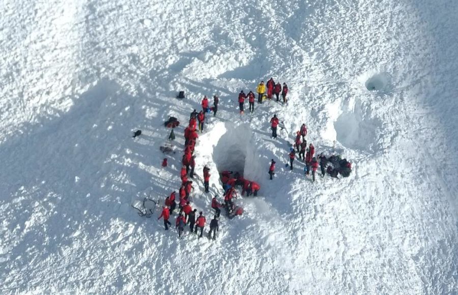 |
|
|
Snow gives way to Spring (perhaps briefly) for The Alps this week, and a bit of everything for America.
Top 100 Snowiest Ski Areas Worldwide 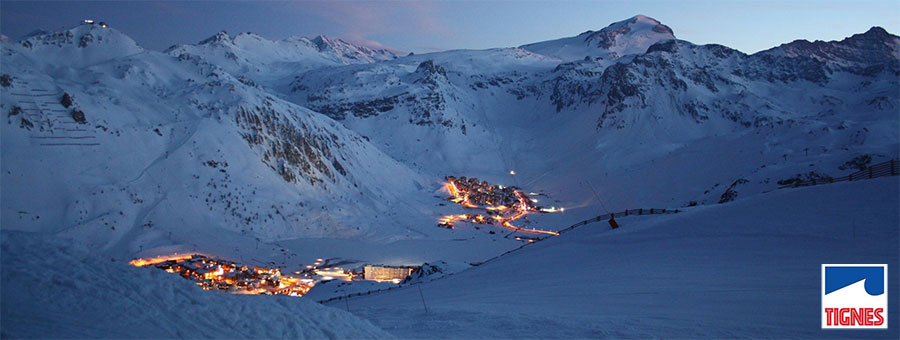
Ever wonder what the piste bashers get to see at sunset? Tignes, France this week This Week's Snow Headlines - Mammoth snows base finally falls from 889cm high to 864cm. - Dry and sunny in the Alps. - Storm Stella brings up to 1m/3.3 Feet of fresh snow to the US East Coast. - Scandinavian ski areas report up to 45cm of snow in 48 hours. After a snowy end to last week in the Eastern Alps with significant snowfall in Austria it has been mostly dry, sunny and (at lower elevations) rather warm in the Alps. That looks set to remain the weather picture up to the weekend when a fresh front is expected to bring more snow to the higher slopes. What fresh snow there has been in Europe so far this week has mostly been in Scandinavia where a number of Norwegian resorts have issued powder alarms for 20cm+ of new snow in 24 hours. The avalanche risk remains very high across the Alps and BASI and the British Mountaineering Council issued a joint warning for the Alps on Tuesday urging skiers and boarders who want to leave the pistes only to do so with a qualified guide if the guide thinks it's safe to do so. A large avalanche yesterday claimed the lives of 4 skiers in Austria. Across the Atlantic it has been a more mixed picture than usual. Rather than the usual West coast united front there have been some good snowfalls in Western Canada whilst the Western US has stayed dry. On the east, storm Stella brought up to 66cm (2 feet 2 inches) of snow to ski areas that had previously been worried it was too warm with some having closed early, now re-opening. In the Forecast Temperatures look like remaining mild in The Alps for much of the next week, albeit with some snow expected at altitude on Sunday and into Monday. This is likely to be heaviest in the East (Austria) and the rain/snow line will be relatively high so good for high slopes and not so good low down. That said, Spring could be kicked back into touch in a weeks time, by a cold and - potentially - very snowy turn of events for which the forecast models are starting to align. It's at the edge of the reliable time-frame for the forecast at the moment, but could be good, so we'll post an update to the forum early next week. In the meantime, enjoy the sunshine! Going Skiing? Please upload a Photo Snow Report! If you're in the mountains, please show us the snow! Check Snow Reports from Ski Resorts for a quick and easy way to upload pictures, straight from your phone. The Alps Austria Austria has stayed rather snowy over the past week and the end of the season (only a fortnight away at some of the smaller, lower areas) is looking much snowier than the start was. Kaprun, for example, reports all lifts and runs open, with nearly two feet (57cm) of snowfall in the past week and an 85-195cm base. St Anton has some of the most impressive stats in the country with a 60-290cm base including 50cm of fresh snowfall this week. Mayrhofen has more challenging conditions with a 0-90cm base and 15m of fresh snowfall reported, it should still be good to host the Snowbombing Festival in three weeks' time though. But most areas are looking good to make it through to the end of their seasons. France Very little snow in the French Alps this past week France and conditions are typically being described as 'springlike' which generally means it gets sticky as the day warms up and is best first thing. Thanks to the snow since Christmas most areas have decent bases so coverage is not generally a problem, even resorts like Morzine which struggled earlier in the season have a 70-100cm base. But most of the high altitude resorts have much more impressive numbers, with at least a metre lying at resort level and 2m+ up top. Bonneval currently tops the snow depth table at 3.1m. More snow should arrive at the weekend if the weather pans out as forecasters currently predict. Italy No snow in Italy for a week either and conditions are again 'Spring like' here with groomed slopes varying from hard-packed to high-quality and off piste heavy going, with the avalanche danger again high in any case. The season long divide between West and East continues with most resorts in the alps to the West boasting 1-2m bases meaning they're in good shape for the remainder of the season. There's much less snow still in the Dolomites and the 10-40cm lying in Alta Badia coupled with spring like conditions does not look good moving in to April, but then they've survived all season on snow making so this may see them through to the end of the winter. Snowfall is, in any case, expected from the weekend when conditions will become more changeable. Switzerland As with the rest of Europe there's been little or no snow in Switzerland since last Friday and for some resorts for more than a week. So on piste conditions are excellent, off piste the snow is getting old and heavy and of course the avalanche danger remains very high. On piste the quality of the snow varies through the day and by altitude with lower resorts suffering stickier conditions by the afternoon, higher slopes remaining fresh. Gstaad still claims the deepest snowbase at 4.3 metres but that's down 60cm from last week. Scotland Scotland's terrible 2016-17 season continues to be, well, pretty terrible. After hitting a seasonal high with four of the five areas managing to open limited terrain last week and around 40 of the region's 125 ski runs being open, only Nevis Range was open on Tuesday with 10 upper trails operational. However some centres were stormbound due to strong winds and may open limited runs later this week. However temperatures are remaining often above freezing so there are no signs of a change soon. Pyrenees No fresh snow really in the Pyrenees either, just a few centimetres reported at Grandvalira in Andorra. Bases are very good for the time of year though with 1-2m reported at most areas in all three countries so it's looking good for the remainder of the season, and there's more snow in the forecast here too. Scandinavia Norway has seen some of the biggest snowfalls in Europe this week with up to 45cm, reported by resorts like Bjorli and Voss, some of the bigger resorts like Hemsedal got 10-20cm too. Bases across Scandinavia look good as resorts move in to spring with 70-130cm the norm, about the usual for this area. Bigger snowfalls are expected in the coming week, further improving conditions. Eastern Europe Bansko caught 15cm/6 inches of snow last Friday but otherwise Eastern Europe, like Western Europe, has been largely dry and a little warm this past week. Most resorts still have good bases though here too to see them through the remainder of the season. Bulgarian resorts all report at least 80cm lying; in Slovenia it's a little less impressive at 30-60cm and Spindleruv Mlyn in the Czech Republic reports 40-90cm. Like Western Europe again, more snow is expected from the weekend – hopefully delivering 30-50cm of snow. Canada A snowy week across Canada, initially in the west and in the past few days with big snowfalls in Quebec related to Storm Stella. Base depths are good across the country with Mont Ste Anne still claiming the deepest in Eastern North America at 4.3m, it claimed 35cm of snow in 24 hours up to Wednesday morning but was beaten by Mont Sutton to the south with 55cm of snow. In Alberta, Sunshine has enough snow to open its 'Wild West' freeride area for the first time in three years this week, the three Banff resorts of Mt Norquay, The Lake Louise Ski Resort and Sunshine Village have each received between 60cm-101cm of fresh powder since the start of the month, with more in the forecast later this week. USA Unusually America has seen little or no snow in the West this past week but big snowfalls in the east over the last few days, thanks to Storm Stella. In fact the storm even allowed resorts in the south east that had closed early due to unseasonably warm weather to re-open with powder on Wednesday. Wisp in Maryland was one beneficiary with a foot of fresh snow but the big winners were the larger, northern resorts like Mount Snow and Killington which both reported just under 1m (3.3 feet) of fresh snow over 36 hours. Conditions in the west have been more problematic after the huge snowfalls of this winter with some seeing double digit plus temperatures this week leaving very slushy conditions at times. Bases remain huge at most though, Mammoth now on 8.6m, Squaw still over 6m/20 feet. Another front is expected to bring plenty more fresh snow to the West later this week. |
|