Messages posted by : admin
Too far out, blah blah blah... 8) However, if you look at the GFS output on Ventusky (for the 26th) you can see a very nice, clear (and not atypical) setup of an Atlantic High and a Scandinavian Low combining to bring a strong northerly flow over Europe next week. Here you go... 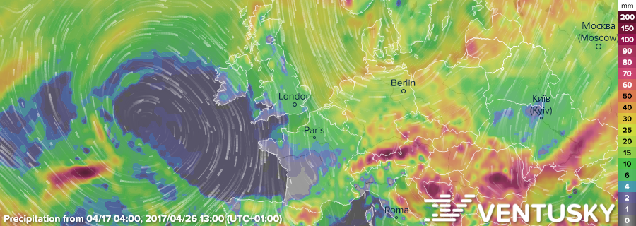
Live link so you can run the animation from today if you like... https://www.ventusky.com/?p=52.1;-0.4;4&l=rain-ac&t=20170426/12&m=gfs Zoom out a bit for best effect. That's the sort of set-up we would have liked to have in December and January, and it may not happen next week but that's the way GFS is leaning at the moment. You can see where all the cold and precipitation in the long-range forecast is coming from. |
|
Bigger budgets and brains than ours are working on that continually... I suggest you follow our advice and not rely on the long-range... I woke up this morning (no, I'm not about to sing the blues) and my best local forecast (UK, no mountain complexity involved) informed me that my day was to be overcast all day... whilst outside was blue sky from horizon to horizon. Who can I sue? |
|
|
J2Ski Snow Report - April 13th 2017
Spring skiing continuing for The Alps, with some fresh expected, and the first snows for the southern hemisphere. This is our final weekly round-up for the winter; after Easter we'll be reverting to a monthly summary until the snows come again to the North. 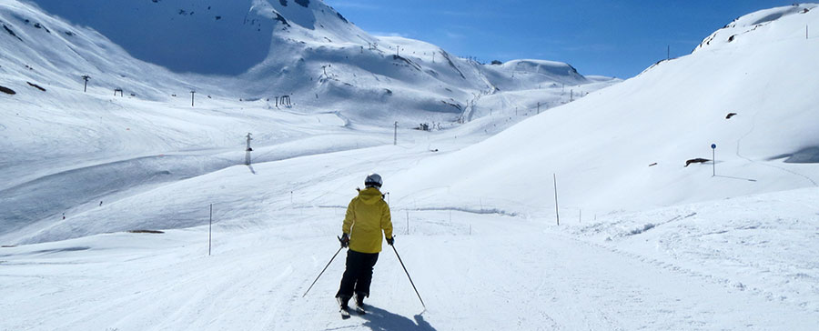
Spring skiing, Val d'Isere, France this week Top 100 Snowiest Ski Areas Worldwide This Week's Snow Headlines - 15-20cm of snow two months before the 2017 season starts in Australia and New Zealand. - Around 20% of ski areas now closed for season with more than 50% due to close after up-coming Easter Sunday weekend. - Up to 70cm of fresh snow in California, Colorado and Utah. - 10cm of fresh snow in Romania. - 50cm of fresh snow this week at Whistler. - Winter conditions in Norway, with up to 25cm of fresh snow. You know that the season is starting to wind down when more snow is reported falling in Australia and New Zealand than in the Alps! But to be fair that is exceptional for early April - unusual weather in the southern hemisphere brought 15-20cm of snow to the slopes of ski areas in Australasia last Sunday/Monday. It was short-lived, of course, and staff at the resorts were questioning if they'd ever had such sizable snowfalls in what is still early autumn there. In the Alps it has been April weather as we might expect it with warm temperatures and mostly sunny days so classic spring skiing on higher slopes with hard snow first thing, good conditions from mid-morning to early afternoon and then slush. Lower resorts have more challenging conditions with little snow left and many have closed or will close after the coming Easter weekend. There is more snow in the forecast, at altitude, and a return to cooler conditions looks likely after Easter however. Across the Atlantic there have been still more big snowfalls on the western side of the continent as there have been almost non-stop since late November last year. In the Forecast Significantly cooler weather (for April), with some heavy precipitation, is now forecast next week. The heaviest falls are expected for Austria and eastern Switzerland, and snow should be falling by Easter Sunday with quantities building through the first half of next week. To the West of the Alps (France and western Switzerland), temperatures will be higher and precipitation lower - but still enough to freshen things up from 2,000m and above. The Pyrenees *may* also get some decent Easter snow, although the forecast models at present look much less certain about that, and temperatures will likely be high enough to confine any new snow to upper slopes. As always at this time of year; do check local conditions and resort opening times directly before travelling! Going Skiing? Please upload a Photo Snow Report! If you're in the mountains, please show us the snow! Check Snow Reports from Ski Resorts for a quick and easy way to upload pictures, straight from your phone.
The Alps Austria About half of Austria's ski areas have now closed, a higher proportion (marginally) than the other leading ski nations, but it will have more ski areas open by mid-May than any other European country. There's just been a few inches of fresh snow reported on the country's higher slopes in the last few days of last week. The country's glaciers have the deepest snow at around 2m deep, elsewhere it is thawing and the bases are thinning – down to zero in many resorts at the base of the slopes. Zell am Ziller has the least snow up top with only 35cm at the top of its slopes. France Most French ski areas remain open though many will close at the end of the day on Sunday afternoon coming up. There's been little or no fresh snow; only Bonneval and neighbouring Val Cenis on the Italian border claimed 10cm of snow a week ago and the spring thaw is well underway. Many of the bigger French areas do have large parts of their ski areas open above 2000m though and the snow at this altitude is staying good through the day even when temperatures reach double figures. Of course it is getting soft by mid-afternoon but as we approach mid-April, that's just normal. Bonneval also has the deepest base in France at 50-290cm, but bases are fairly good for the time of year at most other French areas too. Val d'Isere, for example has a 60-160cm base and is looking good to operate through to May 1st. Italy About a quarter of Italy's ski resorts, mostly in the Dolomites, have now closed for the season. Cortina, which reported 30cm of fresh snow last week, will stay open through to May 1st however. Mostly though its spring melt down time across Italy with few ski areas reporting more than 30cm of snow left on lower slopes, most zero. Up top Macugnaga has the deepest remaining base at 2.4m/eight feet, and la Thuile the second deepest at 2.1m/seven feet but most Italian areas have a metre or less of snow left on upper runs and will be closing after this weekend. Switzerland Most Swiss areas are still open and there were a few inches of fresh snow across the country towards the end of last week. As is normal for this time of year there are few resorts with any snow left at the base of the runs. Of those that do, Verbier reports 10cm lying, Saas Fee 15cm. Up top though Swiss resorts continue to claim some of the deepest bases in Europe with 4.5m/15 feet at Gstaad and 3.3m (11 feet) at Andermatt. Most other Swiss resorts have 1-2m of snow up top, plenty for the last week or two of winter 2016-17. Pyrenees Ski areas in the Pyrenees are in great shape for the final weeks of the season and even reported another few inches (5cm) of snow last week. Bases in Andorra are 40-140cm in resort and 130-230cm up top. Of course its spring freeze-thaw skiing but definitely a good end to the season here. Scandinavia Unlike the rest of Europe, the majority of Scandinavian ski areas endeavour to stay open to late April and often into May as, in theory, the thaw arrives later. In fact bases here are little changed on last week (60-120cm / 2-4 feet) and in some cases (again unlike the rest of Europe) are actually deeper as there has been more fresh snow in Norway, with 25cm of fresh snow in Voss. Scotland Scottish ski areas remain closed for snowsports due to lack of snow cover. Eastern Europe The thaw is well underway in Eastern Europe and lots of ski areas have closed for the season but there has also been 20cm of fresh snow reported in Romania at Poiana Brasov at the end of last week. Bulgarian slopes are looking tired, particularly the lower runs. Pamporovo is down to a 20-40cm base. North America Canada Canadian ski areas have started closing with Silver Star and Red Mountain in BC amongst the first to call it a day on winter 16-17. But the snow is still falling and bases remain good across the country. Most resorts have at least 1.5m/5 feet on upper slopes with Whistler now posting the deepest base at nearly 3.6m (12 feet). It's open to mid-May, as is Sunshine near Banff (223cm base) and Lake Louise (160-240cm base) to the start of May. Most other Canadian ski areas will close after this weekend or next. USA A full on return to winter in Western USA with 70cm of new snow at Mammoth in California and Alyeska in Alaska – the most reported at any resorts in the world this week. Snowbird and Solitude in Utah reported more than 50cm and Breckenridge and Winter Park more than 40cm. Many resorts in the area are reporting conditions as 'powder' which is pretty good for mid-April. So some of the best conditions in the world at present are to be found in the Rockies and mountains further west, but many resorts will close this weekend despite the great conditions so you need to move fast. But plenty of US resorts do stay open in to May and beyond including Arapahoe Basin in Colorado, Snowbird in Utah and Mammoth and Squaw Valley in California. |
|
|
I think that's a reasonably fair summary of GFS vs ECM Mr Beep, although in our case we do in fact pay a 3rd party post-processor who apply their own topographical modelling to the GFS data. Snow-Forecast - I believe - apply their own topo processing to GFS although theirs, IMHO, appears to amplify some of the long-range swings.
We watch the large-scale output of both (and several other) major models on a regular basis and there's really not much to choose between them nowadays; sometimes ECM will pick up a pattern change while GFS is still swinging around wildly, and other times GFS will go first. GFS 7-day improved noticeably when they increased their resolution a few years ago. We've also seen several falls this season that ECM hasn't picked up on - I'm pretty sure that the "mini retour d'Est" that briefly hosed Valfrejus and Bardoneccia in early December was one of those (I remember that because I didn't believe the forecast at the time and dismissed it as a glitch until I was sent a picture of a buried chairlift...).
Fair point on the thunder; we've noticed that a few times too and have fed back to our suppliers.
The 8C is the daytime max, although there does seem to be a data error there as the snow line is shown only coming down to 1970m (i.e. above the town). Edited to add :- there is another update being processed now. |
|
Well, keep checking Ventusky in the meantime; that storm's a really nice illustration - if you see J2Ski's forecast swing the snow back out again, it'll be because GFS has decided the storm's going somewhere else (or fading completely). |
|
It doesn't. Check the first few locations on our "snowiest locations" list at https://www.j2ski.com/snow_forecast/. Not much snow in the forecast for much of the US at the moment is there? As for Europe, next week is looking full of precipitation and quite possibly cold for April too. Watch the GFS visualization on Ventusky; lots for The Alps and around the 18th a potential fizzer rolling a bunch into the Pyrenees... https://www.ventusky.com/ ...and that storm's a nice example; if subsequent model runs (or the eventual reality) push it slightly North then the snow now forecast for Andorra will end up being rain in Bordeaux. Ventusky is nothing to do with us; but we think it's a very cool and easy way to get the big picture of the forecast model outputs. |
|
|
Jeez guys, step away from the tin-foil hats. Your expectations of long-range forecasts are un-realistic and completely at odds with everything we ever say about them here!
If we did actually mis-represent the forecast the way you've just done (to be fair, there are sites out there that do this - but we don't), then you'd have a point. This is what's on the (Chamonix) page right now...
and
and
Nature and weather do not follow a script. Weather is chaotic. Mountain weather especially so. You've spent time in the mountains so you know that. Our forecasts are driven, as we've discussed before, by GFS and the way to view them is as the "latest best guess". They will change, often dramatically, from run to run and over the course of a ten day projection a small change in - for example - the track of a storm could shift it 300 miles compared to the previous run ("loadsasnow" -> "no snow" -> "loadsasnow" ). That's just how they work. I've tried to explain some of it before, but clearly not well enough, so it'd be worth your while spending some of your summer time looking into how the forecast models work. As we've said many, many times; a reliable long-range weather/snow forecast does not yet exist. As soon as it does, we'll have it here but don't hold your breath. The right way to use the long-range forecasts - Accept that they are dynamic and will change. - Check them frequently and regularly; so you get the latest "best guess". - Get a feel for how they're evolving... - If they're swinging wildly then one of those outcomes is likely, but the models don't know which. - If consistency builds from run to run then confidence can grow. Anyone booking a holiday solely on the basis of a long-range forecast (ours or anyone else's) would be doing so against our clear advice (in this post and thousands of other pages), not because of it. You can certainly use consistent patterns - when they occur - to inform your decision, but the weather won't follow the script... Clear enough? |
|
|
J2Ski Snow Report - April 6th 2017
Spring Snow at altitude for The Alps, and Pyrenees. 
It's Spring in Les Arcs, France Top 100 Snowiest Ski Areas Worldwide This Week's Snow Headlines - Up to 50cm of fresh snow in the French Pyrenees. - Up to 45cm of fresh snow in the Western Alps. - SkiWelt ends its 2016-17 ski season. - Zermatt issues powder alarms for 2 successive days of 20cm snowfall. - Over four feet of snow in Alaska. The 16-17 season is starting to wind down now with the first of Europe's big ski areas, Austria's SkiWelt, ending its season last weekend. A good many more will end theirs next weekend, including many in North America, although most on each side of the Atlantic will keep the lifts turning and the slopes groomed until after Easter weekend. But April is starting snowier than December did for many resorts, with centres in Europe and North America reporting up to 50cm (and a few much more) of fresh snow in the past week. For North America this seems to mean more winter and powder like conditions and in the Alps it's helping to freshen up the pistes, if not exactly convert the slopes in to a powder paradise. There's been snow reported in the Pyrenees and Western Alps over the weekend and more recently in Austria. In the Forecast A very mixed outlook for The Alps at present, with warm weather continuing in the west and cooler weather bringing a little more snow to the east. Alpine regions (east and west) should revert toward seasonal averages next week, with unsettled weather from mid-week bringing more top-ups of snow to the higher slopes. There is still good Spring skiing to be had at altitude but, as always at this time of year, do check conditions and resort opening times before travelling! Going Skiing? Please upload a Photo Snow Report! If you're in the mountains, please show us the snow! Check Snow Reports from Ski Resorts for a quick and easy way to upload pictures, straight from your phone.
The Alps Austria Not much snow in Austria over the past week but the good news is that the one resort that reported a big snowfall, last Sunday, was Ischgl claiming 25cm, and it's one of the few Austrian areas due to stay open to the start of May. Otherwise more will begin closing this weekend and most after Easter. So far the biggest area to close is one of Austria's three largest, the Skiwelt which becomes Europe's first big ski region to close for the 16-17 season. Of the still-open Austrian areas things are looking best on the glaciers where most centres have at least 2m of snow, although St Anton (no glacier) still has a 2.5m base up top and 50cm in resort. It's the exception as most non-glacier Austrian areas have less than a metre now on their upper slopes and nothing, or just 10-30cm, on lower runs, although that's normal for the time of year of course. France It has been a fairly snowy week in France with the higher resorts in the Alps and ski areas down in the French Pyrenees reporting 20-30cm of new snow. Cauterets in the Pyrenees even reported 50cm of fresh snow, the most in Europe this week. Tignes and Val d'Isere reported the biggest falls in the French Alps on Sunday and Monday with around 20cm of fresh snow, but there was 5-20cm of snow at many other resorts, particularly above 1800m, with Chamonix's higher slopes and Val Thorens among the beneficiaries. Montgenevre, which has a 140-250cm base and 15cm of fresh snow is one of the best for snow cover in France. More moderate snowfalls are expected in the week ahead and bases look good enough across the country in any case for the remainder of the season. Italy Western Italian ski areas reported 15-35cm of fresh snow on Sunday, boosting the bases ahead of the final weeks of the winter season. Cervinia claimed the biggest snowfall. It has a 30-200cm base, one of the best in the country, although Macugnaga, which got 25cm of fresh snow, has a slightly better 40-240cm. the latter stat the deepest base in Italy at present. No real respite in the Dolomites though, with no fresh snow reported and bases still very thin around the 10-40cm mark at best and it is naturally enough 'spring ski conditions' across the country in any case. Switzerland Switzerland reported a similar week to France with just a few resorts doing very well for fresh snow (Grindelwald 30cm, Zermatt 40cm, Saas Fee 50cm), but other resorts having a less snowy week with a handful more reporting just a few inches. Very few Swiss resorts now have any snow left at village level (Arosa, Saas Fee, Verbier and Grimentz report 20-30cm) but on the mountain most areas still report 1-2m, plenty, probably, to see them through the final few week of the season. Andermatt with 350cm and Gstaad with 480cm are the deepest reported bases in Europe for the main ski resorts at present. Scotland All five Scottish ski centres are closed due to a lack of snow. Pyrenees The Pyrenees have had one of the best seasons of all the mountain regions in Europe and it is rounding off 2016-17 on a high with more snow, particularly on the French side where up to 50cm of new snow has fallen since the weekend. In Andorra bases are up around the 1.5 – 2.5m mark on upper run which means things look very good for the Easter holidays and the final weeks of the season. Scandinavia Little change in Scandinavian ski conditions this week with still a month of the season left at many resorts. Just a few centimetres of fresh snow (Norway's Trysil reported the biggest fall – some 13cm) and bases typically in the 70-90cm, mark on the mountain, pretty normal stuff for Finland, Norway and Sweden. Eastern Europe Cover is getting thinner in Eastern Europe and some ski areas have begun to close for winter 16-17. At Spindleruv Mlyn and Jasna in the Czech and Slovak Republics there's only 20—30cm on the slopes. Apart from Pamporovo (50cm up top) most of the Bulgarian centres still have over 1m on upper runs but down in resort the base is thinning fast at Bansko, down to 20cm. North America Canada It has been another snowy week in Western Canada with up to two feet of snow (58cm at Big White) reported falling and most area getting 15-40cm. Whistler with a 338cm (over 11 foot) base and 35cm of fresh snow this week has the deepest reported base still but most Canadian resorts still have at last 2m of snow lying on upper slopes and several others (Fernie, Revelstoke, Big White) around 3m. There's not been much fresh snow reported in the East but bases remain around the 1m mark in Quebec which should be enough for the remainder of the season. Similar snowfalls expected in the coming week. USA There's been a late dump of snow in Alaska this week with Alyeska resort reporting the biggest snowfall in the world over the last seven days with more than four feet 126cm) of snow dumping down. Elsewhere on the West side of the USA there have been 30-45cm accumulations in many resorts from Taos in New Mexico and Breckenridge in Colorado over to Alta in Utah and Jackson Hole in Wyoming. So the final weeks of the season are continuing to see the snow falling as it has been since late November here. Conditions are described as 'fresh' powder' and 'excellent' in contrast to Europe's 'spring snow' There's been snow on the East Coast this week too with Killington in Vermont reporting the biggest snowfall here with 30cm. Both East and Western side of the US are expecting more big snowfalls over the next few days. |
|