Messages posted by : admin
|
Fur lined boots this year then Dave?
You might need a second puppy if you want to do both pairs though... |
|
|
J2Ski Snow Report - November 6th 2014
Snow Report Summary 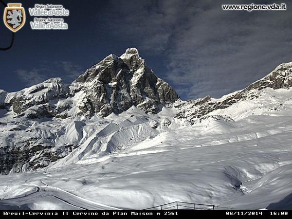
Picture courtesy Cervinia This Week's Headlines - Verbier to open early, this weekend. - Heavy snow in New Zealand ahead of season's final weekend. - Ski areas open from East to west Coast USA - Canada's ski season due to start today. - First significant snowfall in the Pyrenees. - Levi get FIS OK to stage next World Cup races. Considering it is just the start of November, this has been an exceptional week for snow in the Alps, but also in other areas around the world. The Alps are seeing their second major snowstorm in two weeks, with reports of 2-3 metre accumulations possible already. This snowfall is ongoing so we're attempting to report on a 'fluid situation' but so far accumulations of up to 1.5m (including Obergurgl) have been confirmed and snow is expected to continue into next week. Verbier is the first major resort to announce it will be opening early, this weekend (3 weeks ahead of schedule), because of all the snow. The snow is reported to have fallen as torrential rain at lower altitudes and there have also been gale force winds in places (some forecasts expected hurricane force 12 winds!) but so far there are no reports of major structural issues at resorts. Elsewhere in the world there have been the first significant accumulations in Scotland and the Pyrenees and in the USA cold weather and some natural snowfall has led to resorts opening across the country from Colorado to North Carolina. It is supposed to be the last weekend of the 2014 in the southern hemisphere coming up with only Turoa open but there's been unprecedented late snowfall across the country there too so it's not clear whether there may be an extension. In the forecast The models are indicating more snow, after a brief pause over the weekend, through most of the next couple of weeks. At present, the North and West of The Alps look like getting the lion's share, but with the forecast changing (and changeable) the snow is likely to be widespread. We would caution that temperatures are slightly on the mild side for November so low levels may be wet, but mid to high level ski areas are going to be accumulating good bases by the end of the month. The Alps Austria With its eight glacier areas all open, Austria is perhaps the best placed resort to take advantage of all the recent snowfall in the Alps. Conditions were already excellent on the glaciers during sunny weather after the last snowfalls a fortnight ago, now they look set to be better still. The snow is still falling heavily but many areas are reporting 30-60cm of new snow so far including the Pitztal (45cm, in 24 hours), Kaunertal, Dachstein, Stubai and Solden glaciers. Snow depths have hit 1.5m on the Kitzsteinhorn and 2m on the Mollal glaciers. Solden says it plans to open its full area the weekend after next thanks to all the snow,. And non-glacier resorts Obergurgl and Obertrauern are due to start opening then too. It is not yet clear if resorts that sometimes open some of their terrain in early November, if conditionals are good, including Kitzbuhel and Schladming, have plans to do so this autumn. France France is currently the least best placed of the big four Alpine resorts to capitalise on all the fresh snow. Facebook is showing amazing images of many French resorts, particularly Avoriaz and Chamonix, but for most the official opening date remains 4-6 weeks away. It is unclear if any will wish or be able to open early. However Tignes is still open, although it had to close fort the past few days due to strong winds accompanying the heavy snow showers. Italy Some of the heaviest snow of the past few days has been reported in Italy with the Presena Glacier posting that it had received 70cm in 24 hours. It's not open yet but three glaciers at Cervinia, Val Senales and Passo Stelvio are. Val Senales says its base is now at 2m after 80cm of fresh snow in recent days. Cervinia has had over a foot of snow and has a 1.2m base. Switzerland Swiss resorts too are looking good. Saas Fee, which has been open since July, has announced runs will be extended off the glacier and down the mountain from this Saturday thanks to all the snow. Zermatt, open year round, said it had had 30cm of fresh snow in the first 24 hours of the snowstorm. Also open is Glacier 3000 above Les Diablerets and Gstaad and the Diavolezza glacier near St Moritz but the formerly open Titlis glacier at Engelberg is in the midst of a 10 day scheduled maintenance shut down until next Friday the 14th. Verbier has announced it will open three weeks early for the season on Saturday. Scandinavia Ruka and Levi in Finland remain the two centres open in Scandinavia. Both have just a handful of runs open and snow depths of 20-50cm, largely thanks to snowmaking although there has been natural snow too. Levi recently passed FIS course inspections ready to stage World cup racing the weekend after this. Pyrenees It's not just the Alps that are looking snowy – resorts across the Pyrenees have been posting snowy images over the last few days, with one of the largest, Baqueira Beret in Spain, reporting 20cm of fresh cover. North America Canada Canada's ski season was due to kick off last weekend at Norquay (Banff) for Halloween but snow conditions weren't quite right. This weekend is looking better and Naskiska is also due to open but Lake Louise has beaten them to it, opening today (November 6th). There's little info on snow today but it looks good in the pictures! USA Snow from California to North Carolina in the last week, along with low temperatures for snowmaking means that the number of ski areas open this weekend in the Us will be in double figures, making it the first country in the world to be able to claim that. Loveland joined Arapahoe Basin as the second area open in Colorado and they're due to be joined by Keystone and Copper mountain, both a week later than planned, this weekend. Also in the West, Timberline in Oregon is also open. Areas in the Midwest that opened last weekend thanks to snowmaking include Wild mountain in Minnesota, while Sunday River in mine and Killington in Vermont are also open on the East. However the deepest snow in the US right now, at around 70cm, is reported to be in North Carolinas where surprise early snowfall led to the opening of Sugar Mountain Resort and Cataloochee Ski Area Southern Hemisphere It's supposed to be the last weekend of the 2014 ski season coming up in the southern hemisphere with the last resort still open, Turoa on New Zealand's Mt Ruapehu, supposed to be closing for the season on Sunday. However there's been heavy snowfall and the base level has jumped back up from 1.5m (to which it had dropped from 2m a week before that) to over 1.7m, so it's not yet known if there'll be a change of heart and a further season extension. |
|
What's that coming, over the hill... BIG Snow Incoming
Started by User in Snow Forecasts and Snow Reports, 12 Replies |
|
:lol: :lol: Not at all... forecasting snow is a mug's game with current technology but the short-term forecasts are generally better than they were a few years ago, and improving. We just need to manage expectations is all... ...but it has most certainly snowed today, and that's what counts. 8) |
|
What's that coming, over the hill... BIG Snow Incoming
Started by User in Snow Forecasts and Snow Reports, 12 Replies |
|
I shall ban you at once... :lol: Our forecasts most certainly are NOT always right... though do bear in mind if you're watching it rain then it's snowing further up. 8) The perennial issue with big snows is that they tend to be localized (often along the boundaries between, e.g. a moist, mild weather system and a cold, dry one)... so if the system shifts just a little then all the snow will fall in one valley and not another. So far, it's looking like this snow event is more widespread and lower than forecast - we didn't think it'd go lower than 1500m (snow-forecast had the snowline well above that) but it's currently starting to settle around Morzine... and it's most certainly snowing heavily in the Aosta Valley, as forecast. |
|
|
They stick around until you delete them. Did the "Private Messages" text on the blue bar not show up Red (to show you had un-read messages)?
|
|
Ok, so how about adapting your style - just a little - to suit more modern kit? Book yourself in with a decent ski school / instructor and give them a chance to bring you on. You'd almost certainly find, with the right instruction, that you only need a couple of hours of directed practice to start having fun (and working less hard) on current skis. You don't have to go "full shovel" on the tips as there are a bunch of all mountain skis that are shaped, but not to extremes. Then your problem won't be lack of choice in new kit... 8) There are a few of us on here of similar "vintage" to yourself, who started out on "straight" skis but wouldn't go back. |
|
What's that coming, over the hill... BIG Snow Incoming
Started by User in Snow Forecasts and Snow Reports, 12 Replies |
|
"Only" about half a metre over the next 24 hours Tony... 8) Swiss Meteo have issued severe weather and avalanche warnings for the area a little further South (Saas Fee, we're looking at you) and it looks to be absolutely chucking it down there and in the Aosta Valley overnight tonight and into tomorrow. Seriously, getting on for 2 metres of snow over the next 48 hours in places.
We'll see, but from the forecast at the moment the snowline looks to be below 1700m by the end of tomorrow and lower by Thursday morning in many places. Much will melt, of course, but there's a lot coming down! |
|
What's that coming, over the hill... BIG Snow Incoming
Started by User in Snow Forecasts and Snow Reports, 12 Replies |
|
|
For the past 7-10 days, pretty much all the forecast models have been indicating some significant Alpine precipitation this week.
The leading edge is now within the 48 hour window and Tuesday and Wednesday look like seeing some very substantial snowfall in places. Although still on the mild side beforehand, temperatures will drop significantly as the snow falls and it's likely to be below 1500 metres over a wide area. The main event looks like it'll be to the South of the main Alpine ridge, with the Aosta Valley, Dolomites and Southern Alps firmly in the firing line, but there's a possibility of some big snowfalls coming in to the Northern French Alps and central/South Switzerland as well. For a bit of fun, check our French, Italian and Swiss snow pages and sort the main table by the "48 hour" column (amount of snow expected in the next 48 hours)... French Snow Forecast - Isola and Auron could see over 1 metre in the next 48 hours. Snow Forecast for Italy - Alagna and Champoluc are looking at anything up to 2 metres of snow by Thursday. Swiss Snow - Saas Fee and Zermatt sitting pretty. Obviously, all usual caveats apply - it may not happen quite as forecast, and it all might melt before Xmas but it's going to be fun to watch. We'll be digging out (ho ho) some prime webcams to keep an eye on later... enjoy the snow, er, show. |
|