
Flaine, France: fresh snow and open until 19th April
Alps back into full winter as April begins, with many resorts recording well over 1 m/3 ft of new snow and significant avalanche risk across central and western zones. Elsewhere, Scandinavia, Scotland, Eastern Europe and the Pyrenees saw fresh snow, Canada got regular top-ups, while many western US resorts closed early amid warm conditions.
The Snow Headlines - April 2nd
- Chamonix Posts over 1 m/3 ft Of Snowfall in 72 Hours On high Terrain.
- Meltdown in Western US as big name resorts, including Park City, close early.
- Austria enjoys snowiest week of 25-26 ski season to end March.
- Scotland's Cairngorm nears five months of non-stop lift-served winter sports.
- Bulgaria sees late season boost with nearly 30 cm/12 inch of fresh snow on higher terrain.
- 7 Day snowfall totals of up to 1.5 m/5 ft in Alps.
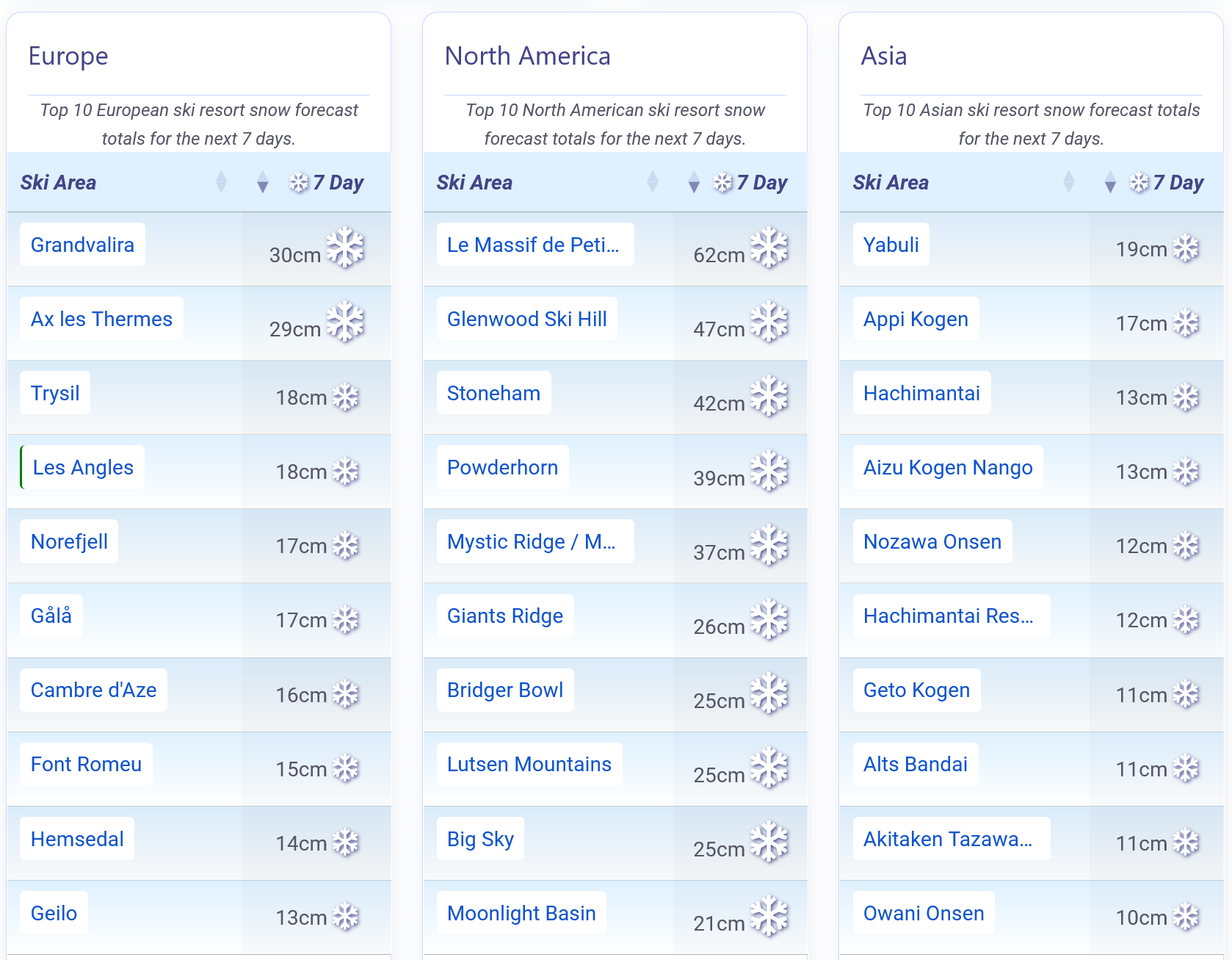
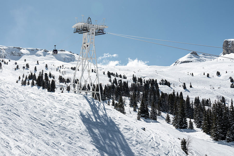
Snow forecast for the Alps, America and Japan.
Re-publication :- the J2Ski Snow Report Summary, being the text above this line, is free to re-publish, but must be clearly credited to www.J2ski.com with text including "J2Ski Snow Report" linked to this page - thank you.
World Overview
After it seemed that springtime had set in for good, the Alps flipped dramatically back into full winter as April began, with many resorts logging well over a metre of new snow in the past week. A surge of cold northern air, backed by strong winds and a sharp temperature plunge, pushed snowfall right down to the valleys and re-whitened central, northern and western slopes.
Some of the heaviest falls arrived soon after last week's update, leaving several areas digging out from 1 m+/3 ft+ by Saturday - and intermittent snow has continued since. The rapid shift has driven avalanche danger sharply higher, with large parts of the central and western Alps moving to Level 4 or even 5.
Scandinavia, Scotland, Eastern Europe and the Pyrenees have also seen fresh snow, in smaller amounts.
Across the Atlantic, the contrast remains stark. A string of early closures has swept through major US western resorts as temperatures soared far above freezing, stripping terrain and forcing operations to wind down despite a recent return to colder weather and light snowfall. Canada, by comparison, continues to enjoy regular top-ups, and the US Northeast and Quebec have also held onto colder spells and new snow.
In Japan, the season is steadily contracting as spring takes hold and temperatures rise. More areas have now shut lower slopes or closed completely, joining a growing list operating only on upper terrain. Snowfall has been modest nationwide, often mixed with sleet or rain at lower levels, and daytime temperatures continue to climb into double digits in the valleys. Hokkaido remains the cooler, snowier exception.
Europe
Austria
Austria has just enjoyed one of the snowiest weeks of the entire season, probably the snowiest, with a quick return to winter after several mild, sunny weeks. Lech led early totals, picking up 45 cm/18 inch in the first 24 hours which grew to 95 cm/37 inch in 48 hours. Snowfall reached valley level across much of the country while glaciers saw over 60 cm/24 inch. Higher slopes accumulated up to 1.2 m/4 ft over seven days, with snowfall returning after the weekend.
The coming days should turn brighter but stay cold, with low freezing levels, firm morning pistes and what should be excellent upper-mountain conditions for April.
France
This time last week we reported that the French Alps had snapped back into winter as Arctic air swept south, dropping temperatures by around 10 °C/18 °F and delivering widespread snowfall. Skiers in the Alps reported powder conditions going into the weekend.
Crucially, the cold was strong enough to push snow right down to valley level, with higher slopes collecting up to about a metre of snowfall, with Chamonix reporting 107 cm/42 inch over 72 hours on its higher terrain. After a calmer weekend, alternating sunshine and snow showers returned this week, keeping things fresh. La Plagne posted another 73 cm/29 inch by Wednesday.
Into the weekend, expect mostly bright spells, bitter summit temperatures and early signs of Easter snowfall across Savoie and Haute-Savoie.
Italy
Italian ski regions picked up fresh snow this week, with the most consistent totals in the north and west, although amounts were generally lower than further north in the Alps. The standout snowfall came further south in the Apennines where Campo Imperatore and Abetone posted up to 50 cm/20 inch accumulations.
Northern areas stayed more changeable, with Sestriere and the Via Lattea among the stronger performers; most high-altitude slopes saw 40 cm/16 inch over three days at the weekend. Madesimo posted 25 cm/10 inch at the start of this week.
A cold, settled pattern now dominates most of the country's ski regions, keeping major Alpine and Dolomite summits well below freezing.
Switzerland
The Swiss Alps have enjoyed a notably snowy spell, with last week's storm bringing up to a metre of snowfall to high terrain and snow down to valley level again before the weekend; a second system arriving on Monday brought more significant accumulations. Engelberg and Adelboden were early winners, each collecting around 50 cm/20 inch on upper slopes in the first 24 hours. By Saturday, Frutigen topped the 72-hour chart with 108 cm/43 inch of fresh snowfall reported.
Most regions then saw calmer weather before the next front arrived. Again Engelberg was a big winner, posting around 1.5 m/5 ft over the last seven days up high. Most areas have seen drier weather but still cold temperatures return over the past few days, and that's the pattern going into the weekend for most.
The week now ends cold and dry at altitude, with Zermatt, Saas-Fee, Aletsch Arena and St. Moritz frequently dipping to –10 °C/14 °F.
Scandinavia
Scandinavia has seen another round of light to moderate snowfall, with Norway's coastal areas, including Voss and Myrkdalen, leading totals. Southern and western zones have mixed in gales, sleet and rain, but most major resorts remain 95–100% open and plan to operate into early May. Overall it's looking good for April skiing with summit temperatures staying well below freezing, typically –6 °C to –13 °C/21 °F to 9 °F, colder still in Lapland.
Bright spells, light winds and occasional snow showers are expected at higher Norwegian resorts, while lower southern slopes may see sleet.
Pyrenees
The ski season in the Pyrenees ended March on a wintry note. Sunshine has been frequent, but temperatures stayed below seasonal norms, often between –9 °C and +5 °C/16 °F and 41 °F. Light to moderate snow fell through the week, typically 2–5 cm/1–2 inch, with isolated 20 cm/8 inch bursts. Grandvalira logged a notable 36 cm/14 inch on Sunday.
Most resorts are in or near their final weeks for 25-26, yet upper-mountain bases remain exceptional after a snowy winter, many still at or above 3 m/10 ft.
The outlook is mainly bright and cool, with firm spring snow and summit temperatures of –4 °C to –7 °C/25 °F to 19 °F across Andorra, France and northern Spain.
Scotland
The unsettled weather that has dominated Scottish skiing over the past month has continued into April with almost endless gales continuing to shut down lifts at the two still operating areas, Cairngorm and Glencoe. On the upside, it has kept snowing on higher terrain and Cairngorm notes it has now been operating lift-served skiing for almost five months non-stop when not closed by bad weather. It still has terrain open suited to all; Glencoe is mostly upper mountain suited to intermediates and above.
The coming week appears to be more of the same. The Lecht and Glenshee currently do not appear to be planning to use their all-weather snowmaking machines to open for Easter this year, unlike previous years.
Eastern Europe
Winter has briefly returned to Eastern Europe, with heavy snow reaching as far south as Greece and Bulgaria. Most lower-lying areas have already closed for the season, but the larger, higher well-known resorts continue for another week or two. Bulgaria's Bansko and Borovets each logged 27 cm/11 inch of weekend snowfall, with upper-mountain temperatures around –8 °C to –10 °C/18 °F to 14 °F and bases edging above freezing.
Most ski areas in the region are now seeing brighter weather with diminishing spring snowpack and freeze–thaw cycles on higher terrain.
North America
Canada
A mix of spring sunshine and timely top-ups is shaping ski conditions across Alberta and BC. Banff-area resorts remain almost fully open, with Sunshine and Lake Louise reporting over 95% of terrain available and bases sitting between 100–260 cm/39–102 inch with up to 70 cm/28 inch of fresh snowfall over the past week. In BC, the latest 48-hour snowfall totals to start the week included Manning Park (36 cm/14 inch) and Whistler (23 cm/9 inch), while interior favourites like Big White and Panorama picked up 14–21 cm/6–8 inch.
Although many areas will close over the next few weekends, overall coverage remains excellent, with most major resorts operating at or near full capacity.
USA
A colder, snowier pattern is finally returning to the US West, with fresh snowfall ending the long mild spell that saw record highs once again, well into the 20s up to Tuesday. The snow comes too late for many Rockies and West Coast ski areas which already closed early, including Mountain High, Homewood, Sierra-at-Tahoe and others, with Palisades Tahoe also unlikely to reach May. Oregon and Washington have seen widespread closures too.
The same story in the Rockies saw the biggest shock when Park City and Deer Valley closed suddenly in March.
The East Coast remained wintry, with up to 30 cm/12 inch of new snow this week, although temperatures have warmed over the past few days.