The pause continues in Europe, while the snow keeps coming for America now.
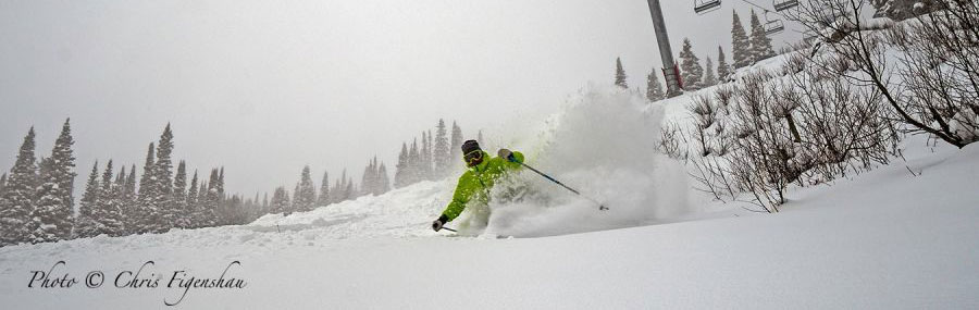
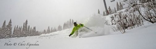
Jackson Hole this week, with over 1 metre of fresh
This Week's Snow Headlines
- Second week with no fresh snow in the Alps, Dolomites and Pyrenees.
- Second week of huge snowfalls in Western North America, Jackson Hole gets 1.5m in 9 days.
- Second major thaw in 10 days in Scotland removes most early season snow cover.
- Still snowing in Scandinavia though, 30cm for Are.
It has been another week with little or no fresh snow in the Alps, so resorts are starting to get a little nervous as 'busy times' draw nearer.
Yet still things are looking better than they have the past three years. The "most snow this century in November" (probably) is, mostly, still there as it has remained (mostly) cold. This means the huge snow making arsenal that now exists in the Alps has been able to belt out more snow onto the pistes. The result is that slopes look a bit brown and green at their edges down at resort level, but mountain tops are all white.
A change is in the air with signs of at least some fresh snow in the week ahead, albeit fairly light and mostly on the Eastern side of the Alps.
Across the Atlantic, where resorts endured "the warmest November ever" in places, the reverse is true with huge snowfalls in the West, and healthy-enough snowfalls in the East.
Other areas - the Dolomites and Pyrenees - are open but could do with fresh snow. Scandinavia, which had snowfall last week when the Alps didn't, hasn't had much fresh and two big thaws in 10 days means Scottish slopes are looking sadly green and brown but resorts in Eastern Europe are still in pretty good shape after big snowfalls last week.
Further afield, snowfall has been reported in Georgia and Hawaii (!) and Japan is getting up towards its normal deep powder base.
In the Forecast
The European Alps are currently under a high pressure system, with clear and sunny conditions.
The next few days will be quite mild, but temperatures will drop sharply as the weekend ends and next week will be considerably colder - so snow making will be in full swing just about everywhere, with the possibility of a few snow showers to help.
The breakup of such weather systems is very difficult to predict, but the forecast models are indicating some light snows (to the East) early next week and are teasing us with hints of a bigger change in the weather about a week later. That's way beyond the reliable timeframe of the forecasts but the hints are getting stronger and we keep our fingers crossed!
Find a Ski Buddy or Group
You can now easily share your plans, and find others going to the same ski area. See Recent Ski Chat and follow the Who's Skiing Where, When link.
Going Skiiing? Please send us a Photo Snow Report!
If you're in the mountains, please show us your snow! Check Snow Reports from Ski Resorts for a quick and easy way to send us pictures, straight from your phone.
Early Season Caveats Apply :- Official snow reports are still sporadic as many resorts are not yet up-to-speed and not all are reliably reporting snow depths.
Re-publication :- our Snow Report Summary, being the text above this line, is free to re-publish, but must be clearly credited to www.J2ski.com with text including "J2Ski Snow Report" linked to this page - thank you.
The Alps
Austria
More than three quarters of Austrian ski areas are now open, the majority with piste bases of 30-50cm, so not brilliant but enough, and lovely conditions with low temperatures and sunny skies so long as you're not looking for off piste powder of which there's none. It's been another week with almost no snow but there has been a few inches at a few ski areas such as Bad Gastein and a return to snowier conditions is expected in the week ahead. So far the Arlberg region is expected to get the most snow, but most areas should get at least 10cm. The deepest snow in the country is still on the glaciers with Solden and Pitztal posting the biggest bases at around 1.3m.
France
There's been no snow in the French Alps for a fortnight and there's none in the immediate forecast. On piste conditions remain good however with low temperatures and sunny days. In fact only about a quarter of leading French resorts have opened so far, although this coming weekend is the big opening weekend across the country. Montgenevre on the Italian border has the most impressive snow cover in the country – and indeed one of the best anywhere with 70cm on lower slopes and 180cm up top – one of the deepest bases in the world at present. The Chamonix Valley has 150cm still – the same as a week ago, with 30cm lying at resort level in Argentiere.
Italy
Italy too has not had much fresh snow for nearly a fortnight and not a lot is expected in the coming week, but base depths from those big November snowfalls, particularly high up, are impressive. There's 2.2m lying above Alagna in Monterosa, one of the biggest depths in the world at present and one of the few above 2m. There's a big difference from West to East though with the Dolomites having less impressive 10-30cm bases at resorts like Alta Badia and Val Gardena with no snow reported at resort level.
Switzerland
It's the same story in Switzerland with no fresh snow and almost nothing forecast for the week ahead (an inch at Samnaun on the far Eastern border with Austria). Almost all of the country's ski areas are now open and again there's a variety of base depths from 135cm at Saas Fee and 115cm at Andermatt to down near 10cm at Lenzerheide. Very few resorts have snow at resort level, although there is 20cm lying in the valley at resorts like Arosa. Verbier has 10 to 80cm of cover.
Pyrenees
Almost all of the ski areas in the Pyrenees are now open with several major holiday weekends in the region to cater for in early December. There's been no fresh snow here for a few weeks and none forecast for the week ahead but on-piste conditions are largely good with bases typically in the 30-60cm bracket. The deepest reported snow is at Formigal in Spain and the deepest snow in the wider region is at Sierra Nevada down in the south of Spain which reports a 1m base on upper slopes.
Eastern Europe
Eastern European ski areas received some significant snowfalls last week with some areas reporting as much as 60cm (Two feet) of fresh snow. Few areas have opened so far, apart from at weekends, but they are looking good compared to many resorts in the Alps with a thick layer of snow cover down at resort level in resorts like Bansko. Another 10-15cm of snow is expected in the area over the week ahead.
Scandinavia
Mixed reports from across Scandinavia this past week with little fresh snow (5cm at Hemsedal) in Norway but 30cm at the region's biggest ski area, Are in Sweden. Ruka and Yllas up in Lapland in Finland also each got around 10cm of new snow. Bases are mostly in the 30-60cm bracket across the region which is good for this early in the season and adequate to cover most of the region's slopes.
Scotland
It's an all too familiar 'British weather' story in Scotland with the five Highland ski areas enjoying a deep freeze for weeks at a time thanks to high pressure from the north, but not getting any real precipitation during that time to build bases - to then suffer double temperatures thawing away most of what cover had survived. A return to colder weather, this time with snow, is now needed.
North America
Canada
Almost all of Canada's ski areas are now open and the few that aren't are expected to do so this weekend. Whistler reports the deepest base in the country at 1.6m and says early season conditions are so good it's starting Heliski operations three weeks earlier than usual. The snowfall has slowed though after the massive 2m in a week up to a week ago with just 5cm reported since, but the snow is expected to return in the week ahead with another 60cm forecast. A lot of snow is also expected in the East in Quebec where they are also saying early season conditions are some of the best in years with around a 60cm base already at resorts like Mont Ste Anne and Tremblant.
USA
As with Canada to the north there have been some very big snowfalls on both the West and East sides of the US, and even bigger accumulations (perhaps more than two metres of snow in Oregon and Washington State in the Northwest) are forecast for the week ahead. Resorts in New Hampshire and Vermont clocked up 30-40cm of fresh snow at the weekend giving great powder conditions. There were also falls of 20-30cm in Colorado, where the snow is needed, but again it was further north where 40cm or more fell on the slopes of Montana and Wyoming up to Jackson Hole's huge five-feet (1.5m) in nine days.