Messages posted by : admin
Sorry about that... :lol: This is the aforementioned interest around the middle of the month showing up, with some wild swings in the forecast from run to run as the models try to make sense of a very mixed scenario. It looks good at this stage; with a variety of likely snow-bearing systems battling to make their way into The Alps. Will be very tough to call until much nearer the time but does have the potential for some big falls... It is much too far out to be certain (of anything) but it's a lot more encouraging than seeing high pressure systems dominating out into the long-range (as we were in December). I'd definitely bet on there being some snow, somewhere at some time - you heard it here first folks! |
|
|
Snow's back in The Alps this week, with lots coming this weekend...
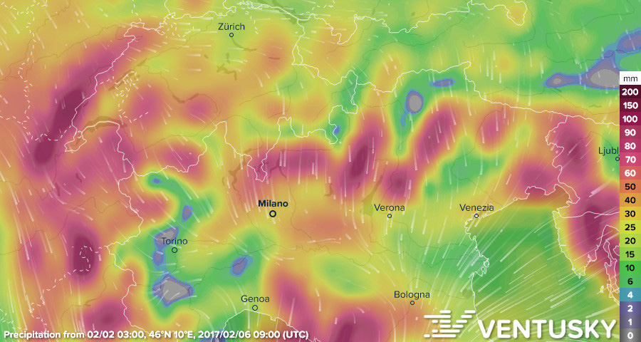
Thanks to Ventusky for this map of total precipitation over 4 days from 2nd February, Central Alps. Visit their site for glorious animations of the incoming weather systems! This Week's Snow Headlines - Snow falling in the alps again, up to 40cm in 24 hours reported. - With 7.6m base, Mammoth announces opening on July 4th, 2017 - Some snow for the Dolomites. - Californian resorts end snowiest month in history with more snow forecast. - Scottish ski areas still unable to properly start 16-17 due to no snow. - Pyrenees remain snowy with more forecast. Conditions are looking decidedly less settled in The Alps this week compared to the latter half of January and that's good news, with the arrival of fresh snow after a two week hiatus. Temperatures have warmed from -20C in mid-January to half that a week ago and now nearer freezing. The last 48 hours have seen snow starting to arrive, with an initially high snow line and rain below, although it is cooling and expected to keep falling through the weekend. It's been a drier week across the Atlantic after the two month deluge, not that it stopped snowing altogether. That's about to change from the weekend though with another big snow storm about to hit North America's West Coast. But it's the European forecast that's got our attention... snow is coming. If you're traveling this weekend We do expect some of the main snowfall to be from late tomorrow (Friday), overnight into Saturday for the Northern French Alps and Western Alps generally. A lot depends on how fast the freezing level comes down (as it's expected to, from likely rain at first) but this is likely to bring snow to low levels on what is the first big transfer day of half-term. So be prepared for travel disruption throughout the weekend, make sure you're properly equipped for winter driving and try to plan your routes to avoid the peak times! In the Forecast A succession of weather systems look set to bring precipitation into The Alps both from West and South over the next few days. Locally, accumulations may reach 40-60cm over the weekend in the Northern French Alps and Western Switzerland, and similar to the South Alps and Pyrenees. Elsewhere it looks likely to be more in the 5-10cm a day bracket, although it is going to be widespread and - with occasional strong winds - there may be substantial falls in places. More snow is also expected in the Pyrenees where it hasn't really stopped falling for most of the past month. Looking further ahead, the forecast models are throwing up some very interesting possibilities mid-month that we'll have more on next week... Going Skiing? Please upload a Photo Snow Report! If you're in the mountains, please show us the snow! Check Snow Reports from Ski Resorts for a quick and easy way to upload pictures, straight from your phone.
The Alps Austria There's been up to 40-cm of fresh snow reported in Austria over the past few days with resorts in the north of the country doing particularly well. St Anton, Silvretta, Lech and Pitztal all reported 20-30cm of fresh snow in 24 hours on Tuesday/Wednesday this week. The snowfall is expected to continue through the weekend and could greatly improve conditions in many areas although unfortunately the resort suffering the most with the least cover, Bad Kleinkirchheim down in the south East (10-20cm base) is only forecast to get a few inches more. But generally most Austrian ski areas have decent bases, have had 10-20cm of fresh snow in the past few days and look set to see more over the week ahead. France Things have been looking snowier the past 36 hours or so in the French alps. Snow was first reported falling on Monday evening and it now looks likely that many French areas will see up to a foot (30cm) of fresh cover by the weekend, which should improve conditions dramatically. Snow fall in most of the alps is not expected to be massive on any one day at present, but in most areas there'll be 5-10cm of fresh snow every day if forecasts are correct. Indeed many areas reported that much accumulating in the 24 hours to Tuesday afternoon, with Argentiere reporting the most with 13cm. The further away they are the less certainty there is of forecast accuracy, but currently it seems this pattern could continue well into next week. Bases remain good across much of the country with many areas having 1m+ on lower slopes and 2m+ on upper runs, but some do look like they need fresh cover again pretty badly including traditional resorts in the Portes du Soleil (10-20cm at Morzine and 20-60cm at Chatel). Italy Snow is starting to fall in the Dolomites at last after a very dry autumn and winter to date. Many areas are expected to get up to 50cm of fresh snow over the coming week with 5-15cm accumulations expected daily. This should really transforms things from the current white stripes on green and brown hillsides if it builds up as forecast. Other parts of Italy are expecting bigger snowfalls including the Piedmont region which got some big snowfalls before Christmas when most other areas missed out. Healthy snowfalls are also expected in the Northwest which has also been one of the best performing areas for snowfall all season. Currently snow cover remains thin (10-30cm) in the Dolomites with machine made snow but bases are more like 1-2m in the Italian Alps. Switzerland It is looking like a full return to winter in Switzerland with ski areas reporting up to 40cm of snow on Tuesday/Wednesday this week. Areas reporting 20cm or more include resorts to the East of the country that were particularly needing it like Arosa, Davos and St Moritz. Andermatt and Laax (which has the deepest base in the country at 1.8m/six feet) report 30-40cm in the past 24 hours and now 60cm/two feet this week – the most in the Alps. So conditions are improving after a three week dip. Verbier has had 22cm so far but says it has no snow at resort level, up to 1.4m on the mountain. As with the rest of the alps, much more is expected. Scandinavia Not much new snow in Scandinavia this week. Most resorts have bases in the 40-80cm bracket which is good cover anyway. Voss on Norway's West coast reported to biggest snow storm with 20cm in 24 hours arriving on Monday. Elsewhere the region's largest resort, Are in Sweden, posted one of the next biggest snow accumulations – just 6cm. Pyrenees It has continued snowing in the Pyrenees, making the mountain range arguably the most snowy in Europe through January. Ski areas in Andorra added up to 45cm to their bases in the latter days of last week and Cauterets on the French side still has deeper snow than anywhere in the Alps to the north at nearly 3m. In Spain La Molina has the country's deepest base at 2.3m. More snow is forecast... Eastern Europe Not much fresh snow in Eastern Europe this week but conditions remain good across the region thanks to big January snowfalls, and there's also quite a lot of snow in the forecast for the coming week. In Bulgaria depths are around 1.2 to 1.5 metres (4-5 feet) and around 10cm of fresh snow was reported on slopes in the Czech and Slovak Republics. Elsewhere in the region base depths are generally around 40-80cm. Scotland Scotland's terrible ski season continues with virtually nothing open due to lack of snow. The Lecht alone has managed to open some very limited terrain with their Eagle and Chairlift runs complete but thin and narrow in places. Cairngorm reported rain yesterday. North America Canada A fairly dry week in Canada where the most snow was reported by Tremblant in Quebec (20cm). Quebec also has the country's deepest claimed snow base at 11 feet/3.3m at Mont Ste Anne. But most of the country's ski areas remain in good shape with low temperatures and deep bases. A return to snowier conditions is expected in the coming days anyway with heavy snow forecast for resorts like Whistler in to next week. USA 'Only' getting 45cm/18 inches at Sugarbush in Vermont or 30cm/a foot at Alta in Utah counts as a quiet week this season in the US. Mammoth, with its 7.6m base didn't get any snow in a week and still smashed its January snowfall total with no new snow in the last six days of the month. Bases though remain good across the country and the snow is set to return with more big snow storms/dumps forecast for the week ahead, particularly over the weekend. Another metre isn't out of the question. |
|
Group Trip to La Thuile - 22nd January 2017
Started by User in Find a Ski Buddy / Group Trips, 48 Replies |
|
|
Great write-up - thank you! Sounds like a grand week. :thumbup:
|
|
|
PR just received from the lovely people of Les Arcs; crikey!
Les Arcs ski resort dedicates a week to British celebrations 
Since the early days of alpinism in the 19th century, when heroes like Edward Whymper and Albert Mummery made their mark on the Alps, the British have always loved the altitude, the snow and now the ski experiences. Les Arcs ski resort, where 45% of overseas skiers come from the UK, knows more than anyone else how passionate the Brits are about skiing and are acknowledging how much they value UK skiers by organising a whole week dedicated to British snow-lovers this season. The Great British Celebration in Les Arcs, which is running from 27-30 March 2017, aims to celebrate British culture with a week full of skiing, parties and offers. Despite Brexit being on the horizon, Les Arcs wants to celebrate the British culture and remind UK skiers that the resort will always be their home – just with a bit more cheese, wine and snails! The Great British Celebration details The whole resort will be decked out in British colours, from the railway station in Bourg Saint Maurice to the summit of the Aiguille Rouge at 3226 metres of altitude from 27-30 March 2017. There will also be events running all week in each village of Les Arcs. Highlights include: • A fun 'crunch tournament' at the ice rink in Arc 2000 • A Robin Hood tournament and British Family Party in Arc 1950 • A Franco-British sledge contest in Arc 1800 • A race between French and British skiers in Arc 1600 ...and several others opportunities to celebrate the Franco-British friendship. The Great British Celebration special offer: To enjoy the Paradiski ski area and its 425 kms of slopes, Les Arcs are running an exclusive offer for their British friends: - 7 days accommodation + Paradiski skipass from £258 per person per week More information: www.lesarcs-reservation.com There will also be more promotional offers of up to 20% discount on accommodation in each village of Les Arcs. The Great British Celebration will also be the opening for the "Skiing into Spring" from 8 April to 22 April, with lots of offers and a busy entertainment program to enjoy. More information: www.lesarcs.com |
|
Nassfeld Hermagor Snow Reports - January 2017
Started by User in Snow Reports from Ski Resorts, 2 Replies |
|
|
...so crowded, that some geezer's photo-bombed Peter's picture too...
|
|
|
If you're heading for the mountains, or driving around them, this coming weekend ... then you'll want to start keeping an eye on the local forecasts and road information! 8)
Forecasts are showing a succession of bands of snow rolling into The Alps later this week, with potentially significant falls of snow looking likely from Friday morning onwards. Encouragingly (from a snowsports POV!) we're currently looking at a combination of weather systems; moving both into the Southern Alps (Italy) from the Med AND into the North and Western Alps from the West. So decent new snow over a very wide area. Total accumulations could be around 1 metre at mid altitudes up, over 4 or 5 days of snow, in a few locations. At this time it's all on the edge of the reliable timeframe of the forecasts but we're currently expecting initially mild temperatures to bring snow to around 1800 metres (rain below) to start with late Thursday / early Friday depending on location. It will cool relatively quickly, however, and successive bands of snow will fall to lower levels - quite probably to 1200m or below by Saturday. Saturday is the first of the half-term transfer days, so traffic will be heavier than recently and there's likely to be at least some disruption depending on the exact track of the storms and the evolution of the snow line. BE PREPARED! Forecast detail will change throughout the week, but now would be a great time to be making contingency plans to avoid the usual road bottlenecks, change your route/timings at short notice and properly equip your car for a (possibly) long journey in winter conditions (but you'd planned that anyway, right? 8) ). All part of the adventure! |
|
|
Come on Brucie, post some pics (of the snow, not Andy, although you can include him if you like)... 8)
|
|
|
Great picture!
|
|