Messages posted by : admin
There is a lot of snow forecast to fall over the weekend. Obertauern, from this morning's forecasts, doesn't look like it'll get the worst of it but is still likely to get about half a metre of new snow by Sunday night. So today's "current" information isn't going to tell you what the roads are going to be like on Sunday. See https://www.obertauern.com/en.html, which is still showing yesterday's info but should be updated around 09:00 UK time.
If you're travelling in to the resort from the Munich direction, be aware that the expected storm is going to be causing a lot of disruption in that area; anything up to a metre of snow in places by Sunday. So be prepared! However! The storm is expected to ease by Tuesday, and clear by Wednesday - so conditions on pistes should be fantastic.
From the forecast, that should be an easier journey but - if it was me - I'd be looking at getting down the mountain after skiing on the Wednesday just to give myself a bit of contingency. 8) Hope that helps - it could be an "interesting" journey but the skiing should be amazing. |
|
|
And... news just in... Brucie says it's snowed in Soldeu! :thumbup:
|
|
|
J2Ski Snow Report 10th January 2019
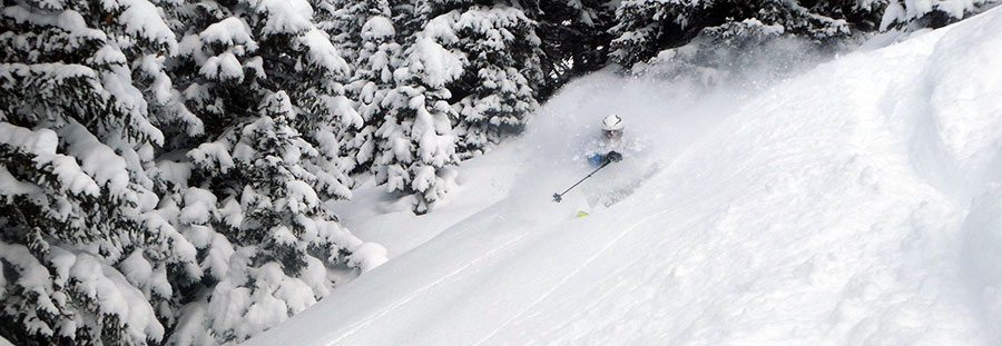
Learning to ski in St.Anton this week; picture (c) Snoworks instructor Lee Townend Huge snows for Austria, and snow moving into France now too. This Week's Snow Headlines - 10th January 2019 - Avalanche Risk Level at maximum (5) in parts of Austria as snow deluge continues. - Snow starts falling in the Western Alps. - Good snowfalls in Bulgaria greatly improve conditions. - Light snow in Andorra and Scotland, more edging into the forecast. - Big snowfalls in Western US - some ski areas report 1m+ (3 feet) in 72 hours in California and Utah. It's been quite a week for snowfall in the Alps and in North America with some huge falls on both sides of the Atlantic. Starting closer to home, snow is falling again in the Western Alps; for parts of France, Switzerland and Italy after almost a month of mostly dry weather. The snowfall here is expected to bring around 30cm to many areas which should be a good refresh for the slopes. But it's the eastern Alps, now into their third week of serious snowfall, that has been making news headlines outside of the usual ski press. Some areas have had another 3 metres (10 feet) in the past week on top of heavy snow the week before... and there's more snow forecast over the week ahead... Avalanche dangers are widely at level 4, the one below highest, and did actually move up to the highest, level 5, yesterday in several provinces including Salzburgerland and Styria. Along with heavy snow there have been strong 100kph winds at times. High glacier ski areas in the country have closed and other areas have limited the terrain they can safely open according to conditions. At the other extreme, largely snowless Pyrenees has now had a little fresh snow with more forecast. Over in North America the west coast has been hit by more big snowstorms, this time hitting further south with several Californian areas reporting more than a metre of snowfall in the first three days of this week and big snowfalls further inland too, if not quite so big (except for Sundance in Utah which also reported a metre). In the Alpine Forecast It's still stacking up in the forecasts for Austria, with a metre or more new snow expected over the next week for quite a few - already very snowy - resorts. This coming weekend should see some significant snowfall into the North-West Alps also, with many French and Swiss ski areas due for their biggest falls for several weeks. Accumulations could be substantial in some parts of the northern French Alps, including Chamonix. 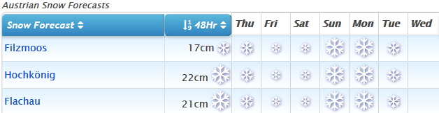
See where it's expected to snow this week...
EUROPEAN ALPS Austria Austria is battling with "too much snow, too soon" in some areas at present causing logistical and safety issues for skiers - both reaching resorts and then finding slopes open and safe to ski once they do get through. Most of the leading ski areas remain largely open, however, with some skiers enjoying incredible powder conditions – albeit with low visibility and blizzard conditions at times! A number of glacier ski areas have been closed, in some cases for nearly a week now, partly due to the snow but also due to the strong winds. If you're heading out; put safety first and take local advice - stay safe and have fun! France There's currently fresh snow falling in the French Alps and Pyrenees after the best part of a month with no snowfall. Up to 30cm is expected by the end of Thursday which should improve conditions dramatically. Not that they weren't pretty good, on-piste at least, as it was... "The snow conditions in Les Arcs are currently very good. Despite a long spell without snow, the cold temperatures have maintained the pistes ... with an excellent network of snow cannons" Tim Wilson, Erna Low's overseas manager told J2Ski.com, adding, "It's been hard to find any powder snow for a week or so but that's changing as I write with snow falling to the valley floor and due to continue through tomorrow and then clear up on Thursday. Despite this, we've been enjoying cold chalky, grippy snow on the off-piste around Arc 2000. There were still a few areas of hard-packed pistes in the lower sections of the resort but 90 per cent of runs are regularly open and skiing access to all sectors is good. That is all due to change with the fresh snow." Italy Italy has had the quietest week of the big four alpine ski nations with very little fresh snow reported other than at a few areas in South Tyrol bordering the 'Snowmageddon' areas of Austria to the north which reported 30-50cm of fresh snow. It's been dry in much of the rest of the country but the snow in the Western Alps is reaching some areas in the Aosta Valley and other areas of Western Italy whilst more central Livigno reported 20cm of fresh snow in the last 24 hours, its first significant snowfall for quite a while. Switzerland Switzerland has been a microcosm of the wider Alpine snowfall picture since Christmas with huge snowfalls in Graubunden canton in the East of the country (a few small areas posting over 3m/10 feet of snow in the past week there), whilst in the Valais to the West, nada. There has been snow falling in the West over the past few days, however, similar to neighbouring France with resorts reporting 5-15cm as of Wednesday evening, numbers likely to double by the morning which should freshen things up nicely. More centrally, in ski areas like the Jungfrau and Andermatt-Sedrun, there have been 30cm+ falls already, the latter now reporting a 4.8m (16 foot) base, the deepest in the world at present. Scandinavia A fairly quiet week for snowfall in Scandinavia with Norway, as usual, seeing the biggest snowfalls – but they're not that big! Bjorli, in the west of Norway, as usual, posted the biggest accumulation – 30cm. For most others it was 5-15cm. With the Alpine World Championships getting closer Sweden's Are reports a 43cm base, with about half its runs open and no fresh snow this week. Pyrenees Conditions remain challenging in the Pyrenees, especially if you're hoping for powder, as there's been no snowfall here for the best part of a month now and lower slopes are bare at some resorts with ribbons of white machine-made snow pushed down the mountainside to create the runs. Higher up, the good snowfalls in November and early December do provide better cover. There is potentially light at the end of the tunnel with some snow forecast for early next week. The major centres in Andorra are managing to keep a lot of terrain open. Scotland It's still a mostly snowless start to the season in Scotland with just the small patches of snow created by all-weather snow-making machines at Cairngorm, The Lecht and Glencoe currently providing some space for sledging and beginner lessons. There has been a dusting of snow on hilltops overnight as temperatures have dropped below freezing and there is the possibility of snow from Sunday, fingers crossed. Eastern Europe The heavy snowfall in Eastern Europe over the past few weeks has now extended its coverage as far as Bulgaria (and even Greece!) with 40-60cm accumulations, most recently at the weekend, really transforming conditions there and bringing top-to-bottom snow cover and leading the areas to open all their runs. Slovakia has continued to be the snowiest country in the region with one small area reporting 1.8m (six feet) of snow in the past week. North America Canada There were some big snowfalls in Alberta and BC at the end of last week adding 50cm+ to bases there and the past 24 hours has seen some of the biggest snowfalls of the season so far in Quebec on the East of the country. Mont Ste Anne reported a welcome 26cm in 24 hours. Whistler on the West coast got another 20cm in the same period though and it has had metres of snow since Christmas. In fact, it now has one of the deepest bases in the country at 265cm on upper slopes. It's all a great change from a month ago when it was struggling for cover, then the snow storms started! USA The biggest snowfall of the past few days in the US has been in California with ski areas reporting up to 1.2m (four feet) of snow – widely welcomed after a fairly dry period here and transforming the state to deep powder conditions. The snow has been falling over a much wider area with ski areas in Utah reporting up to a metre of snow and centres as far north as Jackson Hole up in Wyoming as well as down south at Sipapu in New Mexico all reporting one or two feet of fresh. Over in the East it's a mixed picture with still "warm-for-the-time-of-year" weather forcing some centres to close as not even their snow-making systems work, but further north centres like Killington and Okemo in Vermont have had 125cm (6 inches) of fresh snow in the past 24 hours with more falling. The week ahead is looking fairly quiet with not much new snow expected. |
|
Anyone used the Instructor Lead Guiding with the Ski Club of Great Britain?
Started by User in Ski Chatter, 9 Replies |
|
The Ski Club's offer does look good value but it's not directly comparable with an actual course. For starters, Snoworks aim for a maximum group size of 6 - I think I read that SCGB go up to 8 (can anyone confirm?); which is a large group to be off-piste with especially if they've literally rocked up together for the first time that morning. Most importantly though, for an actual course - whether Snoworks or not - the instructor will have a good idea of everyone's abilities after day 1 and will plan following days appropriate to that known ability level. A key element of the Snoworks courses is that they will move people between groups after the first session - to get that consistency. Definitely, if you just fancy a day or two doing "some" off-piste with an instructor taking you on a safe route, the SCGB's arrangement looks good value - but it's not really the same (as a course). But hopefully someone can chime in with an actual experience to save us all speculating... :lol: |
|
Last minute ski holiday 26 January - which resorts/bad idea?
Started by User in Ski Chatter, 5 Replies |
|
This would be a good season to do that! :thumbup: Check the dates of German half-term holidays (as it's an easy drive for them) just to be sure, but as the others have said that's a low-season week so you shouldn't have trouble finding accommodation. Piste conditions should be excellent for the rest of the season there now, but caution's going to be needed off-piste for quite a while so defo look to do that with a guide if you're up for it. Assuming you're DIY-ing, it might be worth bagging your flights if you're firm on dates as you should get good prices on those; flying into any of Innsbruck, Salzburg or even Munich will give you plenty of options (see the Airport pages here on J2Ski for the resort choices). |
|
Last minute ski holiday 26 January - which resorts/bad idea?
Started by User in Ski Chatter, 5 Replies |
|
You're over-thinking it... last minute is booking the flights on Thursday, flying Friday. 8) 26th Jan is over 2 weeks away; it might have stopped snowing in Austria by then, and it'll probably have snowed in France... What sort of skiing are you after? |
|
|
Total, utter, respect! :shock: |
|
Is it safe to ski in Austria? Yes, but... take care...
Started by User in Avalanche Safety, 4 Replies |
|
|
And the Steiermark Avalanche Bulletin

Full bulletin (in English) at :- http://www.lawine-steiermark.at/lagebericht/avalanche-bulletin
|
|