Messages posted by : admin
Snow Forecast for Transfer Day - Saturday 13th February 2016
Started by User in Ski Chatter, 8 Replies |
|
When we advised adjusting your route to avoid the bottlenecks... we didn't expect you to go to Scandinavia! :lol: Anyway, here's another useful link for live traffic in the French Alps :- - savoie-route.fr/ And if you're either bored or easily amused (or stuck at the airport, or on an autoroute), you can watch the snow ploughs going up and down the runway at Geneva every so often... zoom in on flightradar ... - http://www.flightradar24.com/46.23,6.11/14 |
|
Family ski holiday half term 2017 Which resort/ country??
Started by User in Ski Chatter, 14 Replies |
|
|
Oh, and Jim makes a good point about the lift passes; "Child" and "Teen" definitions vary massively and - considering the price of a weekly pass nowadays - this could give you a significant saving comparing one resort against another.
|
|
Family ski holiday half term 2017 Which resort/ country??
Started by User in Ski Chatter, 14 Replies |
|
Absolutely this... a little planning with DIY and you can travel out of peak times, miss the jams AND get an extra couple of days skiing on the two Saturdays... For the OP, to make your pound go further; look at driving to Northern Alps, places like Les Carroz and Morillon (Grand Massif) and Le Grand Bornand (Aravis) great for families and won't bash your budget too hard. You've said you can take them out Friday so definitely try and do that; Eurotunnel crossing will probably be cheaper than the Saturday morning. A little less traffic and you can do most of the journey on Friday, overnight somewhere cheap near the mountains, get up into resort first thing Saturday and have a relaxed day skiing... ...keep an eye on our traffic forecast thread for this coming weekend; snow and heavy traffic is going to mean some long journeys tomorrow - so watch it all closely and then plan to avoid the jams when you go next year! 8) |
|
Snow Forecast for Transfer Day - Saturday 13th February 2016
Started by User in Ski Chatter, 8 Replies |
|
|
Latest forecast update keeps it Wet for Saturday, White for Sunday, BUT...
It is CURRENTLY snowing in Geneva, and Geneva Airport reports 0C at ground level, and flights delayed. Autoroutes.fr reports "Denneigement" (Snow Ploughs!) already in progress across a wide area :- - On the A40 Autoroute approaching Geneva from Bourg-en-Bresse. - On the A40 from Geneva to Chamonix. - On the A41 South of Geneva toward Annecy. - On the A43 from Chambery into the mountains. The snow now underway, across a wide area, is expected to continue through tonight before giving way to rain tomorrow morning. Saturday's rain will likely be confined to daylight hours, so far as we can tell, before reverting to snow late Saturday evening. The snowline will be much lower on Sunday, compared to Saturday, and main routes will be affected in addition to resort access roads. CAUTION :- although we do expect widespread rain at valley levels tomorrow, local effects and air temperature variation WILL bring snow lower in some places. For access to much of the French and Swiss Alpine resorts, and the Pyrenees, this weekend YOU NEED TO HAVE SNOW CHAINS WITH YOU. Even if you do make it into resort without using them tomorrow, more snow (and colder temperatures than tomorrow) is forecast for the rest of the week. |
|
Snow Forecast for Transfer Day - Saturday 13th February 2016
Started by User in Ski Chatter, 8 Replies |
|
|
This morning's forecast updates have eased back on the likelihood of "Snowmageddon" for Saturday... there will be snow overnight tonight (Friday) and into early Saturday BUT temperatures look like being mild during the day so the snow line should be between 1600m and 2000m for most of the day; hopefully meaning that the main roads, at least, should remain passable.
It is the first weekend of both the main French and many UK half-terms, however, so heavy traffic should be expected throughout the day and you should be prepared for delays in and around the usual bottlenecks. Eurotunnel are currently reporting delays of 30 minutes due to an earlier faulty train causing cancellations but it's early days... 8) Some handy links :- - Eurotunnel Latest Travel Info - French Autoroute Traffic info on autoroutes.fr - Bison Fute gives handy traffic flow forecasts as well as current traffic, although their website could be clearer... Also available from Bison Fute is a detailed analysis of traffic flows in a downloadable document; it is in French but contains a couple of very useful maps of traffic density and advised North-South routes with likely bottlenecks indicated. Definitely worth printing off if you're driving down;
Get it here :- Panorama de l'hiver |
|
J2Ski Snow Report - February 11th 2016
Started by User in Snow Forecasts and Snow Reports, 3 Replies |
|
|
J2Ski Snow Report - February 11th 2016
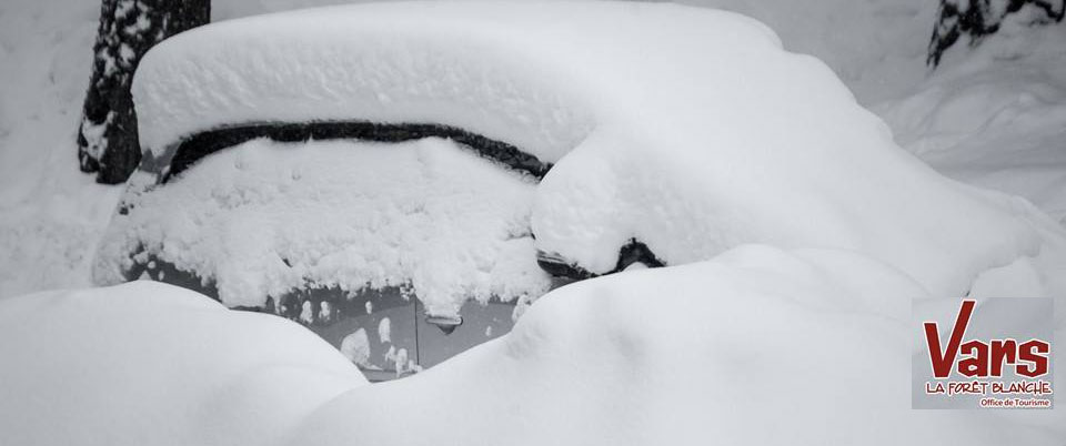
The Cars in Vars... were hard to find this week... There's plenty more snow to talk about this week, and a heads-up if you're heading to the mountains this coming weekend. This Week's Snow Headlines - After little snow all season, three feet of snow this week for St Moritz, including two days with 30cm in 24 hours. - Deepest base in Europe nears 4m mark. - Heavy snow in the Dolomites and the Eastern Alps at last. - Telluride reports deepest snow base for 10 years. - Up to a foot of new snow in Andorra It has been another snowy week in Europe with big snowfalls reported in the Alps and Scandinavia with resorts reporting accumulations of 30cm (a foot) or more in 24 hours, repeated over successive days in some places. Most notable has been snow in the Eastern Alps and Dolomites where it has been particularly needed. Some ski areas that had seen less than 30cm of snow up to last weekend in total all season have subsequently received up to a metre of snow in the last week. It's been a quieter week in North America although there's been yet more significant snowfall in the northwest - particularly Alaska and British Columbia - and some fresh snow in the East. In The Alpine Forecast There is now a decent amount of snow in the forecast for just about all European mountains over the next week. Heavy snow is expected over the weekend in the North / West Alps and Pyrenees, with lighter snow elsewhere. As with the week just gone, just about everywhere will see useful amounts of snow at some point, with a significant mid-week fall on the cards for Eastern areas that may miss out on the weekend snow party! Between the snowy days, next week should see a few more clear spells than this week, so - all in all - it's looking rather good for half-term, however... Possible Travel and Transfer Disruption Travel on Saturday, in and around the French and Swiss Alps in particular, does look likely to be in the firing line. If you are heading into (or out of) the mountains this weekend then you should be prepared for possible delays, and make sure you're fully equipped for snow-covered roads. We've posted a little more detail in our Forum here - Snow Forecast for Transfer Day and will update that post later as the forecast evolves. The Alps Austria Austrian ski centres have seen some healthy snowfalls this past week with up to four feet/1.2m accumulations reported on higher slopes and all resorts in the country posting at least 20cm of fresh snow, the majority nearer 45cm/18 inches. For areas in the far east of the country, such as Bad Kleinkirchheim down near the Slovenian border, it's been the snowiest week this winter with 30cm of fresh cover. Kaunertal was one of the snowiest resorts and now has a 3.9m (13 feet) snowbase, Europe's deepest and there's been another 90cm/3 feet of snow at powder centre Fieberbrunn. France French resorts have seen some of the biggest snowfalls in the world over the past week with lots of the country's altitude resorts reporting they have received between 60 and 120cm (2-4 feet) of new snow in the last week and the snow is still falling heavily. The Chamonix Valley, which now claims to have a 3.6m (12 foot) base on upper runs says it has received more than two metres of snow over the last seven days on its highest slopes. Snow depths are now looking good across the country with most resorts above 1500m boasting more than a metre of snow at resort level and over two metres at altitude. Further significant snowfalls are expected over the coming week too. Italy At last there's been heavy snowfall right across Italy, not just in the West, with the Dolomites in the East receiving their first significant snowfall of the season, completely transforming the area. A first wave of snowfall on Sunday/Monday brought 20-30cm of snow to many resorts in the region and a second heavier snowfall that built up over Tuesday/Wednesday brought 30-60cm more, meaning some areas have had more than 70cm in the past few days, transforming the region. Cortina reported the biggest accumulation with 40cm in 24 hours on Monday / Tuesday. However the West has been getting still more snow with Courmayeur reporting 50cm of snow in the same period. Cervinia, with a 250cm base, still has by far the deepest base in the country. Heavy snow is expected to continue over the coming week with up to a metre more forecast across Italy's ski slopes. Switzerland It has been another snowy week in Switzerland, particularly marked in the East of the country which had had a very poor snowfall season over the previous two months of winter 15-16. Up to a metre of snow has fallen in the area with St Moritz doing particularly well, recording two 30cm falls in 24 hour periods on Sunday/Monday and Tuesday/Wednesday. Engelberg has had 85cm (nearly three feet) of new snow too and its base, already the deepest in Europe and one of the few worldwide over 3m/10 feet on upper slopes has increased to 3.35m (11 feet, 2 inches). Andermatt has reported 95cm of snow in the last week and has also hit a 3m base. But all Swiss resorts have reported significant snowfall, most 50-60cm in the last week and none less than 20cm. Scandinavia More healthy snowfall in Scandinavia, particularly on Monday/Tuesday in Norway when Hemsedal, for example, reported a 26cm accumulation in 24 hours – about half of its total for the past week. Voss again topped the tables for snowfall in the country with another 50cm of fresh this week and now has a 1.5m (5 foot) base – the region's deepest. Are in Sweden beat Voss for snow this week though clocking up 55cm of fresh but its base is lower at 80cm – a similar figure to the larger ski areas in Finland which reported 15cm/6 inches of new snow since the weekend. Pyrenees The Pyrenees have enjoyed their snowiest week for some time with up to a foot of fresh snow reported in Andorra in the past few days. Grandvalira, the region's largest ski area, says that it is almost 100% open after it received 25cm of fresh snow in 24 hours on Tuesday/Wednesday this week. Eastern Europe It's been snowing heavily over the past 24 hours in Eastern Europe – particularly countries like the Czech and Slovak republics and Poland, where up to a foot of fresh snow has been reported. Borovets reports 20cm of fresh snow and it and Bansko in Bulgaria both have more than a metre lying on upper runs – the picture at Pamporovo is less impressive with 40-60cm. Scotland Scottish slopes are looking increasingly good after a tricky fortnight. The weather has stabilised and stayed cold, leading to some wonderful, clear blue sky, windless days. Glencoe and The Lecht are in particularly good shape and Nevis Range, Cairngorm and Glenshee continue to open more terrain as moderate snowfalls make that possible. The coming week is looking good with more of the same and if anything slightly lower temperatures. North America Canada A quieter week in Canada although again it's been the west of the country that has seen the most snow, particularly in coastal BC where Whistler reports another 60m/two feet of snow has fallen – the most of any major area this week. On the other side of the country there has been fresh snow on the Atlantic coast too with Mont Ste Anne reporting more than 20cm of fresh snow in the last seven days – it now has quite a healthy base. USA The world's snowiest resort of 2015-16, Alyeska in Alaska, got another 75cm of snow this past week taking its snowfall-this-season-to-date stat past the 12m/36 feet total. It also has one of the world's deepest bases at 371cm (Over 12 feet) but is joined in the 3m/10 feet plus club by Squaw Valley in California which has hit 305cm. Mostly though snow totals have been less than previous week with a few areas in Colorado and Utah (Steamboat, Snowbird, Alta) reporting around 30cm/a foot but most others nearer 10cm max. There's been some snow in the East of the country too with Sugarbush reporting 20cm in 24 hours on Wednesday. |
|
Snow Forecast for Transfer Day - Saturday 13th February 2016
Started by User in Ski Chatter, 8 Replies |
|
|
Here we go again - Traffic and Snow!
If you're travelling to or from the mountains in Europe this coming weekend, you need to pay close attention to the weather forecast. Heavy Snow is forecast for many areas, particularly the North and West Alps, and we expect to see between 10cm and 50cm over the course of the weekend for much of the French and Swiss Alps, the Aosta Valley and the Pyrenees (where some resorts could see a metre of new snow over 3days). Heavy Traffic also is in the forecast, as this is one of the main changeover weekends for half-term. Many areas have already seen heavy snow this week, which is continuing as we write. There will be a lot of precipitation over the weekend BUT the variable in the mix at the moment is the snow line; it's possible that some areas may see rain as high as 2000m at times, and snow as low as 1000m at others! Road conditions will be somewhat variable, as a result, but you MUST be equipped for snow covered roads into resort - winter tyres and chains. Be prepared for disruption to road and possibly air travel; food and water to sit out any delays, fully charge all your phone and laptop batteries so you can keep updated, and have everything you need where it's easy to get at... If you're driving, try to time your travel - and adjust your route - to avoid the likely bottlenecks. From the latest forecasts we're expecting the heaviest snow to arrive on Saturday but affected areas will very likely see snow through much of Friday and Sunday too. We'd advise travelling as early as you can, whether going up or down! If you've not got chains, then go and get some NOW! Don't wait until you get to Bourg Saint Maurice... And if you're heading out... be patient; you'll have a great time - there's heaps of snow! |
|
Åre in Sweden in mid-February
Started by Dobby in Scandinavia, 47 Replies, discussing Hemsedal and Trysil |
|
:lol: ...shame there's nothing steep there... |
|