Messages posted by : admin
|
J2Ski Snow Report 14th February 2019
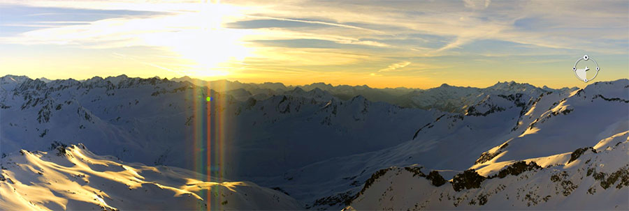
Sunrise from the Gemsstock, Andermatt, this morning... It's still snowing in the Western USA, but the sun's out in The Alps! This Week's Snow Headlines - 14th February 2019 - Huge snowfalls again in Western North America; up to 1.2m (4ft) of snow in 48 hrs. - Temperatures rising in the Alps after a snowy start to the week. - Very low temperatures cause operating difficulties at some resorts in Canada. - Scottish ski areas struggle with warming temperatures and strong winds. It was another snowy weekend in The Alps with snowfalls of up to 60cm reported right across the region up to Monday. Since then, however, sunny skies have prevailed in many areas. With the fresh snow and sunshine, conditions are close to ideal, on-piste at least. Off-piste, they're good too but the avalanche danger moved back up to Level 3 (Considerable) in many areas, after all the new snow. Temperatures are in fact currently expected to keep rising towards the end of this week across much of the Alps. This should make the weather very Spring-like but with deep bases built through January and the first half of this month this shouldn't do too much damage to snow cover. It's a similar story in the Dolomites, the Pyrenees and in Eastern Europe with sunny skies. A more mixed picture in Scotland and Scandinavia where it has been getting warmer too, but there's been a real mix of weather conditions along with it – not just sun. Over in North America after a quieter week last week heavy snowfall is back on both East and West Coasts with the Northwest corner of the USA seeing huge accumulations with the kind of volumes that block interstates and close resorts. In the Alpine Forecast Temperatures are expected to keep rising through the next week across much of the Alps. So it looks like a sunny and almost Spring-like half-term break, with great skiing on the deep bases built through January and the first half of this month. 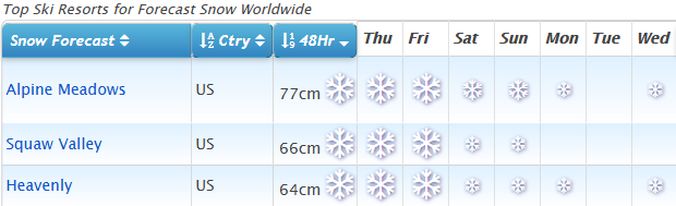
See where it's expected to snow this week... USA FTW right now!
EUROPEAN ALPS Austria Temperatures are rising in Austria after another snowy weekend and start to the week. Most recently the Saalbach-Hinterglemm-Leogang-Fieberbrunn ski area posted an 80cm snowfall and full on winter for the period from Sunday to Tuesday. Unlike in the huge snowfalls of early January however, the resort, like most others in Austria, is fully open. And now the snowfall has ended for the time being, the sun is out at most Austrian resorts and conditions are superb, although those wishing to head off-piste should beware the avalanche risk level is still 'considerable' (3). Many Austrian ski areas reported 20-40cm of snow between Saturday and Monday. The Kaunertal glacier has the country's deepest base at 5.6 metres – just under 19 feet. France It was a snowy weekend in the French Alps with the snow falling from Friday to Monday at most areas; the heaviest on Sunday. Most resorts reported between 20cm and 40cm of fresh snow but it reached 50cm in the Portes du Soleil around Morzine and Chatel and the Grand Massif (Flaine and Samoens). Since then the sun has come out here too for great conditions with fresh snow, although also with the avalanche danger currently at level 3, considerable, in many areas. For the first time this year J2Ski's snow forecasts are not predicting any snow anywhere in France (well, apart from 1cm at half a dozen ski areas in southern France). Italy Italy did not see as much fresh snowfall as the ski regions to the north, but its slopes are in great shape after the heavy snowfall at the start of the month. Here too there's almost no snow in the forecast for the week ahead, although the northwesterly Piemonte region down towards the Med may see the first of the fresh snowfalls when they come next week - with 10-25cm of snow possible for resorts like Limone and Artesina at the start of next week, although that's too far ahead for any certainty. Base depths look good across much of the country – 2 metres or more on upper slopes at Courmayeur, La Thuile, Livigno, Cervinia and many more. Switzerland It was a very snowy weekend in the Swiss Alps with reports of accumulations of up to 60cm (two feet) of snowfall from Saturday to Monday from Eastern Switzerland right across to the Valais in the West. Among the bigger reported accumulations at the country's bigger resorts Laax reported 40cm, Davos 42cm and Arosa 45cm of snowfall, Like the rest of the Alps the week ahead looks largely clear and sunny with no fresh snowfall forecast until early next week. Andermatt continues to post the world's deepest base at 6 metres (20 feet) on upper runs, but Engelberg isn't far behind on 575cm (over 19 feet). Scandinavia A real mix of weather in Scandinavia over the past week, with some areas reporting significant snowfall, others recording temperatures down to -30C below one day and then up above freezing a few days later. There's been low cloud, strong wind, in fact pretty much everything it seems, thrown at Scandinavian ski slopes, but nowhere any one thing for very long. The most snow - as often is the case - has fallen on Norway's coast with Voss reporting 26cm and Roldal 35cm of fresh snowfall in the past few days. Pyrenees After the big snowstorms that ended January and started February things have calmed down a lot in Andorra and the Pyrenees with little fresh snow reported in the past week and not much in the forecast either. However, rather ironically perhaps, unlike further north in the Alps, it looks like temperatures should stay low for the next week at least. Ski conditions are great across the region after all the aforementioned snow, with deep bases and mostly good weather conditions. There's a chance of more fresh snow at the start of next week but it's a bit early to say. Scotland Scottish ski areas are struggling a little this week with warm temperatures and strong winds. The latter has led to temporary closures and may impact the modest cover that has built up over the past fortnight. Currently, it's looking likely to stay well above freezing until at least Sunday so a thaw has set in. At the time of writing all five Highland centres were still operating with some terrain open. Eastern Europe Conditions remain good across much of Eastern Europe and Bulgaria and whilst the Alps are warming up. In Bulgaria, at least, it should stay cold in the mountains and well below zero into next week, there's even a little snow forecast. After the World Championships end in Are next week one of the first stops for the resuming World Cup tour is Bansko and the resort has reported that their Todorka, Tomba and Stara Kotva (7) runs will be closed until February 25th due to the preparation works for the races between February 22nd and 24th. North America Canada It may have stopped snowing in much of Europe but Canada is just getting started on a week of heavy snowfall after two weeks when there's not been a whole lot to report. Quebec is getting the heavy snowfall first with the region expected to get 50-60cm by the end of Thursday. Tremblant, which already had the deepest upper slope base in the country, reported 29cm more snow in 24 hours to Wednesday and is the first in the country to go through the 4-metre base depth mark, hitting 406cm. It's expected to keep snowing into the weekend in the east, although ease off in intensity from Friday. Snow forecast for the West too, the heaviest falls on the Pacific coast – 10-30cm more snowfall forecast. USA There have been some huge snowfalls in Washington State up in the northwest of the country following the snow in California and Utah last week (which are also resuming now and expected to continue for the next few days). Indeed it's a snowy picture across the US with some significant snow starting to fall on the east coast too with resorts there reporting 20-40cm of snow in the 24 hours to Wednesday. There's much more in the forecast for much of the country for the rest of this week and it's possible Mammoth Mountain, which currently reports the continent's deepest base at 533cm, might get up towards 6 metres (20 feet) if the expected 60cm/2 feet plus more snow falls there by Saturday. |
|
|
That looks like a reasonable day to be out! Enjoy! :thumbup:
|
|
|
J2Ski Snow Report 7th February 2019
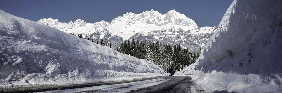
The road to St Johann im Pongau, dug out (again) this week! Big snow all over; from North America to The Dolomites and (most) all points in between. This Week's Snow Headlines - 7th February 2019 - Huge snowfall in the Dolomites; some areas reporting 2m+ (6ft+) of snow in 7 days. - Snow depths in the Pyrenees pass 4 metres after more heavy snow. - Heavy snow in Italian Alps, eight off-piste avalanche deaths. - Scottish ski areas open more terrain as snow falls and cold weather continues. - Huge snowfalls in California's Sierra mountains force ski areas to close. The last week has seen a lot of snow, falling pretty much everywhere in the northern hemisphere for once. The biggest falls in the Alps, Dolomites, Pyrenees and North America have each totalled over 2 metres in the period. The past few days, again almost everywhere, have calmed down though - with much lighter snowfall and more settled conditions prevailing now. It has been an unusual week for world snowfall in two key respects. First, there has been a lot of snow and it has been falling pretty much everywhere. The biggest falls in the Alps, the Dolomites, the Pyrenees and North America have totalled over 2 metres in each area in the same week. Second is the synchronisation – the heavy snowfall wasn't quite at the same time everywhere in the world, but it was pretty close, and by contrast, almost everywhere in the world, it has gone very quiet since the start of this week, with much smaller snowfalls, if any, reported in recent days. So a quick rundown. The latter half of last week into the weekend was snowy across the alps with the West seeing slightly more, but unlike previously, it was snowing pretty much everywhere, not on one side or the other. The avalanche danger hit Level 5 in places, maximum danger, and sadly there were some fatalities off-piste. The Dolomites saw their biggest snowfall of the season so far and it was the second week of heavy snow for the Pyrenees. There was snow in Scandinavia, Eastern Europe and Scotland too, the latter seeing ski areas able to open properly, at least partially, for the first time this winter. Across the Atlantic a massive snowstorm hit the Californian coast and raged from Saturday to Tuesday, burying, in some cases, cars and even chairlifts. Up to 3 metres/10 feet fell and several resorts were closed by the snow and strong winds but are returning to normal now. In the Alpine Forecast Clear and settled for the next couple of days, with temperatures in the mountains feeling mild at times, before the cold returns with - yes - more snow early next week. 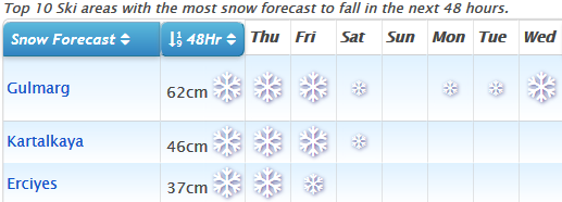
See where it's expected to snow this week... Kashmir and Turkey in line for the next few days!
EUROPEAN ALPS Austria Great conditions in Austria with the sun back out in most areas after a snowy week. That said, Seefeld did report 20cm of fresh snow on Wednesday morning and the picture is starting to look snowier again into the weekend. But right now pretty well every run is open at every Austrian resort after the snow-excess closures of January and the Kaunertal Glacier is reporting the country's deepest snow at 5.6 metres – nearly 19 feet. St Anton, which was posting the country's deepest snow a week ago, is on 525cm. France Superb conditions in the French Alps with the sun out after a snowy week up to last Saturday/Sunday. Ski resorts have reported 50-150cm of fresh snow in the past week so conditions are now fantastic and the avalanche risk has diminished from Level 5 (the highest) issued at the end of last week. The Grand Massif region around Flaine is posting the deepest base in the French Alps at 320cm, with Ste. Foy in second place on 285cm but bases are looking very healthy across the country. In fact, the very deepest snow, in a complete switch from the first 8 weeks of the season, is now down in the French Pyrenees (see entry below). Italy Italy had quite a week last week posting some of the biggest snowfalls in the Alps in the Northwest of the country and also seeing some huge snowfalls in the Dolomites in the Northeast – several resorts there totalling more than they'd received during the previous two months in just two days. In the West the heaviest snow for the entire Alps was reported at La Thuile with more than 2 metres. Similar numbers were posted by Cortina d'Ampezzo and Val Gardena. The Lombardy region between the two also reported huge accumulations. All the snow caused problems of course with ski runs closed across the north, including the famed Sella Ronda circuit in The Dolomites at the weekend, and the avalanche danger was extremely high. Sadly eight people died in several off-piste avalanche incidents, the majority around Courmayeur. Switzerland As with the rest of the alps, there's been little fresh snow in Switzerland in the past few days. The last reported on Sunday and Monday totalled 30-60cm in Graubunden and Eastern Switzerland. As with most other countries in the region, there are now generally great conditions with fresh snow cover and blue skies. Andermatt still has the world's deepest base at a reported 6 metres (20 feet) although that total hasn't changed for a few weeks now. Engelberg is in second place in Switzerland with 5.4 metres. Scandinavia It's clear and cold in many parts of Scandinavia, including the area around Are in Sweden where the Alpine Skiing World Championships are now underway. Here temperatures are -20C but otherwise racing conditions are pretty much perfect. There has been some snow though, particularly in Norway, where several areas have reported 20-30cm of new snow in recent days. Pyrenees The heavy snowfall in the Pyrenees has continued into a third week and at the start of this week several ski areas in the region were amongst those reporting more than 2 metres of snowfall in the previous 7 days. Cauterets in the French Pyrenees is reporting the deepest base in the country at 4.5 metres. Things are finally quietening down again now though with only light snow forecast occasionally for the rest of this week, although in the longer term it looks like there could be another heavy snowstorm at the start of next week. Scotland A continuing improving picture in Scotland where all five areas in the Highlands were able to open at least some terrain that was more than the small beginner areas open so far this season, for more experienced skiers and boarders to enjoy. There's been some fresh snow and the past week has seen mostly sub-zero temperatures for snow-making and whilst conditions are still fairly marginal, more and more trails are opening. The forecast for the week ahead is mixed with temperatures rising but also more snow forecast so hopefully temps won't rise too much. Eastern Europe It has been a snowy few weeks in Bulgaria culminating in a few days of light snow bringing 10cm or so of new snow through this week. Bases are looking really healthy after the January snowfall with Pamporovo reporting more than three metres (10 feet) lying from the top to the bottom of the slopes, but depths are healthy, if not quite so impressive, at the other Bulgarian ski areas too. Bansko and Borovets are both fully open. The week ahead no looks dry with conditions staying cold on the slopes but possibly going above freezing at resort level over the weekend. North America Canada Canada has had a fairly quiet week for snowfall compared to its southerly neighbour (of which more below) with just 10-30cm accumulations through the week and across the country. The deepest snow remains on the Eastern Side with Tremblant in Quebec reporting the snow more than 3.6 metres (12 feet) deep. There were some significant snowfalls around Whistler on the West Coast last week and a few 20-30cm 24-hour accumulations at resorts like Fernie and Sunshine on either side of the BC/Alberta border at the weekend but nothing much since. The week ahead looks very similar. USA Snowmaggedon hit America's West Coast on Saturday and kept dumping for four days, driven in on 100mph winds, so it wasn't pleasant, or very safe, to be outside, and a number of resorts closed for several days until it blew through. Mammoth reported the biggest snowfall totals of all hitting 3 metres (10 feet) by Tuesday evening, exactly as forecast. It was one of the areas that closed due to the extreme weather and has the continent's deepest base at 495cm. Other areas like Dodge Ridge, Sierra at Tahoe and Homewood all reported more than 2.5 metres of snowfall too. The snow wasn't confined to Colorado and there were huge snowfalls in Montana, Utah and other western states too with ski areas including Jackson Hole and Snowbird big beneficiaries. It was less dramatic on the country's East Coast, and a little warmer than a week ago when temperatures were often around -20, but there was still some fresh snow there too. The week ahead currently look much calmer across the country with no more big dumps in the immediate forecast. Until next week... send us your snow pictures! |
|
Socks are (probably) ok for getting around the village, but I honestly wouldn't risk them for the drive up. To be honest, the village itself is not exactly flat. Get some chains. If more snow arrives when you do, then you'll quite possibly be stopped by the Gendarmes down in the valley if you've not got chains with you. The road up has quite a few hair-pins, some of which have short steep bits, and there are some pretty spectacular drops you really don't want to be near if you're struggling for grip. You've got time to get some and have a quick practice fitting them (might even come in handy in UK, depending where you are! 8) ). |
|
|
Hi Matt,
They've just had a fair bit of snow, and there's more on the way, so quite possible/likely you'll need chains at some point - you definitely should have some with you in any case. Are you driving up today? Check out the car park... 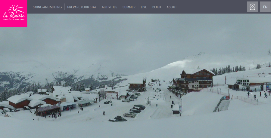
Live webcam at https://www.larosiere.net/en/webcam/la-maison-du-ski/ |
|
|
Very helpfully, James at Sauzeonline has posted a video of the black runs in question...
The latest we've heard is that the other runs are closed "indefinitely"? |
|
|
J2Ski Snow Report 31st January 2019
More snow for La Clusaz, French Alps, pictured this morning... More snow for The Alps, The Pyrenees, Bulgaria and also the Dolomites this week; still cold in the US and heavy snow for Japan. This Week's Snow Headlines - 31st January 2019 - Massive snowfalls in the Pyrenees (still continuing). - Scottish ski season starts, stops, then starts again. - Big snowfalls in the Alps - some French areas receive over a metre in 48 hours. - High avalanche danger (Level 4 of 5) in big snowfall areas. - Very low temperatures from Polar Vortex in parts of Eastern North America. - St. Anton upper slope base depth goes over 5 metres. It's been another snowy week in Europe's Alps, with the greater accumulations in the West rather than the East over the last seven days. But the really big snowfalls have been down in the Pyrenees; big news for the region as until about 10 days ago, many centres in the area had been struggling to open much terrain after several dry months. Now that has all changed. Another region that had been dry for the first few months of the season, The Dolomites, has also seen some snowfall this week with much more on the way over the next six days. Elsewhere in Europe, Bulgaria has had more good snowfalls and things are starting to look up at last in Scotland for the season there finally getting properly started. Across the Atlantic, it has been a quieter week with few huge snowfalls reported compared to previous weeks. A 'Polar Vortex' has been making things very cold in the Midwest and East. In the Alpine Forecast Much of the European Alps will see temperatures turn milder for a few days into this weekend... before it all turns cold again with the arrival of, yes, more snow. Substantial falls are expected, across a wide area, with ski areas in The Dolomites likely to see some of the biggest accumulations (50cm+ over the next few days). 
See where it's expected to snow this week...
EUROPEAN ALPS Austria Austria was hitting the headlines for huge snowfalls until mid-January, but we're now back into something like a 'normal winter' (whatever one of those is), with some regular snowfalls bringing more decent accumulations - just not metres at a time. So accumulations in the past week have been around 20-50cm across most areas in the country, with ski areas down in the south-east (Carinthia) which had missed out on the big falls earlier in the month also seeing more snow. Base depths in the North and West are some of the best in decades with most over 2 metres and quite a few posting more than 3 or even 4 metres of snow lying on upper runs. St Anton is top of the pile reporting 505cm up top. France French ski areas – both in the Alps and Pyrenees - have dominated Europe's snowfall tables over the past week. In the Pyrenees, several ski areas have posted 2 metre plus 7-day accumulations over the past week. At the time of writing La Mongie/Bareges had the biggest at 2.5 metres (more than 8 feet) and previously other areas in the region have reported as much as 2.9 metres in the same period but up to Tuesday or Monday. As the area had been suffering from too little snow this winter until recently it's great news for the rest of the season. In the Alps the heavy snowfall is more recent – really starting last weekend – but Megeve has posted three days out of the past four when it claimed a 50cm accumulation each time for a 1.5m (five foot) tally. Most other resorts across France have had big (if not quite such big) snowfalls. The results are lots of powder, low visibility, deepening bases, high avalanche danger and occasional issues with blocked access roads and buried lifts. The snowfall is expected to continue with more heavy falls at times through the week ahead. Italy A snowier week than for much of the past few months in Italy with the Dolomites receiving some decent snowfalls of 10-30cm and some snow in the West too along the French and Swiss borders. The stand-out resort here is La Thuile, right on the French border (in fact lift and piste connected to La Rosiere in France), which reports 1.4 metres of snowfall in the past few days, far more than anywhere else in the country and indeed the biggest single snowfall reported in Italy all winter. It is looking increasingly snowy for the week ahead too with parts of the Dolomites potentially seeing up to a metre of snow by this time next week – more than they've had during the season to date. Friday and Saturday look like the snowiest days. Switzerland It's been another often snowy week in Switzerland with resorts in the West of the country seeing bigger snowfalls than resorts in the East. The Swiss resorts of the Portes du Soleil have seen some of the biggest falls, posting 80cm of new snow since the weekend at Champery, Morgins and Torgon. Central and eastern areas still have the deepest bases in the country (and in Europe, and the World), however, with Andermatt still the only area on the planet so far this season to hit a 6 metre (20 foot) base on its upper runs. Engelberg is not far behind on 520cm. The week ahead looks like it will stay fairly snowy with moderate accumulations of 30-60cm on ski slopes across the country by this time next week, with the weekend looking the snowiest period at present. Scandinavia A fairly dry week in Scandinavia with a few centimetres more snow at many areas, gradually building bases ever deeper. Next week the FIS Alpine World Championships in Are, Sweden, will bring a global focus to the region. The base depth here is at around 70cm and about two-thirds of the area is open. Elsewhere ski areas in Eastern Norway have seen some of the biggest snowfalls of the past week with about 30cm more at resorts like Geilo, Hemsedal and Trysil. Pyrenees There have been the biggest snowfalls this season by some distance in the Pyrenees this week. As mentioned in the French section some French Pyrenees resorts claimed more than two metres of snowfall in the past week, but there have been huge snowfalls on the Spanish side and in Andorra too, and the snowfall looks like it will continue to be heavy through the week ahead too. Bases are building fast with most areas in Andorra now reporting around a metre at resort level (which had had zero snow until recently in some cases due to the dry December and much of January) and towards two metres up top. Scotland A frustrating week on Scottish hills but there seems to be light at the end of the tunnel. This time last week the season was finally getting started at Nevis Range and Glencoe with a few runs able to open after a week of cold weather, some snowfall and snow-making. But then temperatures shot back well above freezing, storms moved in, and we were back to square one to some extent. Since Sunday it's been sub-zero again, there's some fresh snow and this time The Lecht has opened some runs saying conditions are great. Cairngorm, Glencoe and Nevis Range also have some longer runs open now as well as the small areas for beginners and they're endeavouring to stretch to something more by this weekend all being well. Glenshee is currently open to school groups only but plans to open to everyone from Saturday, all being well. Eastern Europe It has been a snowy week in Bulgaria with bases building fast and some issues with lifts after all the heavy snowfall at the end of last week. Bases here are now between 1.5 and 2.5 metres on upper slopes with another 30-60cm of snow forecast over the coming week. A few quiet days are expected before the next dump begins at the weekend. Almost every run is open and every lift operating in the country. North America Canada Most of the snowfall reported in Canada over the past week, and particularly since the weekend, has been falling in the East, with ski areas in Quebec posting up to 30cm of fresh snow in the past 48 hours alone. Mont Tremblant, which has had 26cm in that period actually has the deepest base in Canada on its upper runs, and one of the deepest in North America, at 333cm (over 11 feet). That's some way ahead of resorts in BC (Whistler is on 242cm, one of the deepest in the West). The week ahead looks to be similar with not much snow forecast but there could be some sizeable falls towards the weekend on the Pacific coast including 50cm for Whistler and for smaller ski areas on Vancouver Island. USA After a mostly snowy January in Western USA, it has been a largely quiet week with smaller accumulations in the West than the East, on the whole, over the past 7 days. The story in the East and the Midwest however also continues to be the super cold, with temperatures dipping below -40 at times, leading some areas in states like Illinois, Wisconsin and Minnesota to close temporarily for safety reasons as they are unsure if machinery, as well as humans, can cope. Heavier snowfall is expected in the West next week and areas in Alaska already posted up to 5cm of snow in the last 48 hours. However, the accumulations are not expected to be huge – mostly in the 20-40cm range. |
|
Post a picture Barney! But feel free to enjoy the snow first... :thumbup: |
|