Messages posted by : admin
|
J2Ski Snow Report 14th March 2019
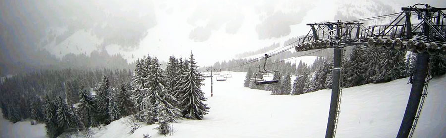
It's snowing in Les Gets, France, this morning... and many other French and Swiss ski areas too... It's been a very snowy week for many places, and there's more on the way... This Week's Snow Headlines - 14th March 2019 - California's Squaw Valley overtakes Switzerland's Andermatt for world's deepest snow base. - Ski resorts in the Alps report up to a metre of snowfall since the weekend, more falling. - Avalanche Risk Level back up to 3 (Considerable) in much of the Alps. - Scottish ski areas re-open terrain as cold and snow follows Feb thaw. It's been the snowiest week since the first half of January in the Alps with some ski areas in Switzerland posting a metre of snowfall already since the weekend, and if forecasts play out as expected, they may pass 1.5 metres (five feet) of new snow by next weekend. The biggest snowfalls so far have been in Switzerland and Western Austria but the snow is covering a wide area and bases are expected to build fast in France and the Western Alps too as the week goes on. It's not all powder though; strong winds have closed higher lifts at times, valley towns have had rain as well as snow and the avalanche risk level is heightened. Elsewhere in Europe, there's been some snow at last in the Dolomites and Pyrenees after a fairly dry month and more up in Scandinavia, where it has been snowy all winter (apart from Finland). It's been a week of storms and snowfall in Scotland with bases building fast on Scottish hills but, ironically, most of the centres that could now re-open, being kept closed by stormy weather rather than a lack of snow. Across the Atlantic the latest heavy snowstorms saw resorts in California finally overtake Switzerland to post the world's deepest bases at over 6 metres/20 feet. Colorado hit maximum avalanche danger when more than a metre of snow fell in a few days there but the storm seems to have finally blown out and conditions, at last, are looking fairly calm and dry. In the Alpine Forecast Heavy snow expected for the next 48 hours, across a wide area of Austria, Switzerland and the northern French Alps. Scattered, lighter snowfalls and clearer conditions in the days to follow. 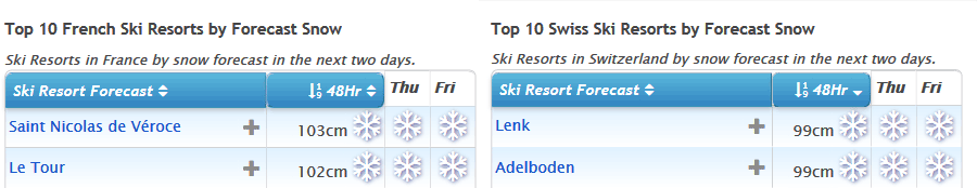
See where it's expected to snow this week...
EUROPEAN ALPS Austria Austria saw a third successive week with fresh snowfall in parts of the country around the weekend. This time is was Galtur in the west of the country, close to the Swiss border, that posted the biggest snowfall numbers – 90cm in total through the past seven days. But it has been snowy in much of the country and that looks to continue until the weekend when the snowfall should ease off. Thursday (today) and Friday look set to bring some big accumulations with several feet heading for the Arlberg and other ski areas in the West of the country – potentially the biggest snowfalls for several months. The deepest snow (and the bases have grown a bit this past week after several weeks of thawing) are on the country's glaciers with the Dachstein topping the table with 4.9 metres lying up there. France French ski areas have had a snowy week and it looks set to get snowier over the next 48 hours with particularly heavy snow forecast to end the week. Many areas are likely to get at least 30cm more snow, some as much as 60cm and for some as much as a metre over the next few days is possible. As it is, bases on higher slopes have made it back up to 3 metres (10 feet) above Les Arcs and Morzine with most other major French ski areas not far behind. At this time of year it's usually resort-level snow depth that starts to become more of a worry, but so far most ski areas look OK with 30cm+ at most traditional valley resorts and over a metre at the altitude resorts. Chamonix, where rain was reported in the valley at the weekend, is an exception though - reporting only a 5cm snow depth remaining on valley runs (there's plenty higher up though!). Italy Italy has had some snowfall through the past week with resorts like La Thuile posting a 35cm accumulation in 24 hours to Monday and fresh snow in the Dolomites at the end of last week, but so far not so much as at ski areas in Austria, France and Switzerland to the north and west. As with much of the rest of the Alps that's changing now with heavy snow falling and expected to continue up to the weekend, when a convenient lull is expected for transfer day before snow returns on Monday and continues into next week. If it all arrives as forecast we're looking at potential metre-plus accumulations at resorts like Cervinia and down along the French/Italy border, with sizeable, if slightly smaller, accumulations elsewhere in the 30-60cm bracket, with the dolomites likely to get another good snowfall. Switzerland Swiss ski areas have seen the biggest snowfalls of the past week, posting both the biggest multi-day accumulations since Sunday, the most ski areas reporting 20cm+ accumulations in each 24 hour period and now the biggest expected snowfalls over the coming week, particularly in the next 48 hours. It remains to be seen whether a Swiss resort will re-take top spot in the world snow depth table, a position held by Andermatt all winter until last weekend, but now overtaken by America's Squaw Valley. Engelberg, which has had 35cm of new snow in the past few days is coming up fast on 5.9 metres but Andermatt is forecast to get over a metre of snow – the biggest fall for over two months – so it may start finally increasing its stats again too. Scandinavia It seems to be getting snowier in Scandinavia as we move further in to March. It has been snowing across the region with increasing intensity over the past week and Wednesday saw reported 24-hour accumulations of up to 45cm in Norway with Gaustablikk reporting 70cm in 48 hours. There have been some good snowfalls in Sweden too so basically almost all of the ski areas in the country have a nice fresh covering and plenty of powder. The weather does look set to brighten up for the next few days so there should be sunshine to enjoy it all in. Pyrenees The World Cup Finals have just got underway at Soldeu in Grandvalira, Andorra, with some fresh snow falling and lower temperatures than recently. That said, it is due to warm up as we move into the weekend with double-digit temperatures at the base. But apart from potentially sticky snow conditions for racers, ski areas in the region are in fairly good shape with adequate base depths and all runs open. Scotland Snow conditions are gradually improving in Scotland, particularly on the West Coast where Glencoe and Nevis Range have been able to open terrain on their upper slopes – both on and off-piste – since the weekend. Ironically, though also rather typically, both were forced to close for much of the weekend though as winds were too strong to runs lifts, and currently that's an on-going problem. All five Highland areas have a re-growing snow-pack at present after the February thaw so it's currently looking good for more runs to open at more centres into the coming weekend. Glencoe and The Lecht also both re-opened several runs on Wednesday. Eastern Europe A mix of weather in Eastern Europe. It was very 'springlike' for world cup races at Kranjska Gora in Slovenia at the weekend but temperatures have dipped back below freezing this week in Bulgaria, where a thaw had been underway, and there have been some light snowfalls. Further north the Czech and Slovak Republics have been enjoying similar weather to the Eastern Alps and there have been some big snowfalls in resorts like Jasna and Tatranska Lomnica, reporting 20-40cm of fresh snow in the first few days of this week. North America Canada A snowy few days on both the Eastern and Western sides of Canada with more than a foot of snow across Quebec at the start of the week followed by similar accumulations on the west coast on Monday/Tuesday with Whistler Blackcomb posting a 29cm/24 hour snowfall. Tremblant now reports a 5.3-metre base, Canada's deepest by more than a metre. Temperatures have been creeping up from their usual Jan/Feb double-digits below zero to close to freezing now and even getting above zero at resort level every now and then at times. USA The US had another week of snowy drama into last weekend which culminated in the Colorado Rockies almost grinding to a standstill as high avalanche danger closed ski areas like Arapahoe Basin whilst actual avalanches blocked roads and even took out a gas pipeline near Copper Mountain leading to an evacuation. At the same time the snow kept falling over much of the rest of the country, and Squaw Valley, having just announced it would be staying open to July 7th this year, then announced its base had reached 6.3 metres (21 feet), finally overtaking Andermatt in the Swiss Alps for the 'world's deepest snow base this season' crown which Andermatt had held all winter. Since the weekend though, things have finally quietened down considerably, and it looks like the weather will continue to stay 'calm' across most of the US in to the weekend, so skiers can finally enjoy the powder with a bit of respite from the winds and snow. Of course it is still snowing, there have been 20-30cm overnight falls up in Alaska and Washington state in the past few days and similar falls are expected in southern states like Arizona and New Mexico, but for the main ski regions, much quieter. Until next week... enjoy! |
|
|
J2Ski Snow Report 7th March 2019
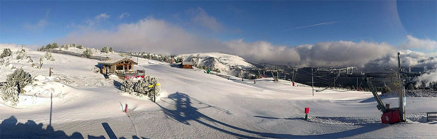
Looks like another fine day in Les Angles, French Pyrenees... Snow all over, sunny for some, and more snow on the way... This Week's Snow Headlines - 7th March 2019 - Fresh snow after 3-4 dry weeks in the Alps, Dolomites and Pyrenees. - More heavy snow in the USA as Colorado gets up to 1.2m (4 feet) of new snow. - March snow turns Scottish hills white again.. There's been a big change in the weather in the Alps (and indeed the Dolomites, and now the Pyrenees) after a warm and dry period that took up the last three weeks of February. It has turned colder for most places, the snowfall has returned, and all-in-all, now that (meteorological) spring is here, it has started to feel a lot more like winter than it did. It is a mixed picture, some ski areas in the Alps have now had more than 60cm (two feet) of snow over the past week, whilst others haven't had much, and the colder weather is only just arriving in the Pyrenees, but it does look set in for the week ahead in many areas with some parts of Switzerland currently forecast to get more than another metre of snowfall by this time next week. The version of winter we're getting in March isn't completely benign as the March wind has been blowing pretty hard at times, shutting more exposed higher lifts and runs on occasion. Elsewhere in Europe, it is staying snowy in much of Scandinavia and the snow has returned to Scotland after the record February UK temperatures, with areas optimistic that they'll soon have enough to start re-opening slopes. Over in North America, there have been more big snowfalls and low temperatures in the US. This week Colorado ski areas have topped the snowfall tables rather than California, but it has still been snowing there too, and over most of the rest of the country. In the Alpine Forecast Varying temperatures, but generally below or around seasonal averages, look to be the pattern for the next week or so... with a lot of snow mixed in. From today's forecasts, parts of Austria and Italy should get some good snow over the next few days, with the northern / western Alps (France and Switzerland) setting up nicely for some big snowfalls after a generally clear weekend. 
See where it's expected to snow this week...
EUROPEAN ALPS Austria Parts of Austria did have some snow early last week before the three week warm/dry spell ended everywhere else, and resorts like Saalbach in Salzburgerland are getting more snow now; with plenty more forecast for the week ahead – 20cm in Saalbach's case. But it is a mixed picture with some Austrian resorts only forecast to receive 10cm or so, others, including parts of the Arlberg and the Otztal Valley, as much as 50cm. Five of the seven deepest snow depths in the country are all on the glaciers and all amounting to four metres or more on upper runs. France French slopes saw some of the best new snowfalls at the end of last week with the Portes du Soleil, Paradiski and Grand Massif regions looking especially snowy and reporting 10-25cm of fresh snow. Cauterets, down in the French Pyrenees, is still reporting the deepest snow in the country at 3.2 metres, but that's down 80cm on a few weeks ago after the warm weather, although more snow is reported to be on the way here too. The week ahead looks snowy in France too with almost everywhere showing as likely to get at least a little snow almost every day for the next seven days. The only question seems to be, "how much?" and here the amounts vary from maybe 30cm in total almost everywhere to potentially 80cm in a few areas like La Grave and the Chamonix Valley. Italy There's snow at last for Italy too where most ski areas haven't seen any fresh for rather longer than resorts in Austria, France and Switzerland to the north. But so far there's been up to 20cm reported in the Aosta Valley and smaller falls further East in Lombardy and into the Dolomites, where the snow has arrived more recently. In fact, accumulations across the Dolomites over the next 48 hours should be 30-40cm before skies clear again for the weekend. In the Italian Alps to the West though the snow is expected to continue falling through the weekend adding up to 40-60cm accumulations by the start of next week. Passo Tonale still has the country's deepest base, reported at 4 metres. Switzerland Swiss ski areas have seen some of the biggest snowfalls since the weekend with Lötschental reporting the biggest accumulation so far with 58cm (almost two feet) of fresh snow. There have been good snowfalls across the country including at Andermatt, which has been posting the deepest snow in the world at 6 metres (20 feet) for most of this season and is one of those currently forecast to receive more than a metre more snow over the coming week. So will that 6-metre figure finally increase? Ski areas in the Valais in the west of the country have reported some of the biggest accumulations so far (20-50cm on average) but there has been snowfall almost everywhere and the week ahead is looking snowier still with almost everywhere expecting 30cm and some areas like Andermatt potentially more than a metre of snow. Scandinavia It's been snowing in Scandinavia fairly consistently over the past week following the mixed February conditions. The exception is Finland where it has stayed cold at least but there's not been much fresh snow to talk of. The biggest accumulations in recent days have instead been around Norway's coast, where up to 20cm of new snow has been reported since Monday. So there's powder condition in the west and smaller falls giving fresh cover on most of the rest of Norway and Sweden's ski slopes. Pyrenees Great relief in Andorra as, after a full month of often warm, dry weather, it is snowing once again in the Pyrenees. The fresh snow is well timed for the upcoming World Cup finals in Soldeu, so long as the weather clears in time for the races. In the meantime, it's very much business as usual with ski areas reporting decent basses still and more or less all runs open and all lifts operating across the region. Scotland It's an improving picture in Scotland too with snow on the hills again after the three-week February thaw, which was an extra bad one after Britain enjoyed record warm temperatures for the month. But there's now fresh cover across all five highland areas after the Western centres of Glencoe and Nevis Range got the most at the weekend. It's a little soon for them to re-open but the snow is still falling and currently expected to continue through the week ahead with the 20-50cm forecast, so hopefully, by this time next week, it will be a much-improved picture. As it is, for now, there are just the small beginner areas open at Cairngorm, The Lecht and Glencoe thanks to all-weather snow-making machines. Eastern Europe After the snowfall a week ago things have been generally settled and mostly dry on Bulgarian ski slopes over the past week. There's no real sign of change on the horizon there, perhaps a little light snowfall, particularly in Borovets, but generally, if anything, temperatures are rising at times well above freezing making a thaw more likely than fresh snowfall most of the time. But for now bases remain good and virtually all runs open. North America Canada Mont Tremblant in Quebec's base continues to grow, seemingly faster than they report snowfall, and is now up at 496cm on upper runs, tantalisingly close to the 5-metre mark and just a few feet below North America's deepest at present in California over on the continent's opposite coast. There has been some fresh snow in Quebec in recent days – just not too much – 5-15cm more widely reported. It's a similar picture for the week ahead although bigger falls are now being forecast for Alberta and BC with a 20-50cm forecast for ski areas including Big White, Sun Peaks and Whistler. USA After last month left California '#FebruBURIED' the focus this week has switched somewhat to Colorado where half a dozen ski areas including Aspen and Copper Mountain have now reported more than a metre of snowfall in the past 7 days. Breckenridge has posted the biggest total at 1.2 metres (four feet). But it has not just been Colorado, much of the US is battling with snowfall of the kind that goes beyond joy for skiers to misery for travellers with thousands of flights cancelled and a state of emergency declared in New Jersey at the start of the week, plus record March cold in the Midwest. And it is still dumping in California – just not quite so much as last week, or as in Colorado. But, in brief, there's some-to-a lot of fresh snow on almost every US ski slope. Until next week... |
|
Where to buy a ski chalet for half the price and with access to the same slopes
Started by User in Ski Chatter, 6 Replies |
|
No worries! :thumbup: |
|
We rarely use Tour Operators, so this is what works for us :- EasyJet fly out of 3 airports we can get to easily so we can usually find some wallet-friendly flights by being flexible with travel days/times; search for a hire car on rentalcars.com and then look for accommodation on Booking.com. Three websites and done on a good day. Sometimes have to add BA and Swiss to the search if EJ are short of seats or expensive, and Tourist Office websites are often good for looking for accommodation too. |
|
The essential questions are "when ?", and "package or DIY"? There are pretty much always last-minute options in off-peak weeks (especially pre-Xmas, early January and late March). Package deals at those times can be good, and there are often decent "early bird" offers around (Easter's a good time to look for these) as the Tour Operators know they'll struggle to fill some of those weeks. If there's poor snow leading up to a peak week then you can also find cracking deals if you leave it really late; a surprising number of people cancel last minute too. If you're happy to DIY it, then bag the flights as soon as you know your dates (easyJet, in particular, often start flights very low for early bookings) and pick your resort/accommodation nearer the time. Hotels can drop room rates quite spectacularly at the last minute too. ... but, as always... it depends! 8) |
|
|
J2Ski Snow Report 28th February 2019
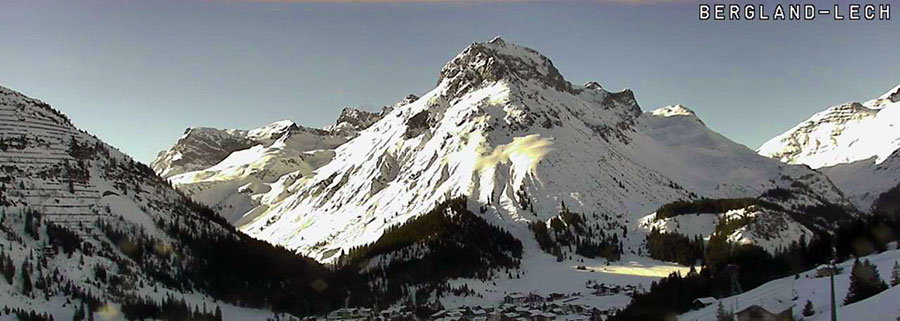
Lech this morning, in the lull before... the snow arrives tomorrow! Talk of Spring in The Alps was premature; winter's coming back! This Week's Snow Headlines - 28th February 2019 - Snowfall returns to the Alps with falls in Austria. - Jackson Hole reports 1m of snowfall in 48 hours on Monday/Tuesday this week. - World Cup cancelled at Bansko on Saturday due to heavy snow, run on Sunday instead. - Arizona ski area claims the biggest snowfall in America in the past week. Vegas gets snow too. - Ski resorts in Austria and Canada announce extended ski seasons. - Heavy snow in New Zealand three months before 2019 season due to start. - Heavy snow in British Columbia. After a warm, sunny February in the Alps conditions are changing back (as we enter Spring) to more wintry weather. Heavy snowfall is expected across the Alps on Friday and then again at the start of next week, so conditions should be well refreshed by the weekend. The snow is unlikely to reach the Pyrenees however, according to current forecasts, and the Dolomites will have to wait until the second wave next week. Scotland may get some respite as snow is expected here at the weekend and into next week. Across the Atlantic, it is currently dumping (again) in California, although with storm force winds shutting areas down whilst it goes through. It looks like already-broken February snowfall records will be beaten. There's been plenty of snow again in most other ski regions on the continent too with Jackson hole also expecting to break February snowfall records and some good accumulations on the East Coast. For novelty snow news this week there's been heavy snowfall in parts of the southern US that rarely see snow including Texas and Las Vegas, with Arizona claiming the biggest snowfall of the previous 7 days in the country up to last weekend. In addition, several ski areas in the Southern Hemisphere - including Mt Hutt and Mt Dobson in New Zealand - where it's currently summertime, reported a heavy snowfall over the weekend. The ski season starts in the country in June or July but Mt Hutt says they'll open for snow sports this weekend, a fairly unheard of scenario and a particularly ironic one for Scotland in the northern hemisphere where there's not enough snow for centres to properly open there. In the Alpine Forecast Although the forecast models are still very uncertain about exact snow quantities and timings, it is clear that temperatures are going cold across a wide area from tomorrow. An initial band of potentially heavy snow (tomorrow) will affect the northern and eastern Alps in particular, followed by further more widespread snow early next week - which looks set to continue for a while. 
See where it's expected to snow this week...
EUROPEAN ALPS Austria It looks like we're heading back into a period of snowy weather in Austria with moderate snowfall forecast across much of the country this Friday and Saturday, and then lighter showers into the start of next week. However Austria has, unlike the other Alpine 'big 4' nations had some snowfall in the past week too, with ski areas in Upper Austria and Salzburgerland reporting up to 30cm snowfalls at the end of last week, giving a boost to snow depths and (as they are pretty deep anyway), more importantly giving some fresh cover on top. Six of the 10 deepest snow depths in Austria (which range from 3.5 to 4.5m on upper slopes) are on the country's glaciers with Loser in Salzburgerland, one of the resorts that got a good snowfall in the past week, posting the deepest base of a non-glacier area at 4.5 metres (15 feet). France It has been more than a fortnight since the last snowflake fell on French ski slopes but that's about to change with snow forecast across the French Alps from Thursday onwards with the heaviest snow expected on Friday, before conveniently easing off for transfers on Saturdays and Sunday (if forecasts are correct) and coming down heavily again at the start of next week. Parts of the Chamonix Valley are currently forecast to receive 40-80cm and La Grave over 60cm of new snow. As it is, conditions on French slopes remain fairly placid with warm, sunny days continuing to be the norm, but thanks to accumulated bases, no great problems caused by the thawing so far. The fresh snow on top will certainly be welcome though. Italy Regular readers (and/or indeed skiers in Italy) may recall that there were some of the biggest snowfalls of the season across the country at the start on February, but there's been very little since. As with the rest of 'mainland' Europe, it has instead been largely very warm and sunny with great on-piste conditions (if a little too warm and wet by lunchtime), but with no off-piste powder left. The past week has been much the same but here too there is now snow in the forecast. Only really lights now on Friday compared to Austria, Switzerland and France although resorts in the Northwest around the Aosta Valley should get 30cm or so, then, although it is still a little far off to be certain, it looks like bigger snowfalls on Monday/Tuesday next week with the Dolomites getting a decent dump too that time. Switzerland As with much of the rest of the European Alpine region, snow is expected to start falling on Switzerland from Thursday onwards with snowfalls of up to 50cm possible by this time next week at some resorts, although it may be more like 10-20cm at others. Currently, the heaviest snowfall is initially expected to be in the west and centre of the country with the 4 Valleys and Gstaad region among those expecting bigger accumulations. Andermatt, which continues to post the world's deepest base this season at 6m/20 feet, is set to receive a 50cm top up. It, like other Swiss areas, has had warm, sunny weather for much of the past few weeks so the snow will be welcome here too. Scandinavia Most snowfall in Europe at the start of this week was falling in Sweden and Norway as again this region manages to keep the snow falling whilst most of Europe doesn't. Alas, that has not been the case in Finland though, which is reporting its warmest winter for 30 years. Riksgransen up in the Arctic Circle in Northern Sweden, where you can ski under the midnight sun in May, opens for its unusual ski season, which always runs through meteorological spring on Friday, 1st March. Pyrenees Andorra and the Pyrenees have had another snowless week and a particularly warm one with temperatures in Soldeu reaching 15C in the resort and even at the top of the mountain not getting below 5C some days. So there's some thawing but fortunately not enough to make a major impact on the base depths. Unlike the Alps, there's currently not any significant snowfall in the forecast either, although there are increasingly promising signs of some snowfall around Tuesday/Wednesday next week, perhaps 10-20cm. Scotland It's been another week of record-breaking February temperatures in Scotland with more of the remaining high altitude snow patches shrinking and the hillsides now almost entirely green and brown. There's some signs of colder weather and a few centimetres of snow at last at the weekend, then a more wintry picture next week as we move into spring (you know it makes sense), but it doesn't yet look like enough for areas to reopen. In the meantime, the purchase of all-weather snow-making machines by The Lecht, Glencoe and Cairngorm which are continuing to churn out snow for beginner slopes seem an ever wiser investment. Nevis Range is now talking about a similar purchase too. Eastern Europe There was the first fresh snow for several weeks in various parts of eastern Europe over the weekend. Bulgaria got particularly heavy snowfall with World Cup racing cancelled on Saturday in Bulgaria and 30cm of fresh snow reported for Bansko. There was also fresh snow in parts of the Czech and Slovak Republic as the snow fell in Austria to the south. North America Canada It has been a fairly snowy week in Canada, again, with the biggest snowfalls reported last weekend in Eastern BC, with both Big White and Fernie reporting more than 40cm of snowfall within a 24 hour period, resulting in deep powder joy. Fernie overtook Whistler to report the deepest base in Western Canada of the country's big-name resorts, although whistler has now gone back on top despite seeming to report less actual snowfall this week. Tremblant in the East continues to have the country's deepest base at over 4.5 metres. The coming weeks looks like mores now across the country though perhaps a little less than the past seven days with the biggest overall accumulations currently looking like 20-30cm for the start of spring. USA There have been more massive snowstorms in Western North America over the past few days as more resorts in the region report February 2019 their snowiest February ever. The latest heavy snow – with resorts reporting up to (another) 1,4 metres (nearly five feet) in 72 hours has again been driven in on strong gale force winds for full blizzard conditions meaning the practicalities of opening centre can be challenging and at resorts like Diamond Peak which have an on-going power failure, impossible. Plenty of snow a little inland from the Pacific coast too with resorts in Arizona and New Mexico reporting big snowfalls and Jackson Hole to the north clocking up over a metre of snowfall in 48 hours earlier this week – it's another reporting record February snow. There's been snow in the East too, although more like 20-40cm accumulations and here too accompanied by very strong winds at times. Until next week... enjoy! |
|
|
With the release of new package deals for NEXT winter (2019/2020), our partners Ski Solutions are offering a free Haglöfs Jacket with all bookings with a total value over £4,000.
Here are the full details, and some of the available offers :-
Full offer details are here https://www.skisolutions.com/1920-early-book-offer SAVE 13% (£180pp) – Stay for a week from 7th December 2019 for £1,145pp down from £1,325pp at Daria-I Nor, Alpe d'Huez, France.  
Five-star, ski in-ski out hotel Daria-I Nor in Alpe d'Huez opened in December 2018 and is the height of luxury, perfectly mixing traditional Alpine charm with modern grandeur. Each room has a spacious balcony, boasting unparalleled views of the breath-taking surroundings. The hotel also has a spectacular wellness area with two swimming pools, two saunas, a steam room, a hot tub, a salt wall and a solarium, which is the perfect place for guests to relax before they enjoy an evening in one of the hotel's decadent restaurants. What's included: Seven nights accommodation half board, return flights from London Heathrow and transfers. Find out more at Ski Solutions or call 020 7471 7782 SAVE 14% (£200pp) – Stay for a week from 18th January 2020 for £1,155pp down from £1,355pp at Panorama Upper Village Condos, Panorama, Canada. Due to their enviable ski in-ski out location, these luxurious and modern apartments make the perfect base for exploring the Canadian resort of Panorama. Ideal for families or small groups, the apartments have fantastic spa facilities ideal for guests keen to rest their legs after a day on the mountain. What's included: Seven nights accommodation only, return flights from London Heathrow and transfers. Find out more at Ski Solutions or call 020 7471 7782 SAVE 34% (£875pp) – Stay for a week from 22nd February 2020 for £1,675pp down from £2,550pp at Fairmont Chateau Whistler, Whistler, Canada. 
Situated at the base of the Blackcomb mountains and with easy access to the ski lifts, the Fairmont Chateau is one of the most sought after places to stay in Whistler. When not enjoying the extensive facilities available in this luxury hotel, guests can explore the vibrant village of Whistler that is just a short walk from the hotel. What's included: Seven nights accommodation only, return flights from London Heathrow and transfers. Find out more at Ski Solutions or call 020 7471 7782 |
|
|
Ok, so maybe make it an Espresso, but this might be the fastest descent we've yet seen of La Balme... 8)
|
|