Messages posted by : admin
|
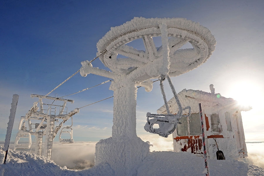
J2Ski Snow Report January 12th 2023
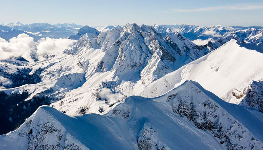
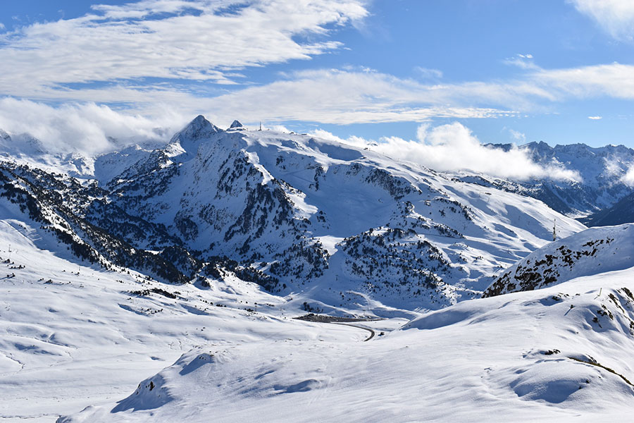
La Clusaz, France, just got a whole lot whiter... Snow fell, and more's coming... The Snow Headlines - 12th January - Colder temperatures and snowfall arrives in the Alps. - More huge storms push snow depths in Western North America towards 5 metres/17 feet. - Colder temperatures and snowfall finally arrive in the Balkans to the relief of Bulgarian ski areas. - Californian ski area reports 7 feet of snow in first 10 days of 2023. - Some snowfall in the Pyrenees and Portugal's only ski area is open. And there's more snow in the forecast for Europe and much of the northern hemisphere. 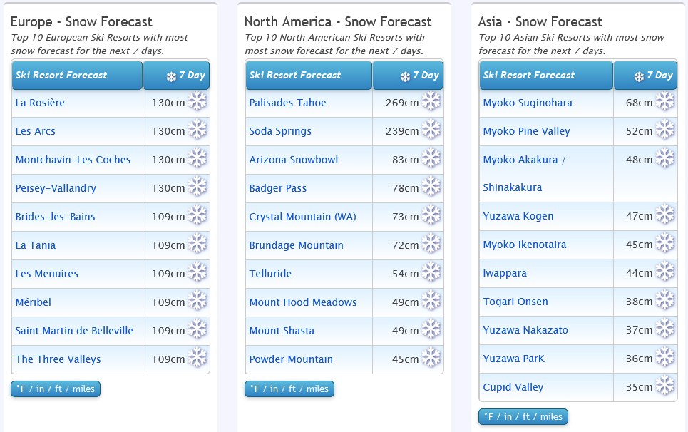
Big snow coming! Check where...
World Overview The main news of the past seven days has been the return of snowfall and colder temperatures in Western Europe. Ski areas in the Alps have reported up to 70cm of fresh snow up high since Sunday, more like 20-30cm in valleys. That's been enough to turn things around at low-lying resorts that had been suffering – Gstaad, Les Gets, Villars, Megeve and others to some extent although much more snow is needed. Fortunately, there's a lot more forecast after the weekend. Elsewhere there's been some snowfall in the Pyrenees but more is needed (and forecast), Scandinavia continues to look good and it's an improving picture in Scotland. The Balkans finally have snowfall and it's been cold enough for snowmaking in most areas too. Over in North America, more huge snowfalls in the west over the weekend and start of this week took base depths up towards 5 metres, the world's deepest still, in California but it remains a challenging time on the East Coast where resorts in more southerly states have been unable to open for lack of snow and cold weather and the bigger resorts of New England continue to face challenges too. Europe Austria Austrian slopes are in much better shape than a week ago with many areas posting 30-40cm of fresh snowfall in the last few days. The Skiwelt, including resorts like Westendorf, Ellmau and Soll warned skiers that, exceptionally, it would be making snow during the daytime in an attempt to pile it up as much as possible while temperatures were low enough, to maximise the change in the weather. That technique had, in any case, allowed it and other big Austrian areas like Arlberg and Saalbach to keep most of their runs open when ski areas at similar altitudes in France had struggled in recent weeks. Solden's base depth is creeping nearer to two metres up top, at 185cm now, the deepest in the country by some margin. France The best week for a month or so in the French Alps after heavy snowfall from Sunday to Tuesday brought up to 60cm (two feet) of snow to higher slopes and, more importantly for many ski areas, 20-30cm to lower slopes too at resorts like La Clusaz, Morzine and Megeve which had been struggling to open much terrain. Les Gets, which had had to completely close its slopes during the warm spell, re-opened a run on Tuesday and then half-a-dozen lifts and runs on Wednesday although the connection to Morzine and the wider Portes du Soleil remained closed at the time of writing. Italy There's been heavy snowfall along Italy's Northern and Western borders, with regions like the Milky Way and La Thuile-La Rosiere posting up to 50cm of fresh cover. Less new snowfall so far in the Dolomites but then they were already in pretty good shape having missed the temperature peaks and rain that hit further west. So the picture across the country remains fairly good with most areas 50-80% open. Switzerland Swiss ski areas have seen base depths jump by an average of 20cm over the past few days as they shared in the fresh snowfall across the Alps. Saas Fee continues to post the deepest at 1.8 metres (six feet) up high on the glacier. The new snow has not made a huge difference to what's open; Verbier had a little over half of the 4 Valleys terrain open and though a few more runs have opened, that's still the case - but with generally improved snow conditions. The avalanche danger level is up though, to 3 on a scale to 5 in many Swiss areas. Some lower centres like Gstaad which had been largely closed at the valley level have now been able to open more low-lying runs. Scandinavia Scandinavia continues to post the most consistently good conditions in Europe with Norwegian resorts looking particularly good – up to 1.5m of snow lying at Hemsedal, Voss, Geilo and others – much of it fresh since Christmas. There's been less for Sweden but up in Lapland, where temperatures have been in the -20s (Celsius), it just keeps snowing. Pyrenees Several fronts have brought light to moderate snowfalls to the Pyrenees over the past week. This has improved things a little with the largest Spanish resort in the region, Baqueira Beret, reporting 5cm (2") of fresh snow. Andorra's Grandvalira (Pas de la Casa, Soldeu) still has the largest area open, with about half its 240km of slopes open. Scotland There's been over a month now of mostly cold weather on Scottish hills and there's been more fresh snowfall over the past few days (accompanied by the usual gale force winds), but there's still not much of a base and Cairngorm, Glenshee and The Lecht still have a couple of short runs open each using their all-weathers snowmaking machines. Nevis Range doesn't currently have anything. Glencoe is the only centre with runs open with natural snow cover on its upper mountain at present. Eastern Europe The good news is after a month of often warm and dry weather in The Balkans it's turned cold and snowy in Bulgaria. Although there's a lot of lost ground to make up snow cannons are firing and Bansko reports 20cm of natural snowfall. Further north Jasna in Slovakia already had 20km or so of slopes open and the fresh snow there has further improved conditions. North America Canada Eastern Canada has been seeing the best of the fresh snowfall over the past few days, finally getting the combination of cold temperatures and precipitation needed after months of cold but dry or warm but wet weather, so conditions are the best of the season so far. It's more consistently cold and snowy out West, with more snow accumulating on the slopes of Alberta and BC. USA It's been still more snow, snow, snow in the Western US with a spate of records announced as the latest huge storms move in from the Pacific. Mammoth says it has already had more snow than the whole of last season while The Palisades says it has had seven feet of snow since January 1st. The Rockies are in great shape too, with Snowbird in Utah passing the 300 inches (7.5 metres) seasonal snowfall to-date mark. So plenty of snow; the main issue now is the volumes and stormy weather making it difficult for resorts to open much, although we're currently in a few days of clear weather before the next huge storm rolls in. It's a very different picture on the East Coast however where, unfortunately, it is more like the Alps with ski areas struggling to open runs due to periods of warm weather. Next week's looking increasingly interesting for Europe, so keep an eye on our forecasts and we'll have more detail next week... |
|
No other explanation makes sense Daved! Timed your trip nicely... 8) |
|
|
J2Ski Snow Report January 5th 2023
Park City, Utah, USA got their year started nicely... Snow in Europe, but more in America. The Snow Headlines - 5th January - Snow forecast for the Alps from the weekend. - More big snowfalls and wild weather in Western USA. - More rain to mid-mountain in parts of the Alps, but fresh snow higher up. - Scandinavian resorts post low temperatures and fresh snowfall. - Palisade Tahoe posts 95cm of snowfall in 24 hours to Jan 1st 2023. - More Scottish centres open more terrain. 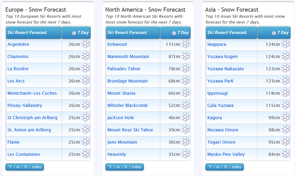
See where it's going to snow...
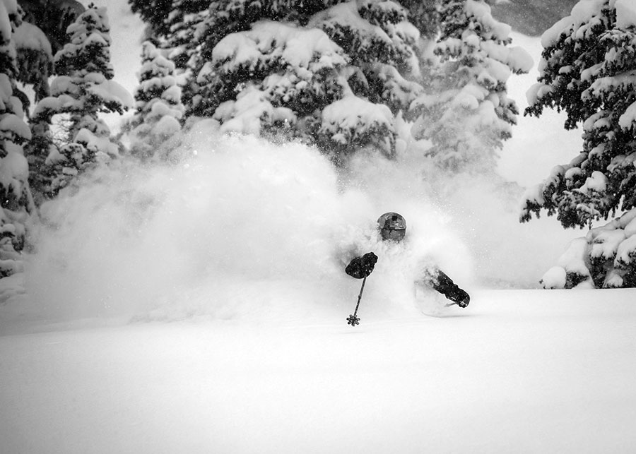
World Overview We're getting deja-vu in the J2Ski snow reporting team with the same weather cycles, it seems, starting the New Year as ended the last. But a change does appear to be in the air with increasingly confident forecasts of significant snowfall in the Alps from Sunday. For the past week though the most active weather systems have been slamming into America's West Coast bringing more short-term operational issues while at the same time building on what were already the deepest bases in the world this season. In the Alps the operational difficulties are, unfortunately, being caused by mild temperatures with a repeat cycle of rain for New Year weekend on slopes up to about 2,000 – 2,500m, though thankfully with not quite so serious impact as the heavier and sustained rain at Christmas weekend. There was also snowfall again higher up so conditions above about 2,000 metres are generally pretty good, but more challenging at lower levels. Colder weather and more significant snowfall is expected at the start of next week. Elsewhere the Pyrenees have similar issues to the Alps (although there was some snowfall here on Monday) and it's worse still in the Balkans where there's been almost no snow and it has been warm and sunny. Further north though cold and snowy weather in Scotland has allowed most areas there to open some terrain and Scandinavia actually seems quite wintery! Europe Austria Austria has had a fairly quiet week with a little light snowfall for the New Year but predominantly dry and frequently sunny weather. Bases remain thin and the mild weather is challenging but the big ski areas like the Arlberg, Skiwelt and Saalbach Hinterglemm are each managing to keep about 200km (125 miles) of slopes open. The best conditions continue to be on glaciers with Solden currently the stand-out for top to bottom snow cover and open terrain. But the whole country, like the whole of the Alps (and the Pyrenees), could do with a fresh big dump of snowfall and some consistently cold temperatures. There is snow forecast for next week, but probably 15-30cm accumulations, less than further west. France Another less-than-ideal week in the French Alps with more rain and mild temperatures over the New Year weekend – although not so much or so damaging as a week earlier. There was up to a foot of snow above 2500m so high areas like Val Thorens, Tignes and others are in much better shape, 60-80% open and actually reporting pretty good conditions. The good news is the heaviest of the forecast snow this coming week is expected in France with 30-60cm falls expected between Sunday and Tuesday along with sub-zero temperatures to the valley floors. Italy The Dolomites have been dry for weeks now and snow cover remains fairly thin, but conditions are reported to be among the best in mainland Europe because there hasn't been any rain and while not cold, it hasn't been so mild as further north and west. Over in the north and west of Italy, there have been the same issues of mild temperatures at low altitudes but few have suffered the rain problems. The Milky Way region over on the French border has about 75% of its slopes open and conditions are reported to be very good on the Cervinia-Zermatt cross-border slopes. Colder weather and snow is expected here too from Sunday. Switzerland A largely dry week for Switzerland too with just some light snowfall up high earlier in the week. As with the rest of the Alps, there have been 'mild air issues', particularly at low altitudes, but resorts like Andermatt and Saas-Fee are posting some of the best snow depths in Europe on their higher terrain. Again as with the rest of Europe, higher Swiss slopes, particularly above 1800m altitude, are reported to be in good shape on the prepared slopes at least. And temperatures are dropping and there's snowfall now in the forecast at last, heaviest in the west. Scandinavia Scandinavia is the one part of Europe, (well perhaps also Scotland) that actually feels 'wintery' with temperatures well below freezing day and night and plenty of fresh snowfall. Hemsedal in Norway reported powder conditions for New Year weekend while Levi up in Finnish Lapland was excited to see the sun reappear above the horizon for the first time on New Year's Day. Much more snowfall expected daily over the coming week. Pyrenees The Pyrenees are facing similar issues to the Alps with temperatures too high much of the time and little fresh snowfall – although one front did bring a few inches high up earlier this week. But the amount of open terrain in most areas is unfortunately now less than it was in mid-December due to the loss of cover on lower slopes. Andorra's Grandvalira has the most open. Scotland Scottish ski areas have regained a lot of the lost ground from the pre-Christmas temperature spike now. The open terrain at each area remains limited but Cairngorm, Glencoe, Glenshee and the Lecht each had two or three runs open for the New Year's weekend and there's been more cold weather and snowfall since …but also rain at times. Eastern Europe There's a continuing north/south divide in Eastern Europe with ski areas in Slovakia and the Czech Republic like Jasna and Spindleruv Mlyn reporting most of their terrain open, fairly cold temperatures and even a little fresh snow. Things are unfortunately still very difficult in Bosnia, Bulgaria and other more southerly ski nations where it remains predominantly warm, dry and sunny. The only snow is being machine-made in the middle of the night when temperatures have been dipping to -5 or -6C. North America Canada It has been a weather roller coaster for Western Canada over the past week with ski areas battling against gales, heavy snowfall and icing conditions as temperatures fluctuated between -25C and +5C as fronts moved through. Big White and Whistler were among areas that seemed to face particular issues getting lifts working and opening terrain, issuing repeat apologies and thanking skiers in the resort for their patience. But overall the snow depth numbers keep increasing which is clearly good in the long term for the rest of the season. There's a more mixed picture in the east of the country. After Storm Elliot deposited up to 60cm (two feet) of snow on the slopes it has unfortunately got much milder and some lower slopes have seen the snowpack damaged by rain. Overall base depths have increased though and there's more terrain open than a week ago. USA The Western US, particularly the Pacific Coast has once again seen violent storm systems slam in from the Pacific, dumping several feet more snowfall on the Sierra Nevada, Cascades and Rockies. These mountains were already posting some of the deepest bases in the world (Mammoth Mountain the very most at present) so the new snow has just increased the differentials. It didn't float gently down though and was once again driven in on 100mph winds and, sometimes mixed with freezing rain. So resorts battled high avalanche danger, critical tree well risk, iced-up lifts and many more issues while outdoor New Year celebrations were cancelled. As with Canada there's unfortunately been a return to warmer weather and some rain after the big Christmas storm, but ski areas like Jay Peak in Vermont and Whiteface in New York state have missed much of the wet stuff and are still reporting good powder conditions. |
|
|
Just been catching up with the latest forecast model outputs and it's definitely looking wintry into the start of next week. For the northern French Alps, average temperatures should drop around 10C Sunday into Monday and there's likely to be some heavy precipitation at the same time - so could be some heavy snow fall, but possibly quite localized, potentially to low levels.
Temperatures may vary around the middle of the week, but with more precipitation queuing. Going higher than Morzine's slopes will get you the best of what's coming; Avoriaz should be good but as you've got a car then I'd suggest keeping an eye on Flaine and La Clusaz - both of which can pick up more snow than nearby areas, depending on timing... If you check out this page -> Snow forecasts for the Rhone Alpes resorts, and scroll down, there's a table showing you what's expected where and when. Likely to change a lot, and it'll be all about the freezing level / snow line, but you'll be able to find some snow! |
|
|
It's wet down low right now (see Morzine Webcams ).
However... the weather is forecast to cool significantly from the weekend and there's snow coming. Doesn't look like a huge dump soon, but it's a start and may get revised up. ( Morzine forecast ) From reports on Facebook it looks like Avoriaz is ok but should be much improved by next week. HTH. |
|
|
J2Ski Snow Report 29th December 2022
Big White, BC, Canada after a 30C temperature change... Snow in Europe, but more in America. The Snow Headlines - 29th December - Snowfall at high altitudes in the Alps, but unfortunately rain at high levels too. - Mega Storm Elliott freezes North America and brings more snowfall to many. - High avalanche danger in the Alps as warm, windy and wet impacts snow cover. - Bulgaria continues to struggle to open much terrain. - More snow in Scotland. 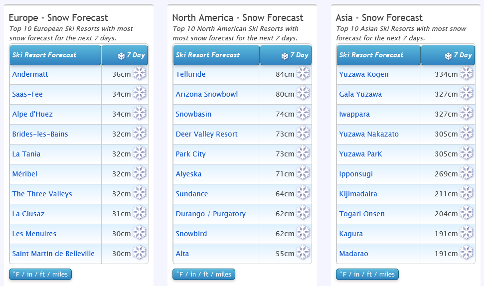
Japan's just showing off now...
World Overview The winter weather is certainly keeping us on our toes this week with lots of different extremes to report. In Europe, unfortunately, warm temperatures continue to impact lower slopes, with rain, strong winds and mild air also leading to high avalanche danger. Above 2,000m conditions remain pretty good though, as they do up in Scandinavia. By contrast, though there's almost no snow down in Bulgaria. North America has seen a really dynamic weather mix as has been widely reported in mainstream media with very low temperatures and some significant snowstorms. This time the East of the continent has ended up with some of the best accumulations so it is an improving picture there. More storms are now hitting the West. Europe Austria A very mixed picture for Austria with altitude a key factor as to whether you'll find good skiing or not. The northern Alps have, unfortunately, not seen much of the December snowfalls and it has also been warmer than the seasonal average in valleys. The result of this unhappy combination was a green Christmas in valleys and wet snow on higher runs for many of the Austrian areas topping out below 2000m altitudes. On the other hand, those with runs up towards 3000m are in good shape. Solden is the real stand out with almost twice as much snow lying as almost any other Austrian resort and virtually all of its 150km of slopes open. France French resorts continue to post the deepest snow depths in Europe, although they've lost their dominance of the top 10 with some Swiss resorts moving in there. But Alpe d'Huez, Puy St Vincent, Tignes, Val d'Isere and Serre Chevalier all remain in the top 10 for snow depth with 1.5 – 2.1 metres lying each. It's been a challenging week with rain up to high elevations for Christmas weekend and the thin snow cover lying on valley slopes melting/washed away in some cases, but there's also been more snow up above 2000m, so it's very mixed and there's still some good skiing up high. The off-piste avalanche danger is high with the mild temperatures, rain and strong winds thrown into the mix. Italy Italy seems to have fared slightly better than some other leading ski nations during the warm weather. Ski areas have been opening more runs and some are now fully open. The Milky Way (Via Lattea) including the skiing at Sestriere, Sauze d'Oulx and Montgenèvre over the French border is reporting the most terrain open, over 250km of slopes. The cross-border Zermatt-Cervinia region has over 200km of runs open too. In the Dolomites, most terrain is now open with Val Gardena leading the pack with all 80 lifts running and all 180km of slopes open despite just a 1-2 foot base reported. Switzerland Swiss centres have the same scenario as those in the rest of the Alps – good conditions and fresh snow above 2,000m altitude at most resorts. At lower altitudes though rain and warm temperatures have thawed the limited cover. As most Swiss resorts have plenty of high-altitude terrains the conditions aren't too big a problem. But the issue has proved difficult for some resorts to avoid. Laax, for example, despite having slopes up to 3000m, has warned of narrow stretches of snow in places. Scandinavia Powder skiers looking for fresh snowfall would be best to turn their eyes north (or make it easier by just clicking on the applicable webcams) as Scandinavia is the place where the snow has been falling in abundance over the last week. Some centres have reported over half a metre of fresh snowfall. Norway has reported the heaviest snowfalls with several resorts including Geilo and Voss now posting snow depths of over a metre on their highest runs. Pyrenees Ski areas in the Pyrenees have been battling warm temperatures too and the amount of terrain open here has dropped a little compared to Christmas weekend. It's the same issue as further north in the Alps – too warm and too dry when it comes to fresh snowfall. The deepest reported snowpack, on the French side, is only 70cm but Baqueira Beret and Grandvalira both still report over 100km of slopes open. Scotland Scotland's season is improving again after the warm weather last week. It's been back below freezing and snowing again. The Lecht, Glenshee and Cairngorm all re-opened some slopes on Boxing Day and snowfall continuing through this week led Glencoe to aim to join them on Wednesday. Alas, it was thwarted by rain late on Tuesday evening rather than the snow forecast. Eastern Europe Unfortunately, the warm weather in Europe's southeast continues to severely limit what ski areas can offer. Most Bulgarian ski areas have opened now but with just a few short runs created during snowmaking windows overnight and Sarajevo's ski slopes in Bosnia remain closed. It's a brighter picture further north where larger Czech and Slovak ski areas like Spindleruv Mlyn and Jasna have been opening more terrain despite the warmer-than-ideal temperatures here too, very much like the Alps. North America Canada Western Canada's period of super-low temperatures largely eased over Christmas weekend and it got up to the mere minus 5-10s (Centigrade) in Alberta and Eastern BC. However fresh storms arrived earlier this week, hitting coastal resorts like Whistler Blackcomb hard - which had to largely close as gale force winds hit along with rain and snow. It has largely reopened now though. Further inland there were reports of 10-30cm of fresh snowfall after the cold but dry weather and Big White noted problems with ice build-up on lift machinery as temperatures fluctuated through 30 degrees below freezing. Eastern Canada has seen a dramatic improvement in what had been poor early-season conditions with many areas receiving half a metre or more of fresh snowfall from Storm Elliot. USA The big weather story this past week was Storm Elliot which passed right across the US from west to east bringing bitterly cold weather, gale-force winds and, most markedly in the Midwest and northeast – plenty of snowfall. In the East that transformed the previously lacklustre conditions into powder skiing. There was snowfall for the Rockies too and now a fresh series of storms, with the most optimistic forecasts pointing to another "up to eight feet" of snowfall by the start of the New Year, moving into the west. The problem with storms though is that while the snow accumulations are great news for the long term, in the short term gales, buried roads and lifts and high avalanche danger can all cause ski areas to shut down for a day or two. |
|
|
J2Ski Snow Report 22nd December 2022
So this was Alta, Utah, USA this week... Snow in Europe, but more in America. The Snow Headlines - 22nd December - Several Utah Ski Areas Report of 60" (1.5 metres) of snowfall in 7 days - Warmer weather in the Alps and much of western Europe. - Snowfall at last in Eastern North America – up to 3 Feet (90cm) reported. - Bulgaria's Bansko opens for 22-23 season, initially with no runs complete. - Very cold weather closes ski resorts in Western Canada, US Midwest. - Scottish ski areas open, close and open again. - "Weather bomb" forecast for eastern North America. 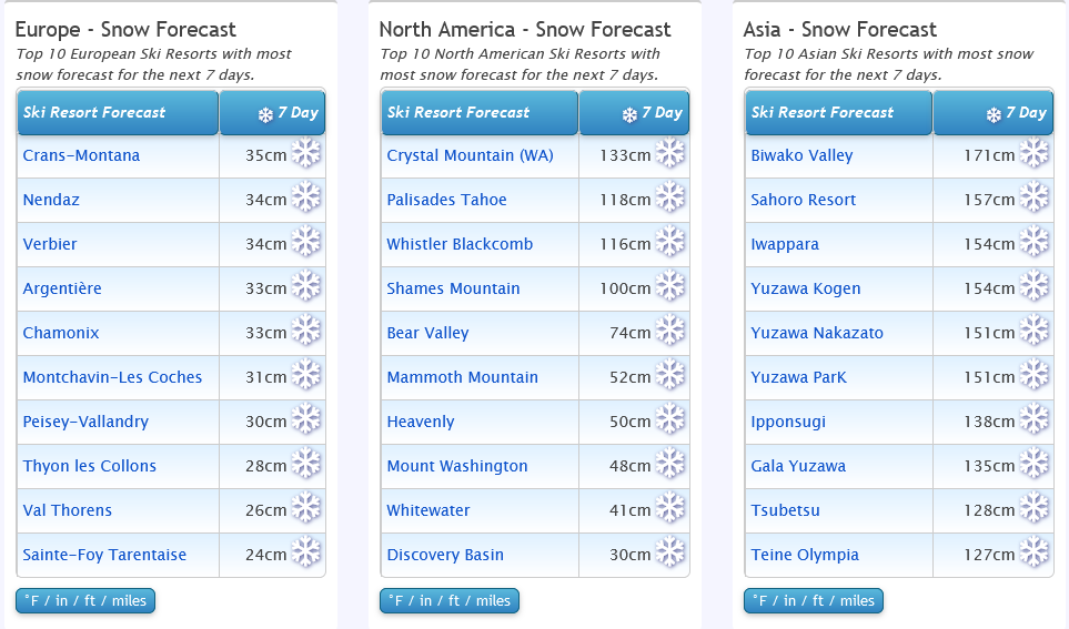
Japan and USA in the firing line...
World Overview We have passed the shortest day of the year and the days are getting longer (in the northern hemisphere). Up in Lapland it means the sun will reappear above the horizon at resorts like Levi in just a week's time. It also means we've entered winter by both the meteorological and now the astronomical measures of the seasons. One of the main themes in this week's report is temperature. In Europe it appears Mother Nature has not got the memo that we're in winter proper now and the freezing point in the Alps has been rising up towards 3000m. Not good news when lower slopes are in need of snowfall. Instead they've had rain although above 1800m the pistes are still in pretty good shape. In Northern Canada and Scandinavia it's the other extreme with -30C Celsius leading to lift closures and lots of 'stay safe' advice. The big snowfall news of the week comes from Eastern North America which has had a warm autumn and been unable to produce a lot of snow by machine for which the region is famous. However plummeting temperatures and up to three feet of snowfall over last weekend there has greatly improved things, and there's more on the way now. Europe Austria There's not been a huge change in conditions in Austria for three weeks or so now. There have been small to moderate snowfalls and spells of low temperatures for snowmaking but nothing too dramatic and unfortunately temperatures are a little high this week which isn't improving matters. Lower altitude runs are suffering the most and about a third of the country's centres - mostly the smaller, lower centres, are yet to open for the season. But most of the big ski areas have about half or more of their terrain open and good on-piste conditions. Ischgl, the Skiwelt (Soll, Westendorf, Ellmau etc) and Saalbach Hinterglemm Fieberbrunn all have about 160km (100 miles) of runs open each. France France has had the best of the December snowfalls overall, particularly the southern French alps with Alpe d'Huez and Puy St Vincent the only two resorts in Europe posting more than a 2 metre base up top. Not much fresh this week and warmer temperatures than we'd like but good on-piste conditions above 1600-1800 metres. Less to see off-piste and the avalanche danger has been quite high, Level 3 on the scale to 5, at a number of resorts. The 3 Valleys (Courchevel, les Menuires, Meribel, Val Thorens) have the most terrain open in the world at present, over 300km of runs. Italy About 80% of Italy's ski areas have now opened for the season and many are actually posting some of the best conditions in Europe, having been beneficiaries of the snow from the south earlier this month. Unfortunately they're now getting warm air from the south too. But most open resorts have a sizable swathe of terrain skiable. Dolomiti Superski offer the most but there's over 200km open on the Milky Way (Via Lattea) pass on the French border and 160km from Cervinia on the Swiss border too. Switzerland A similar mixed picture in Switzerland with most ski areas open now, those that are open offering ever more terrain available, but still issues for low slopes and rain reported up to about 2000m, although things are heading in a more wintery direction. The Portes du Soleil around Champery and the 4 Valleys around Verbier are posting the most terrain open, both now having more than 250km of slopes available. Saas Fee is posting the country's deepest snowpack at 1.6 metres. Scandinavia Midwinter in Scandinavia means little or no daylight with the sun below the horizon in a number of more northerly ski areas, including Levi and Ruka in Finnish Lapland, until the start of January. Temperatures have been reaching the -20s (Celsius) too. A real weather mix with some areas seeing lots of light snowfalls, others sunshine. The region's largest resort, Sweden's Are, has the most terrain open so far – about 30km of slopes – but that's still only about a third of its potential terrain. Pyrenees The Pyrenees are unfortunately seeing some very warm temperatures this week, getting into double digits at resort bases with lots of sunshine. This could be a problem for smaller, lower areas but not so much for the big destination resorts with higher slopes which are just seeing classic freeze-thaw conditions up high. Andorra's Grandvalira and Baqueira Beret in Spain both have the most terrain open in the region, about 130km (80 miles) of slopes skiable a piece. Scotland Scotland's ski season start was looking promising a week ago with constant sub-zero temperatures, if not a lot of natural snowfall to build a base. But after Glenshee opened half a dozen runs, the Lecht and Cairngorm had runs open at the weekend while Glencoe and Nevis Range had sledging. Alas the usual Scottish problem of a temperature spike bringing gales and torrential rain set these promising early signs back and closed slopes to start this week. But winter has returned and Cairngorm and Glenshee had limited slopes available again by Wednesday but with plenty of snow forecast for Christmas weekend. Eastern Europe The challenging start to the season in the south east looks set to continue past Christmas unfortunately with sunny, comparatively warm weather in Bulgaria, Serbia and elsewhere making it difficult to open much (any) terrain. Bansko officially declared itself open last weekend but without any complete runs unfortunately. North America Canada Western Canada has seen some very cold weather over the past week, particularly in the region where British Columbia borders Alberta. Most ski areas shut their more exposed lifts due to fear of mechanical failure and some areas including Jasper's Marmot Basin have been closed completely for several days. For those on the slopes the advice is to wear a lot of layers and cover exposed skin if you can as temperatures reach the -30s, then watch skiing buddies for signs of frostbite. USA After the heavy snowfall in the West of the continent a week ago it was finally the turn of the East to see big snowfalls over last weekend and the start of this week with most ski areas in New England and the wider area receiving at least a foot of snowfall, some parts as much as three feet. Big winners included New York state's Whiteface with big areas like Killington and Sunday River opening much more terrain. Things settled down on Tuesday but it has been very cold since. Drier in the West earlier this week but Mammoth is posting the world's deepest base and the only resort with over 3 metres (10 feet) of snow lying. A major storm system has now moved into the Pacific Northwest bringing more snow and forecasted very low temperatures and blizzard conditions into the Christmas weekend right across America. Ski areas in the Midwest in particular have announced 2-4 day closures because of the forecast extreme weather. |
|
|
J2Ski Snow Report 15th December 2022
Baqueira Beret, Spain, looking cool... Snow in Europe, but more in America. The Snow Headlines - 15th December - Good snowfalls for Western Europe – up to 65cm in the Alps. - Scotland's 22-23 ski season starts as UK hit by low temperatures and snow. - More huge snowfalls for Western US, up to 6 feet in 48 hours. - 3 Vallees opens for 50th season and has most terrain open in the world already. - Mammoth Mountain in California first to post 3m/10 feet+ base this season. 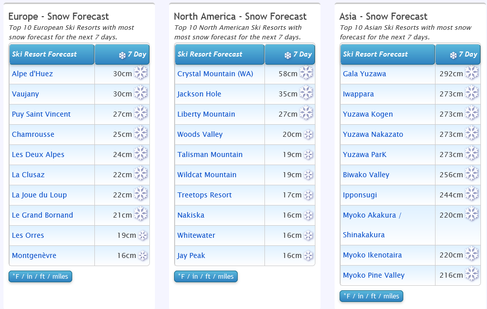
Ok Japan, you win (this week)...
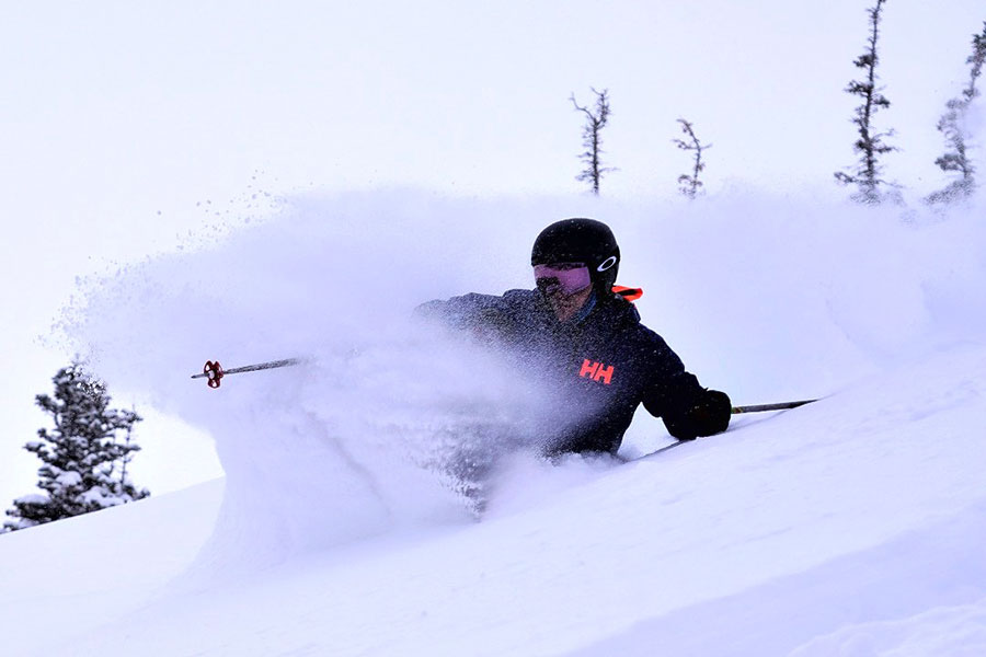
World Overview North America's Pacific Coast once again takes the world snow news headlines this week with further huge storms slamming into the mountains along the West Coast, bringing several feet more snowfall to the region which is already leading the world by some distance for early snowfall this season to date. In the Alps, there was a decent snowfall over last weekend, and it is starting to snow again now. Ski areas in the west, particularly the French Alps, saw the most snowfall. More and more ski areas opened and larger and larger amounts of terrain are opening at the centres already operational for 22-23. Elsewhere in the ski world, Japan's ski season is gathering pace, particularly on the northern powder island Hokkaido, which is living up to its reputation with more than a metre of snowfall at Niseko in the last seven days. Not doing quite so well in Nagano to the south but there are signs of improvements here too. Europe Austria Not quite so much snowfall in Austria as further west over the past week as the heaviest snowfall has been in the southern and western Alps, but nonetheless, there have been some light falls and low temperatures for more snowmaking. Ischgl, Sölden, Mayrhofen and Serfaus-Fiss-Ladis are each reporting more than 100km of slopes open already. There's still only about a third of Austrian areas open so far but most of the rest plan to join over the next two weekends. France France seems to have done about the best from last weekend's snowstorms with most ski areas in the French Alps reporting at least 30cm (a foot) of fresh snow cover and some much more – 65cm (over two feet) for Chatel and 50cm for Montgenevre for example. The snow arrived as more ski areas opened for the season, including Les Menuires and Meribel to complete the 3 Vallees opening for the 22-23 season, its 50th. The world's largest ski area had 155 runs open for its first weekend, and almost 300km of slopes, nearly half its maximum possible. This took it straight to the 'most open in the world' position overtaking recent leaders Ischgl/Sanaun and Val Gardena. Tignes and Val d'Isere also now have quite a large part of their terrain open. The snowfall was most welcome down at lower elevations, making it possible to open ever bigger vertical descents. Italy Italy sees the World Cup tour rolling in for its annual stops in Val Gardena, Alta Badia and others over the next few weekends. Conditions are looking pretty good here with most ski areas now open and quite a lot of fresh snowfall in the last week, as well as cold temperatures for snowmaking. Sella Neva over in the far east on the border with Slovenia has the deepest reported snowpack so far in Italy with 135cm lying up top. Val Gardena and Cervinia each have about 140km of slopes open, the most in the country at this early point in the season. Switzerland It's beginning to look a lot like ski season at Swiss resorts too, about a third of which are now open. Many in the west of the country have posted 20-40cm of snowfall in the last week. Ischgl/Samnaun's Silvretta Arena, the Portes du Soleil, Zermatt/Cervinia and 4 Vallées areas each already have at least 100km of slopes open. It should be a snowy end to the week with temperatures staying low as the sun returns at the weekend. Scandinavia It's mid-December and Scandinavian ski areas are living up to their cold and dark midwinter reputation with the shortest day of the year only a week away and some more northerly centres now hardly seeing daylight. Temperatures have been in the -10C to -30C range for many and there have been frequent snow showers. Most of the region's leading ski areas are now open including Hemsedal, Trysil, Geilo and the largest, Sweden's Are-Duved, many of them opening for 22-23 in the past week. Pyrenees About 80% of ski areas are now open in the Pyrenees including almost all centres in Spain and Andorra. There's been fresh snowfall this week and that, along with extensive snowmaking efforts, Has allowed centres to open a lot of terrain already. Andorra's Grandvalira (Soldeu, Pas de la Casa etc) and Spain's Baqueira Beret both already have over 100km of slopes open despite snow depths of less than 50cm. Scotland Scotland's season started on Monday with Glenshee opening several runs with a mix of machine-made and natural snowfall as temperatures in the Scottish highlands dipped as low as -18C. The Lecht saw access roads closed by snow but hasn't attempted to open yet. However, it as well as Glencoe and Nevis Range are expected to open this weekend, to some extent, Cairngorm next week. Although it has been very cold there's not yet been a lot of natural snowfall so it will be limited terrain initially. Eastern Europe It's a rather mixed picture in Eastern Europe. Bulgarian resorts have been reporting warm and windy weather which led several to delay planned openings for the season last weekend. However the largest, Bansko, wasn't due to open until this coming weekend anyway and although conditions are not yet brilliant (still a bit warm), they're improving. Further north though things do look better, Jasna, Slovakia's largest centre, opened its southern slopes at the weekend, although promptly had to close them again on Sunday as strong winds blew through. North America Canada Western Canada – particularly central and eastern BC and Alberta – has been posting great conditions for more than six weeks now. There's been still more snowfall, it has been very cold (as it should be mid-December) and Sun Peaks, Silver Star and most recently opened Fernie are all posting more than 100km of slopes open each already. North America's biggest resort, Whistler Blackcomb, only has about a quarter of its slopes open so far. Mount Seymour over on the BC coast is posting the country's deepest base to date at 1.5 metres. More challenging time in the east but the warm and wet weather has now eased off and it's very cold, great for snowmaking, with natural snowfall forecast too. USA The ski areas of the US are markedly divided in terms of conditions from west to east coast to extremes rarely seen. In the West, essentially, it's a remarkably good start to the season. Storm after storm has moved in off the Pacific leaving the snow metres deep, the deepest in the world right now in fact and snowfall totals way above average for mid-December. The whole region looks set for the rest of the ski season almost before it has begun. In the East it's almost the opposite, frequently warm and wet and ski areas struggling in snowmaking windows to make enough snow to open much. Resorts on both sides have been closed for periods in the past week – in the west due to more intense snow storms bringing avalanche danger and burying roads and lifts, in the East as it's too warm and wet to open some centres some days. |
|