Messages posted by : admin
|
Hey hey welcome back; always good to hear of someone getting back into it after a break...
For short breaks try Ski weekender (based in La Clusaz but may go elsewhere) or Ski Weekends? And, yes, Wickers may be our man on the spot in Spain (Sierra Nevada rather than Pyrenees). |
|
Les Arcs Snow in pictures - December 13th 2015
Started by User in Snow Forecasts and Snow Reports, 2 Replies |
|
|
Beau soleil again today - quiet pistes and good piste skiing with a little careful beside'n'between fun today. More later...
|
|
|
Don't sweat; as an "early" skier you really don't need metres of snow.
Les Deux Alpes, as you may know, is often referred to as an "upside-down" resort as many of the beginner runs are high up the mountain (particularly the runs up on "Cretes" and the blues on the glacier). You may have to take the gondola back down to the town at the end of the day but you should have plenty to keep you occupied. The other end of the weather spectrum for late December is perishing cold and bucketing snow... which is actually no fun at all for beginners/early skiers. |
|
Les Arcs Snow in pictures - December 13th 2015
Started by User in Snow Forecasts and Snow Reports, 2 Replies |
|
|
Pistes a little busier than yesterday, but a full day of great skiing under blue skies (after a little cloud this morning).
Thought I'd post up a few pictures to try and show the reality of the snow cover; above about 1700m it's actually pretty good and 99.9% of the pisted surfaces above Arc2000 are in good shape. So, as an example - here's the top of the Arondelieres red, that drops down from the base station of the Aiguille Rouge cable car :- 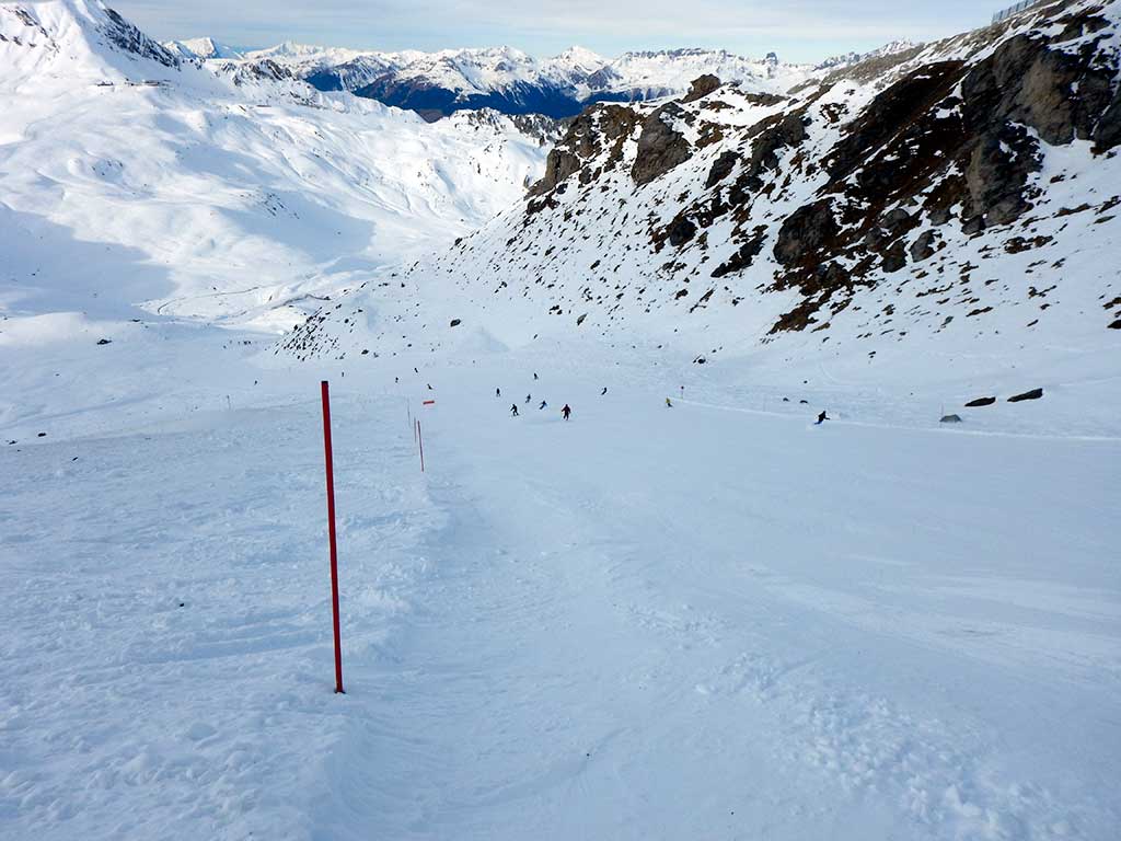
The off-piste rocks have been exposed to sun and wind, but the snow on the piste (and beside, in most part) is very skiable with a few cms of loose powder on a firm base... 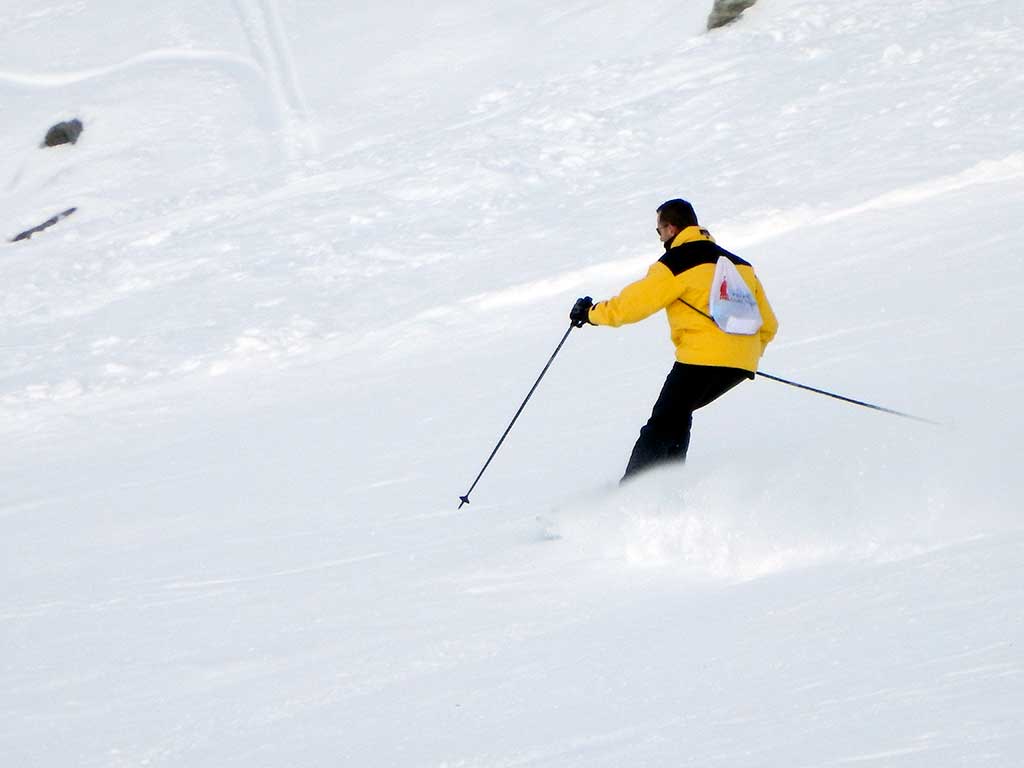
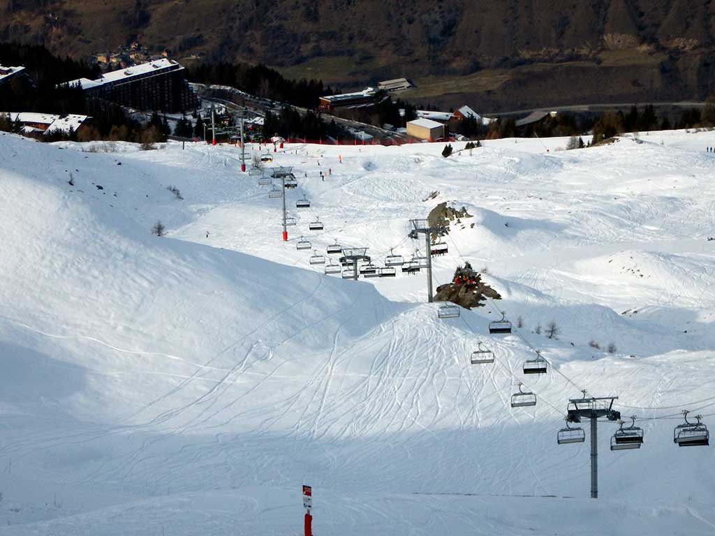
It's a similar story in the 1600/1800 valley, with snow thinning a bit on pistes below 1700m-ish, but still good skiing... Here's the top of the Arpette chair, and the view down toward 1600 showing the well-covered pistes... 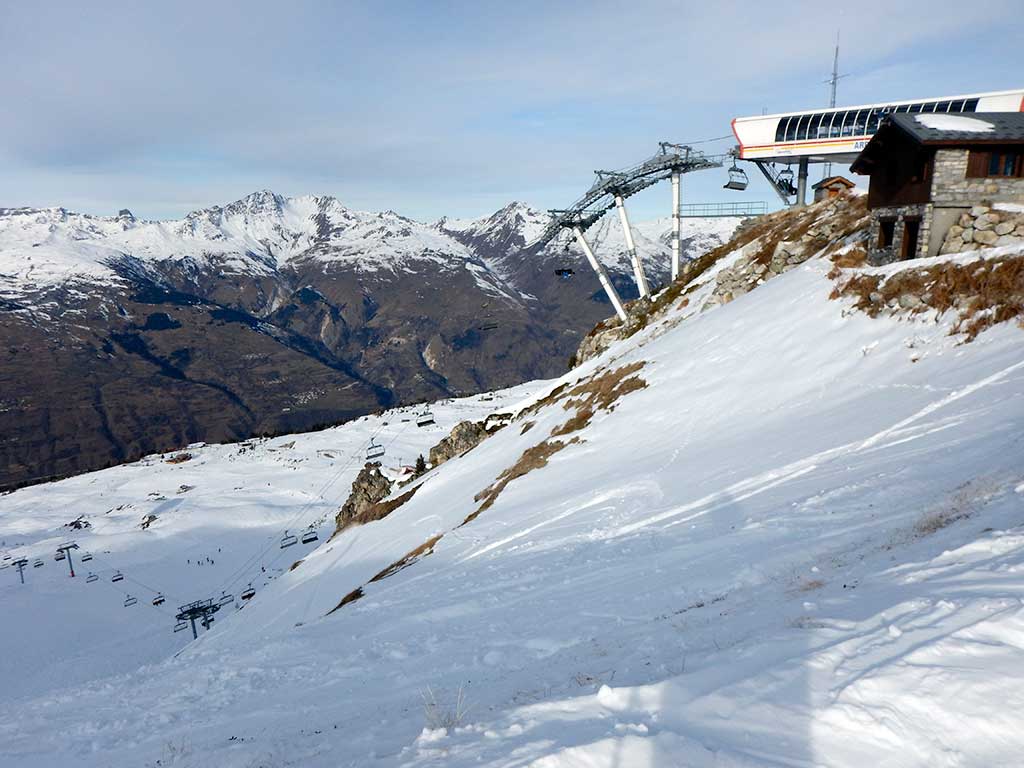
We obviously can't judge the lowest ski areas further South, but we hear of good snow conditions in Espace Killy and Three Valleys also. Will post further updates as the week develops - and we're still hopeful of a light top-up mid-week but we shall see... |
|
|
Have to agree with Gareth - you need to go high.
I'm in Les Arcs this week (see Les Arcs Snow Report); the snow on the pistes is actually pretty good from 1800m upward but if you're looking lower than that then you'll need North-facing slopes... It'll be interesting to see how the conditions develop but there's good skiing at altitude. |
|
|
This winter, we're kicking off our season in the familiar surrounds of Les Arcs; we say familiar but it's been a few years so it'll be interesting to see what's changed...
Having previously stayed in pretty much every "Arc" village from Villaroger to Peisey, a recent presentation from Arc 1950 persuaded us to try the most recently built of the Les Arcs stations. Cheap flights from easyJet and the promise of quiet slopes in the opening week sealed the deal and here we are. We stopped over in Bourg Saint Maurice last night, and were treated to a classic temperature inversion; scraping the ice off the car in Bourg at -6C and then climbing up the Les Arcs road with temperatures rising to about 3C at 1500m, before they began to vary markedly between sun and shade (we'll come back to this below - because it matters for the snow). So, about that snow... As was clear as soon as we got to Pre St Esprit (the lowest point of the Arc 1950/2000 valley), there is, actually, no problem with piste cover at this altitude and above. We dropped straight down from 1950 for our first run of the season to warm up the ski legs and found good snow - "packed powder" - all the way down. This part of the mountain gets limited sun at this time of year and that's obviously helping. Higher up, the pistes are in good condition with every variation of the aforementioned "packed powder" - some patches of sugary cannon contributions but generally a firm base under a "chalky" surface. There are areas of hard pack, on slopes with more sun exposure but those are limited. The lower pistes, probably from 2100m down, hardened up notably as the sun left the valley around 3pm and the air temperature dropped rapidly. Where the snow is lacking is off piste. Some of the highest "between the piste" areas look tempting but much of it also looks quite sketchy with thin cover and plenty of rocks apparent that you'd want to be well buried. Unless you're very confident of your line, and know the underlying ground well, we'd really advise to stay on the marked runs until more snow comes. Les Arcs - phased opening Somewhere around half the ski area opened today (first day of the season), with notable exceptions including the runs down to Villaroger which remain closed. The resort plans on gradually opening up more runs as the week progresses and we'll report on that as we do. We stayed in the 2000 valley today, but will head over the ridge to 1600 and 1800 tomorrow to see how conditions compare. More pictures to come tomorrow, but this view of Mont Blanc from the top of the 2000 valley gives a good overview to start with... 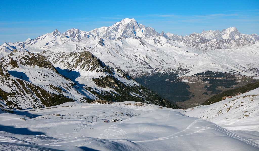
You can make out La Rosiere half way down the right half of the picture; and it's clear the snow is thinner on slopes exposed to more sun. There are deals still to be had for Xmas week, but we doubt they'll last long as people previously looking at lower resorts switch their attention to those like Arc 1950 that have the height to keep the snow. [Disclosure - Arc1950 Tourist Office are kindly supporting our trip, although our opinions are our own!] We'll post plenty more updates on the conditions, and lift openings, through the week. |
|
|
J2Ski Snow Report - December 10th 2015
The Snow This Week - Turning more wintery in the Alps after another dry, sunny week. - Over two feet of snow in the last week at Whistler. - Some larger resorts now have more than 100km of terrain open, including St Anton. It has been a quiet week for fresh snow on the world's ski slopes. The focus has been particularly on the Alps, Dolomites and Pyrenees for most European skiers with an unusual picture to report. Essentially, on the piste, conditions are generally good. This is despite a lack of fresh snow so far in December but following the snowy end to November. It has been very warm, too warm in fact, with the freezing point rising above most Alpine peaks but if you've been out on the snow this last week, you've probably enjoyed beautiful conditions. But those who love powder, or who have holidays booked when the main season begins, may be feeling nervous about the warmth and the lack of fresh snow. The good news then is that this seems to be changing now, with unsettled weather and light snow expected over the next 72 hours (resorts in the Western Alps have already reported a few inches of snow in the last 24 hours) plus the freezing level dropping. Then, hopefully, snow next week, in perfect time for Christmas week. Well, that's the theory. In the meantime resorts are continuing to open, thanks largely to snowmaking on lower slopes. Elsewhere there are similar conditions in Scandinavia, with limited openings to date but conditions becoming more wintery over the coming week. In Scotland warm weather has impacted the snowpack and in North America the East/West divide has continued with the Western side of the continent once again reporting the biggest snowfalls of the last seven days. In The Forecast Alpine temperatures remain a little milder than average at the moment, but should decline as we move into next week. A change in the weather, to more unsettled conditions (with precipitation!) has been a consistent feature of the forecasts for the past few days and looks likely for the middle of next week. The latest forecast indicates a couple of days of light to moderate (heavy in places) snowfall with a snow line anywhere from 1500m to 2000m depending on location. Beyond next week, the forecasts are all over the place to be honest... but definitely worth watching as the new weather pattern rolls in. The Alps Austria The number of ski areas open in Austria increased dramatically at the weekend and around 100 of the country's centres are now open. That's despite challenging conditions in terms of warm temperatures and limited snow cover on lower runs. The vast majority of centres have only limited terrain open at this early stage in the season whilst prepping more to open once the crowds arrive for Christmas week. Snow depths are typically in the 20-40cm bracket at most areas. Some of the glacier centres and other early openers have much more to ski now however. Solden has almost 100km of runs open (97km to be precise) and more than four feet (129cm to be precise) of snow lying on upper runs for example. St Anton has 108km open and nearly 50 lifts operating and is getting very favourable online reviews from lucky early-season skiers for its current conditions. France More than 50 French resorts are now open and others are due to join them this coming weekend, including one of the world's biggest, La Plagne, whilst Chamonix will fully open all of its areas. It currently reports the deepest snow in the country on upper runs with 1.5m (five feet) of snow. The number is 15cm/6 inches down in the valley. Conditions have been dry, sunny and warm in common with most of mainland Europe, but that has meant great on-piste conditions with seemingly not too much damage done to the snow pack and things now becoming more wintery. Generally, again as with the rest of the Alps, the higher you go the better conditions are, which is good news for France due to its large number of high altitude ski areas. Tignes and Val Thorens both look good with 60-80cm base depths and lots of terrain open. Italy Italy remains something of a nation divided with virtually no fresh snow over the past week so – as it has been for the past few weeks – the western side of the country continues to have the better natural snow conditions having had the lion's share of the November snow, whilst the eastern side and the dolomites continue to rely on machine made snow, mostly, in order to operate. This hasn't proved much of a problem it seems with the full Dolomiti Superski region opening hundreds of kilometres of slopes last weekend. Cervinia has the deepest snow with a 125cm base, and fresh snow is expected there – probably about a foot in the next week. Switzerland It's a similar story to the other 'big 4' Alpine nations for Switzerland but here most areas have reported an inch or two of fresh snow in the last 24 hours and most expect another 20-40cm by this time next week, good news just coming up to Christmas. About three-quarters of Swiss centres are now open with the deepest snow (1.2-1.5m/4-5 feet) at Saas Fee, Zermatt , Andermatt and Engelberg. That's up on higher slopes, down in the valley depths are a less impressive 0-30cm in most cases, not helped by the recent warm week. Hopefully this latest snowy spell will make the arrival of winter proper. Scandinavia In Scandinavia it has remained warmer than most areas would like and it has been difficult for many to open as much terrain as they'd hope. However as with the Alps to the south there's been some snowfall and temperatures have been getting cooler so snowmaking systems have been at full blast and most of the top resorts such as Hemsedal expect to be almost fully open from this weekend. Full winter conditions are also expected to kick in in the next few days too. Pyrenees Snow depths are holding up in the Pyrenees so far although there's been no fresh snow this month and no more is expected now until after Christmas at most areas. However depths of 40-80cm are still in place from the healthy falls in late November here too and snowmaking systems are topping up whenever temperatures allow. Eastern Europe The snow looks reasonably good on the web cams but few Eastern European resorts are posting snow depth reports so far as they're not generally open yet. However some of the Bulgarian areas are saying 20-40cm with a mix of machine-made and natural snow. Scotland It has been another week of up and down weather conditions in Scotland, as is the norm for the UK. Warmer temperatures have impacted snow cover but there's still plenty of the white stuff on most slopes so a return to colder weather could still mean a pre-Christmas opening. North America Canada Yet another snowy week in Western Canada with Revelstoke and Whistler scoring another two foot/60cm of fresh powder. Revelstoke currently leads the country for snow depth with 1.6m lying after clocking up nearly 5m of fallen snow already this autumn alone! Other resorts in Alberta and B added 20-50cm in most cases too. Sadly the east is still struggling with little or no fresh snow and snow depths pitifully thin with mostly or entirely machine made snow. USA More healthy snowfalls in the Western Us if not quite on the scale of November with most areas reporting 10-40cm of fresh snow over the last seven days. Timberline in Oregon was one of the bigger winners with 40cm of fresh, hopefully helping to set it up for summer skiing next spring and summer. Mammoth also did well and has the country's deepest base at present with 1.2m (4 feet) of snow lying. Bigger snowfalls are expected in the next seven days with up to 1.5m expected at some resorts. On the East Coast it's a similar picture to Canada to the north, although with some natural snow. But most is machine made at present. |
|
Mountains, Candide... but no snow? Surely some mistake...
Started by User in Ski Chatter, 13 Replies |
|
|
Looking a lot better than this time last year for the French Alps from what I can see; a bit of a top up going on this morning (only a few cms but enough to freshen the surfaces). We'll be in Les Arcs next week; we won't be in deep (although mid-week should see a further fall), but pistes are looking good.
|
|