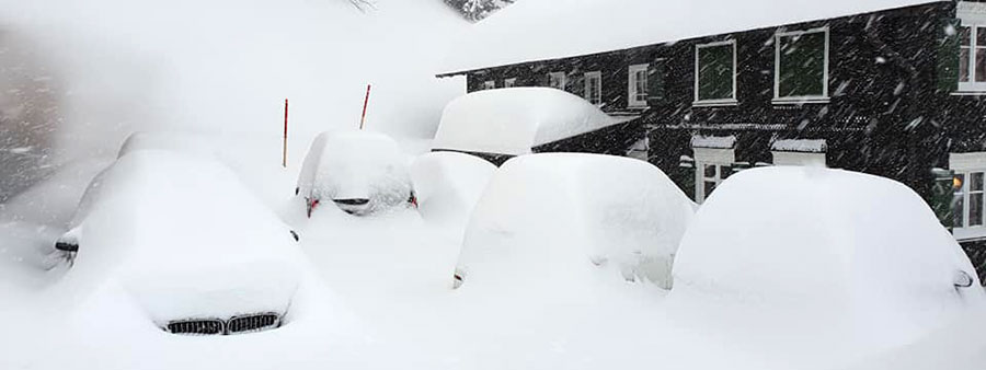
Dude, where's my car? Lech, Austria, yesterday...
Every sort of weather this week, more snow on the way!
The Snow Headlines - 6th February
- Good snowfalls in the Alps again after a warm, wet weekend.
- World's deepest base passes 5-metre mark for first time this year.
- Europe's deepest base climbs back above 4 metres.
- Weekend rain in Alps and Pacific Northwest affects snow cover for a time.
The Alps have had another heavy snowfall which, combined with last week, has brought quite a few high altitude areas more than a metre of snowfall in the past 8-10 days, and one Swiss centre more than two metres.
The result of that is that base depths are finally growing again back above the 4-metre mark in the Alps that they stalled at just before Christmas and the start of "dry January" (which had a different meaning to the common one when it came to most of Western Europe).
The news is not all good; the weekend saw warm temperatures in Western Europe and the freezing point reaching above the mountain tops so many areas had rain, spoiling the fresh snow from a few days before. For some lower elevation areas that rain has washed away thin cover, but that's not the case for most of the major destination resorts which had decent bases from the big snowstorms of this winter, and thankfully now have more fresh cover.
In terms of avalanche danger though, the snowfalls, temperature fluctuations, periods of rain and gale-force winds have left off-piste cover unstable and the Avalanche Risk Level is still widely 3-4 (of 5 - Considerable to High).
Take care if thinking of heading off-piste!
Elsewhere, there's been snow for Eastern Europe too but it has been dry and a bit too warm in the Pyrenees. Scandinavia has had more snow (notwithstanding the fact that overall it has been a much warmer than average winter here too). In Scotland, the cycle of storms/thaw continues with currently calm weather and some runs re-opening on the West.
Across the Atlantic, there was weekend rain too for the Pacific Northwest but snow since and one ski area in Oregon is the first in the world this winter to break the five-metre snow depth mark. Elsewhere many areas have seen low temperatures and some fresh snow across Canada and the US.
In the Alpine Forecast
Clear and mild this weekend, after which another substantial snowfall is building in the forecasts for early next week; details very much TBWGA (to be wildly guessed at!) at this stage, but Monday through Wednesday looking to be very snowy in the northern Alps and possibly beyond!

What's that coming, over the hill? watch this space...
Re-publication :- our Snow Report Summary, being the text above this line, is free to re-publish, but must be clearly credited to www.J2ski.com with text including "J2Ski Snow Report" linked to this page - thank you.
EUROPEAN ALPS
Austria
It's a snowy picture across Austria after a wet weekend with resorts across the country excitedly posting pictures and video of heavy snowfall down to resort level. In fact, Austrian areas have posted some of the biggest and best numbers for accumulations over the past three days, and some of the earliest powder alarms back on Monday.
Galtur, near Ischgl, and Bad Gastein both posted 40cm falls in 24 hours to Wednesday and over the last 72 hours, Loser has had 60cm (two feet) of snow.
The snow will continue for many through Thursday after which a period of clear weather is expected to start the weekend, with above-freezing temps again, although this time hopefully only a degree or two above zero, before more snow arrives around Tuesday next week, according to the current forecast.
France
Some great snowfalls in the French Alps over the past 48 hours with 20-50cm of fresh for many areas. La Plagne, La Rosiere, Les Arcs, Chatel and Flaine amongst those posting the bigger accumulations but good falls almost everywhere.
The snow did arrive after first rain, then strong wind caused issues at the start of the week, however, which are a few days to forget for many French areas, but hopefully, now we're due sunnier, fresh snow days before the next lot of snow clouds arrive next week.
Italy
Italy's snowfall over the past few days has, as forecast, been heaviest along the country's north and west, but there was a little (largely not forecast!) snow in the Dolomites too – at least Arabba has reported 8cm (three inches) of fresh since Monday.
The biggest fall though (20cm) was at Cervinia, but most of the active snow-bearing weather front passed along Italy's northern border. Now ski areas that weren't left in the sunshine are back in it as the front has moved off East.
The week ahead looks like a sunny one and mild (+2C to +8C) at more southerly Italian centres. Things should change early next week with a snow-bearing front expected to move in from Tuesday.
Switzerland
Swiss resorts have been posting the biggest snowfall totals of this week and from last week's storms.
In fact, the Lotschental region briefly reported it had a 7 day total of 2 metres of fresh snow by adding together the two big dumps it received!
Like most resorts in the Alps, the country's snow cover was affected by warm weather and rain at the weekend, although some high centres, including Zermatt, reported a foot of snowfall when others were getting rain, although they didn't specify if that was just up on the glacier.
For the latest storms, which are just winding down, the last stats we got on Wednesday afternoon showed Belalp and Lotschenal posting 70cm+ snowfalls this week, Zermatt 45cm.
Here too sunny weather is forecast now through to early next week with temperatures hovering around zero before the next snow arrives Monday/Tuesday.
Scandinavia
A second Norwegian ski area is posting a two-metre base after another week of regular snowfall. Roldal has joined Voss Myrkdalen in publishing this deepest-of-deep-snow stats by Scandinavian standards.
Meanwhile, in northern Sweden, where Riksgransen ski area opens for its spring skiing season at the end of this month, they're reporting the pre-season snow depth is the best this century there – showing the contrast between the relatively good conditions in the north and record warm temperatures in the south of the region this winter.
Pyrenees
Despite all the weather drama happening a little to the east in the Alps, things have been fairly calm in the Pyrenees, the main weather factors being sunshine and occasional strong winds that did close quite a few lifts and the runs they serve in Andorra mid-week for a time.
Spring-like weather has led to some thawing but most areas have good bases so can survive this and still stay fully open for the time being. Fortunately, the forecast is also for cooler temperatures now.
Scotland
Another week that has seen Scottish ski centres battling to open more terrain as the elements try to prevent them. After the thaw a week or so ago now temperatures on the hills have stayed at or below freezing most of the time and there has been some snow build-up, again in the West, as has been the case in recent weeks.
Nevis Range say they don't have enough yet to re-open but Glencoe had managed to create a few complete runs by Wednesday – only for lifts to be closed by strong winds. Hopefully, they'll be open later this week. For most though it's just the small beginner areas created with all-weather snow-making machines again.
Eastern Europe
It's been the snowiest few days of the year so far over the past 48 hours in many parts of eastern Europe. Slovakian ski areas have posted some of the biggest snowfalls anywhere in the world in the past 72 hours with many of the country's bigger resorts reporting 60cm (two-foot) accumulations on higher slopes.
There's been snowfall down in Bulgaria too, which has had very little so far this season. The numbers were not in at the time of completing this report and the snow was still falling but posted images appeared to show at least 30cm of fresh cover.
North America
Canada
More snowfalls in western Canada and again the heaviest on the pacific coast of BC. Whistler has reported another 50cm of snow over the past week with rain on lower slopes, but it has 99% of its terrain, North America's biggest, open now.
Inland, smaller falls have refreshed cover at resorts like Revelstoke, Big White and Lake Louise. Eastern Canada has had more fresh snow, but it's still far from a normal season with some of the best conditions currently down in the eastern townships of Quebec on the US border where Mont Sutton reports it finally has every trail open after a little more fresh snow there.
USA
More big snowfalls for the northwest USA after a rainy weekend, with Mount Hood Meadows in Oregon, suddenly increasing is claimed upper slope base depth by several metres (compared to a week ago) to nearly 5.7 metres – making it the first in the world to claim more than a five-metre depth this season.
Alpental in Washington State, reporting another 60cm (two feet) in the past 72 hours, is in US/world second place on 442cm.
Across the rest of the country, the picture remains pretty good, except in southern states. Ski areas in Colorado and Utah have healthy base depths and are reporting up to 45cm of fresh snow since Monday. There's less fresh in the east but after recent weeks of good snowfalls, things are generally looking much better than they were here too with almost everything open.
An interesting week coming up... thanks for reading...