
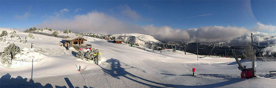
Looks like another fine day in Les Angles, French Pyrenees...
Snow all over, sunny for some, and more snow on the way...
This Week's Snow Headlines - 7th March 2019
- Fresh snow after 3-4 dry weeks in the Alps, Dolomites and Pyrenees.
- More heavy snow in the USA as Colorado gets up to 1.2m (4 feet) of new snow.
- March snow turns Scottish hills white again..
There's been a big change in the weather in the Alps (and indeed the Dolomites, and now the Pyrenees) after a warm and dry period that took up the last three weeks of February. It has turned colder for most places, the snowfall has returned, and all-in-all, now that (meteorological) spring is here, it has started to feel a lot more like winter than it did.
It is a mixed picture, some ski areas in the Alps have now had more than 60cm (two feet) of snow over the past week, whilst others haven't had much, and the colder weather is only just arriving in the Pyrenees, but it does look set in for the week ahead in many areas with some parts of Switzerland currently forecast to get more than another metre of snowfall by this time next week.
The version of winter we're getting in March isn't completely benign as the March wind has been blowing pretty hard at times, shutting more exposed higher lifts and runs on occasion.
Elsewhere in Europe, it is staying snowy in much of Scandinavia and the snow has returned to Scotland after the record February UK temperatures, with areas optimistic that they'll soon have enough to start re-opening slopes.
Over in North America, there have been more big snowfalls and low temperatures in the US. This week Colorado ski areas have topped the snowfall tables rather than California, but it has still been snowing there too, and over most of the rest of the country.
In the Alpine Forecast
Varying temperatures, but generally below or around seasonal averages, look to be the pattern for the next week or so... with a lot of snow mixed in. From today's forecasts, parts of Austria and Italy should get some good snow over the next few days, with the northern / western Alps (France and Switzerland) setting up nicely for some big snowfalls after a generally clear weekend.
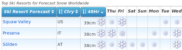
See where it's expected to snow this week...
Re-publication :- our Snow Report Summary, being the text above this line, is free to re-publish, but must be clearly credited to www.J2ski.com with text including "J2Ski Snow Report" linked to this page - thank you.
EUROPEAN ALPS
Austria
Parts of Austria did have some snow early last week before the three week warm/dry spell ended everywhere else, and resorts like Saalbach in Salzburgerland are getting more snow now; with plenty more forecast for the week ahead – 20cm in Saalbach's case.
But it is a mixed picture with some Austrian resorts only forecast to receive 10cm or so, others, including parts of the Arlberg and the Otztal Valley, as much as 50cm. Five of the seven deepest snow depths in the country are all on the glaciers and all amounting to four metres or more on upper runs.
France
French slopes saw some of the best new snowfalls at the end of last week with the Portes du Soleil, Paradiski and Grand Massif regions looking especially snowy and reporting 10-25cm of fresh snow.
Cauterets, down in the French Pyrenees, is still reporting the deepest snow in the country at 3.2 metres, but that's down 80cm on a few weeks ago after the warm weather, although more snow is reported to be on the way here too.
The week ahead looks snowy in France too with almost everywhere showing as likely to get at least a little snow almost every day for the next seven days. The only question seems to be, "how much?" and here the amounts vary from maybe 30cm in total almost everywhere to potentially 80cm in a few areas like La Grave and the Chamonix Valley.
Italy
There's snow at last for Italy too where most ski areas haven't seen any fresh for rather longer than resorts in Austria, France and Switzerland to the north. But so far there's been up to 20cm reported in the Aosta Valley and smaller falls further East in Lombardy and into the Dolomites, where the snow has arrived more recently. In fact, accumulations across the Dolomites over the next 48 hours should be 30-40cm before skies clear again for the weekend.
In the Italian Alps to the West though the snow is expected to continue falling through the weekend adding up to 40-60cm accumulations by the start of next week. Passo Tonale still has the country's deepest base, reported at 4 metres.
Switzerland
Swiss ski areas have seen some of the biggest snowfalls since the weekend with Lötschental reporting the biggest accumulation so far with 58cm (almost two feet) of fresh snow.
There have been good snowfalls across the country including at Andermatt, which has been posting the deepest snow in the world at 6 metres (20 feet) for most of this season and is one of those currently forecast to receive more than a metre more snow over the coming week. So will that 6-metre figure finally increase?
Ski areas in the Valais in the west of the country have reported some of the biggest accumulations so far (20-50cm on average) but there has been snowfall almost everywhere and the week ahead is looking snowier still with almost everywhere expecting 30cm and some areas like Andermatt potentially more than a metre of snow.
Scandinavia
It's been snowing in Scandinavia fairly consistently over the past week following the mixed February conditions. The exception is Finland where it has stayed cold at least but there's not been much fresh snow to talk of.
The biggest accumulations in recent days have instead been around Norway's coast, where up to 20cm of new snow has been reported since Monday. So there's powder condition in the west and smaller falls giving fresh cover on most of the rest of Norway and Sweden's ski slopes.
Pyrenees
Great relief in Andorra as, after a full month of often warm, dry weather, it is snowing once again in the Pyrenees.
The fresh snow is well timed for the upcoming World Cup finals in Soldeu, so long as the weather clears in time for the races. In the meantime, it's very much business as usual with ski areas reporting decent basses still and more or less all runs open and all lifts operating across the region.
Scotland
It's an improving picture in Scotland too with snow on the hills again after the three-week February thaw, which was an extra bad one after Britain enjoyed record warm temperatures for the month.
But there's now fresh cover across all five highland areas after the Western centres of Glencoe and Nevis Range got the most at the weekend. It's a little soon for them to re-open but the snow is still falling and currently expected to continue through the week ahead with the 20-50cm forecast, so hopefully, by this time next week, it will be a much-improved picture. As it is, for now, there are just the small beginner areas open at Cairngorm, The Lecht and Glencoe thanks to all-weather snow-making machines.
Eastern Europe
After the snowfall a week ago things have been generally settled and mostly dry on Bulgarian ski slopes over the past week. There's no real sign of change on the horizon there, perhaps a little light snowfall, particularly in Borovets, but generally, if anything, temperatures are rising at times well above freezing making a thaw more likely than fresh snowfall most of the time. But for now bases remain good and virtually all runs open.
North America
Canada
Mont Tremblant in Quebec's base continues to grow, seemingly faster than they report snowfall, and is now up at 496cm on upper runs, tantalisingly close to the 5-metre mark and just a few feet below North America's deepest at present in California over on the continent's opposite coast.
There has been some fresh snow in Quebec in recent days – just not too much – 5-15cm more widely reported. It's a similar picture for the week ahead although bigger falls are now being forecast for Alberta and BC with a 20-50cm forecast for ski areas including Big White, Sun Peaks and Whistler.
USA
After last month left California '#FebruBURIED' the focus this week has switched somewhat to Colorado where half a dozen ski areas including Aspen and Copper Mountain have now reported more than a metre of snowfall in the past 7 days. Breckenridge has posted the biggest total at 1.2 metres (four feet).
But it has not just been Colorado, much of the US is battling with snowfall of the kind that goes beyond joy for skiers to misery for travellers with thousands of flights cancelled and a state of emergency declared in New Jersey at the start of the week, plus record March cold in the Midwest.
And it is still dumping in California – just not quite so much as last week, or as in Colorado. But, in brief, there's some-to-a lot of fresh snow on almost every US ski slope.
Until next week...