
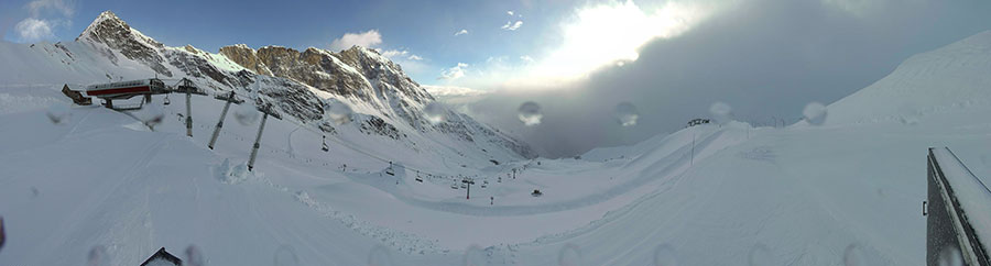
A bit of sun, and a bit of snow for Cauterets today...
J2Ski Snow Report 15th March 2018
Winter continues into Spring!
This Week's Snow Headlines
- Snowy end to the week expected in the Alps and Dolomites.
- A third March snow storm hits North America's East Coast.
- Engelberg reclaims current-deepest-snow-base-in-world title (655cm) from Mt Baker in US (610cm).
- Heavy snow again in California (March snowfall is as much as the rest of season put together).
- Biggest snowfall in Europe of next 48 hours may be at the continent's most southerly major resort, Sierra Nevada in Spain, where 60cm+ is forecast.
Considering the start of astronomical spring is fast approaching next week (and meteorological spring has already clocked up its first fortnight), it's still looking fairly snowy on both sides of the Atlantic, and in many cases snow depths are still getting deeper, even at resorts which officially only have a month of the season left.
It's not all snow though, it has been getting gradually warmer over all and some resorts did report rain at lower elevations this week whilst the snow deepened up top. But March looks set to continue snowy in many areas for at least the coming week with 30-50cm of snow forecast by the weekend for many resorts.
Across the Atlantic it has been snowing too on both East and West coasts again. The East seems to have been taken particularly by surprise with three successive snow storms transforming conditions there after an often too-warm February. On the West there have been more huge snowfalls, including 20-50cm overnight at many resorts around Tahoe yesterday, as the March deluge continues.
In the Alpine Forecast
This coming weekend will see colder weather return across much of The Alps, The Dolomites and The Pyrenees, with precipitation coming in as snow to quite low levels for March - as low as 1,000 metres in many areas.
Temperatures look like remaining below the seasonal average for at least the next week, and perhaps beyond.
Avalanche and Off-Piste Risk
Widely varying temperatures, and abundant snow, means the avalanche risk remains extremely complex; so always take local advice before leaving marked runs; have fun but stay safe!
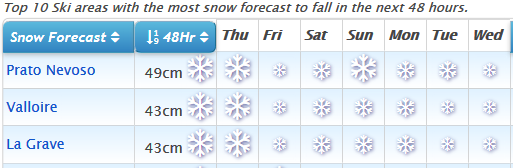
See where it's expected to snow this week...
Re-publication :- our Snow Report Summary, being the text above this line, is free to re-publish, but must be clearly credited to www.J2ski.com with text including "J2Ski Snow Report" linked to this page - thank you.
EUROPEAN ALPS
Austria
A mixture of sunshine and cloud for most of the past week on Austrian ski slopes with little fresh snow and therefore little change to base depths. If anything, there's been some thawing at lower elevations as temperatures have crept above zero at times. There was some snowfall at the start of this week, the biggest measured 20cm in 24 hours to Wednesday in the Silvretta region but more commonly 5-10cm to freshen up the slopes.
The deepest snow (up to 595cm/20 feet at Kauneral) continues to be on the glaciers but the snow pack remains healthy across Austria, particularly on higher slopes. More fresh snowfall is expected for the latter half of this week but in most cases forecasters are just expecting another 5-10cm, nothing huge.
France
It's been a fairly snowy week in France with resorts reporting up to 30cm of fresh snow in 24 hours and snowfalls also from northern to southern French Alps. It's looking like it will stay snowy too with forecasts of another 20-40cm of snow by the end of the week.
It's not all good news though, on the one hand Chamonix reported nearly a foot of fresh snow on Tuesday morning, on the other it reported rain falling below 1800m. It's had 50cm of snow in the past week, the 4th most in Europe and second in France behind La Grave with 70cm. So to sum up – it's been snowy at times and it's going to stay snowy at times. Base depths remain remarkable with spring less than a week away – Avoriaz reached a total of 4m on its upper runs, 2m on its lower runs this week.
Italy
Italy's north-western Alps have seen the most snow again of the past week as the prevalent weather system seems to be favouring the southern Alps for the biggest snowfalls. Resorts in the Piemonte region have reported up to 40cm of snowfall in the last 72 hours and, a little to the north, Cervinia's base in now 230-400cm after another 20cm of snowfall in the past few days, so it's looking good for its spring skiing season in to May.
The week ahead is looking quite snowy in Italy too with 30-50cm for many ski areas in the country forecast by Saturday. Around a foot of snow is forecast for the Milky Way region on the French border for example, with 35cdm expected at San Martino in the western Dolomites.
Switzerland
It has been an often snowy week in Switzerland over the past seven days too and here also more snow is forecast in the run up to the weekend. Engelberg has had 220cm of fresh snow in the last few days and says its upper slope base is back up to 655cm (22 feet) moving back above Mt Baker over on the US Pacific Coast.
There's still two months of the season to run there. Elsewhere it's a picture of deep snow on upper slopes across Switzerland (504cm at Andermatt) but thawing cover on lower runs as you'd expect in spring. Many still have a metre or more lying even on lower runs but Grindelwald, for example, says it has 0cm at resort level.
Eastern Europe
Mixed weather the past week in Eastern Europe with some snow, snow rain, some cloud and some sunshine. Slopes in Bulgaria are still holding a fairly good base however and all of the country's centres report they're pretty much fully open. Bansko has the deepest base in the country at 100 – 270cm and 17 of its 18 runs are open with all but one of its lifts operational. All report bases of 50-60cm.
Scotland
Still good conditions in Scotland even though temperatures have risen a degree or two above freezing. All five Highland centres remain pretty well fully open – from Glencoe, with 100% of its slopes open still, to the Lecht with 10 of its 22 runs to ski. It's due to turn colder from the weekend again but there's not much snow in the forecast.
Pyrenees
The Pyrenees, like the alps, have been seeing a mix of sunshine and snow. Bases here are good too – up around the 2m mark, with all runs open and all lifts operating, pretty much, so it's currently looking good for Easter and beyond. Europe's most southerly major ski area, Sierra Nevada in Spain, may get the continent's biggest snowfall by the weekend with more than 60cm (two feet) forecast.
Scandinavia
Not much change in the Scandinavian ski nations over the past week – only that the hours of daylight are rapidly getting longer and from next week's equinox on will quickly outstrip the alps. Snowfall of 5 – 10cm has been reported at ski areas across the region, with Kvitfjell in Eastern Norway reporting one of the bigger accumulations, but resorts in the west of the country still have the bigger base depth totals at up to 3.8m.
North America
Canada
Some of the biggest snowfalls in Canada this past week have been on the East Coast and in the past 48 hours as the latest storm to hit the east Coast has brought 30-40cm 24 hour accumulations to many areas in Quebec, including Mont Ste Anne and Mont Sutton. The deepest snow remains on the west however where depths are over 4 metres (13 feet) at some BC coastal ski areas. Generally ski conditions remain good across most of Canada though, with most international destination resorts in the country running at capacity.
USA
It has been a second week of heavy March snowfall on the East and west Coasts of the USA. On the west it means that snowfall in March already is as much as the whole of the winter period, on the east it is more a case of a return to winter after a worryingly warm February saw snowpacks thaw dramatically.
East Coast snowfalls have been as much as 115cm (nearly four feet) in the past week at Wildcat Mountain in New Hampshire (including 60cm/2 feet in 24 hours on Tuesday/Wednesday this week). On the west bases are as deep as 6m (20 feet) at My Baker in Washington State and 30-50cm of fresh snow has been reported including 30cm (a foot) in the past 24 hours at resorts like Heavenly and Squaw Valley.
More snow is expected in the West including more in California and as far inland as Utah, over the next few days too.