
Mixed skies and fresh snow in Les Arcs this morning...
More snow in the forecast, after a lighter, sunnier Christmas week in Europe.
This Week's Snow Headlines
- Another week of snow forecast for Europe.
- Up to two feet (60cm) of fresh snow over Christmas in Colorado and Utah after dry December.
- Heavy snow in Norway on Boxing Day, with up to 48cm in 24 hours.
- Big snowfalls (up to 90cm in 48 hours) in New York State.
- Cold weather but little snow in Scotland as all-weather snowmakers start.
Europe has had a mostly dry Christmas holiday with the majority of slopes and lifts operating and skiers and boarders enjoying often-sunny slopes. The past 36 hours have seen a distinct change, however, and snow is falling again. This heralds the start of an unsettled week likely to bring a forecast 30-50cm of fresh snow, but also some strong winds and low visibility at times - as well as increased avalanche danger off piste.
Unusually, virtually all parts of Europe have snow falling including the Dolomites, Pyrenees, Scotland and Eastern Europe as well as the Alps.
Across the Atlantic there was Christmas joy in Colorado and Utah as the December dry spell ended for a few days at least and up to two feet (60cm) of much needed fresh snow fell. That's dramatically improved conditions in the worst hit areas.
In the Forecast
Widespread and, at times, heavy snow is forecast for many areas over the next week and beyond. The Eastern Alps and some parts of Italy could see some heavy falls today, with Western and Northern French Alps looking to be in the firing line for this coming Saturday.
Transfer Day Warning :- Heavy snow is likely to cause disruption this coming Saturday, particularly in the usual bottlenecks of the the Northern French and Swiss Alps, so plan accordingly!
Accumulations over the next seven days are likely to be anywhere from 20cm to 50cm across a wide area, with significantly more in a few locations.
AVALANCHE RISK
Heavy snow and winds, in progress and forecast, mean that avalanche risk will increase over the next week and may be very high in places.
Please exercise caution off-piste and take local advice!
Always check local conditions and resort opening times directly before travelling!
See when and where it's going to snow...
Re-publication :- our Snow Report Summary, being the text above this line, is free to re-publish, but must be clearly credited to www.J2ski.com with text including "J2Ski Snow Report" linked to this page - thank you.
EUROPEAN ALPS
Austria
Austrian ski centres had a largely clear and sunny Christmas in common with other Alpine nations. The snow has now arrived however, as have strong winds and poor visibility with it at times – the Stubai glacier delayed opening until 10am on Wednesday 27th December because of it. The snow is expected to come and go for much of the week ahead with up to 40cm expected at many areas by the weekend and then similar falls again into next week. Most Austrian resorts already have good bases thanks to earlier falls. The Dachstein and Kitzsteinhorn glaciers reporting the most with just over 3m (10 feet) lying on their upper runs.
France
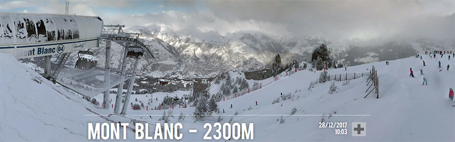
French resorts had a largely pleasant Christmas as snow clouds cleared by the middle of last week to give sunny skies over the weekend and at the start of this week. They almost invariably have excellent conditions on the groomed slopes thanks to all the pre-season and early season snow that has fallen. And now its back with the snow starting to fall on Tuesday evening and expected to be at its heaviest initially this Thursday 28th December with many resorts expecting around 30cm of snow.
Then a lull on Friday before more big falls, perhaps bigger than Thursday's this coming weekend. So the avalanche danger is likely to stay around 3-4 on the scale to 5 but hopefully there won't be any problems on transfer days. Resorts in the Grand Massif are currently posting the deepest bases at around 245cm but most of the other big French regions have around 2m lying on upper slopes now.
Italy
Italy has had a mostly dry and sunny Christmas also but the weather has begun changing here too with fresh snow arriving over Tuesday/Wednesday night and Aprica and Madesimo the first to post fresh snowfall totals of 35cm and 20cm respectively. By the end of Wednesday others had posted as much again or bigger still – 40cm for Pejo for example and 35cm again at Aprica. That's likely to be the start of a snowy end-of-the-week with 30-40cm of fresh snow forecast at most areas including the Dolomites as well as the Alps to the west. The deepest snow bases in Italy are around the 2m mark with Sella Nevea in the extreme east topping the table at 215cm and La Thuile in the extreme west in second place with 195cm.
Switzerland
Swiss resorts continue to post some of the deepest snow depths in Europe with Engelberg the only ski area in the country so far past the 4m mark at 4.3m snow depth up top. Glacier 3000 near Gstaad is next up with 2.5m. As with the other 'big 4' Alpine nations Switzerland saw a mostly dry Christmas with great conditions on the groomed runs and most of the country's runs open and lifts operating. Even ski areas that aren't posting the big numbers have perfectly decent bases of 50-100cm or better in most cases. And again as with the rest of Europe a snowy week awaits with plenty of snow expected in the next 24 hours and more again at the weekend and in to next week.
Eastern Europe
Conditions are very varied across eastern Europe with centres closer to the Central Alps seeming to do better with some big snowfalls (20-30cm) in the last few days in the Czech and Slovak republics and more snow forecast in the Polish Tatra mountains too. It's a less rosy picture in Bulgaria so far where resorts could do with some fresh snow. Bansko has a 5-40cm base and half of its 18 runs open but snow is forecast here too for the end of the week.
Scotland
It's a week since the latest big thaw wiped out snow cover in Scotland and the good news is that the thaw is over and its turned cold with fresh snow on Scottish slopes – there's just not been a lot of it and whilst temperatures as low as -15C are forecast before the next temperature rise at the weekend, there's not much snow expected. That said snowmaking guns, the few that there are, are operating and the two new all-weather snowmaking machines too with Cairngorm making snow for its nursery slopes.
Pyrenees
After a fairly dry week, conditions are looking much snowier in the Pyrenees. The region's largest area, Grandvalira in Andorra, is almost fully open with all 62 lifts operating and 109 of its 128 runs groomed and accessible too. Temperatures are dropping down towards double digits below zero. It's expecting 40cm of fresh snow by the end of Friday and similar amounts are expected at most ski areas in the Pyrenees.
Scandinavia
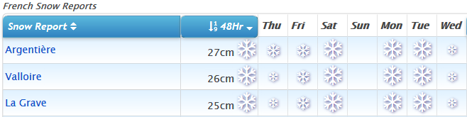
Scandinavia is having a period of heavy snowfall too with fresh snow reported across the region. Some of the big winners in the past few days include Trysil which got 48cm and Hafjell and Hovden which each reported over 30cm of fresh snow each on Boxing Day. Voss got 20cm and Beitostolen 25cm in the same period.
North America
Canada
Fresh snow in both East and West Canada this week as temperatures stay low but precipitation comes in. The temps in the range of -10C to -30C can be quite bracing (!) as usual in a Canadian mid-winter but they also keep the snow light and powdery. Blue Mountain in Ontario in the East has posted the biggest snowfall in the country with 33cm (13 inches) since Christmas, with Stoneham in Quebec clocking up 15cm in the same period, following a 24cm fall in 24 hours on Christmas Day and its neighbour, Le Massif. More snow is forecast in the West, including about a foot (30cm) of snow for Whistler over the next day or two.
USA
It has been a snowy week in the US with the ski states of Colorado and Utah seeing up to 60cm of snow fall over Christmas – particularly good news after a mostly warm dry November and December had left them struggling to open almost any terrain. They are still way behind schedule compared to an average season with in most cases less than half of their terrain able to open, but it's certainly an improvement. In the East there's been more big snowfalls for Christmas too with some record breaking snowfalls of over 1.2m in Pennsylvania and big snowfalls too in the Great Lakes region. Some of the biggest snow dumps of the last 72 hours in the US are from less well known destinations; whilst Jackson Hole has had 36cm of fresh snow for example, Kissing Bridge in New York State has had 86cm – just under three feet, and Boyne Mountain in Michigan 61cm (just over two feet).