Hello,
There's more snow to report, in more places, for Europe - and some huge falls in America.

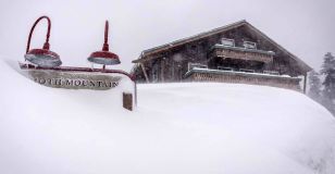
Mammoth Mountain, USA, really is getting buried... picture courtesy of Mammoth
This Week's Snow Headlines
- The Zugspitze Glacier at Garmisch in Germany has had 2m of snow this week - most in Europe.
- Mammoth Mountain base depth passes 5m after more huge snowfalls.
- Big snowfalls in the Pyrenees - up to 60cm so far, more forecast.
- Huge snow falls in Colorado, Winter Park gets nearly 2m of snow in one week.
- Much more snow forecast in Europe and North America.
2017 has continued in to its second week as it did the first, with snow, snow, snow and thankfully it's spreading, with a major snowstorm pushing into The Northern Alps tomorrow.
In the week since our last report there have been the most phenomenal snowfalls yet in California (where we are hearing of some road and resort closures due to avalanche risk - so check before traveling).
The Eastern European Alps have been dumped on also, with some parts of Austria and Germany receiving more than 1.5m/5 feet of powder, and lighter snows extending to the West.
But until Tuesday this week that snow didn't really make it past a line running through central Switzerland, with lots of snow to the East, little or nothing in France and Western Switzerland to the West. The good news is that has now changed with snow falling in the Western Alps too, and there are also big snowfalls underway in the Pyrenees. It's even snowing a bit, at last, in Scotland.
In the Forecast
A significant snow-bearing weather system (yeah, ok, a snowstorm) will push into The Alps from the North, starting later today (Thursday). The North and East (including Austria, most of Switzerland and the Northern French Alps) will see the snow fall heaviest and for longest, with light falls today and moderate further falls into the weekend.
In all areas, we currently expect the main event to be Friday. Accumulations of 20cm+ will be widespread across much of the Alpine area, with as much as 50cm over 3 or 4 days locally.
Once the snow passes (at the weekend), temperatures will drop significantly and the next week is going to be very cold in The Alps - so the fresh snow is going to stay in great form if you're lucky enough to be out there!
A word of caution!
Avalanche risk levels will be high in places. Check local advice and risks before leaving the piste and make conservative route choices! Piste conditions will be great anyway, so have fun and stay safe...
Re-publication :- our Snow Report Summary, being the text above this line, is free to re-publish, but must be clearly credited to www.J2ski.com with text including "J2Ski Snow Report" linked to this page - thank you.
The Alps
Austria
Austria has seen the biggest snowfalls of the big four Alpine ski nations, with some areas including Saalbach and the Kitzsteinhorn glacier above Kaprun reporting more than 1.5m (Five feet) of fresh snow up to last weekend. Snowfall has now eased off to 5-10cm a day at some areas but most Austrian resorts are definitely in the best shape they've been all season so far. Mayrhofen for example, which had been struggling for snow cover up to the start of 2017, now has 1.2m on upper runs and a foot of snow in resort. The good news is that more snowfall is forecast in Austria for the week ahead which could see as much snow again falling by this time next week, all being well.
France
After a bit of a false start a week ago it looks like some proper snow has finally arrived in France, and it's falling across the country rather than in just a part of it – even the Pyrenees are seeing snow, in fact probably more than the Alps. The snow started falling on Tuesday morning and is expected to continue at least until the weekend, by which time most areas should have had 30-40cm of snow, hopefully transforming conditions just as mainstream media were gleefully reporting that parts of France were going to limit snowmaking due to drought conditions (of course this is just in a few areas but the reports gave the initial impression it's the whole Alps). The new snow comes after the snow in the latter half of last week failed to deliver any significant snowfall to French slopes, the biggest snowfalls only 10-15cm and many areas getting just a few flakes.
Italy
Sadly Italy – in the Dolomites at least, continues to lose out with no fresh snow and as there hasn't really been any snow here since November it's an ongoing snowmaking effort to keep the slopes open, with green hillsides either side, pretty dire for January. Fortunately Dolomiti Superski and others are experts at this after a few similar seasons so most runs are actually open, but snow cover is as low as 10cm and never really more than 40cm. There may be some snow in the coming week but there's not a lot in the forecast. Rather ironically there's been much more snow in the south down the Apennines where some small ski areas have seen very big snowfalls. In the Alps to the West things look much better with 1-2m at most resorts there and some fresh snow.
Switzerland
A somewhat mixed picture in Switzerland – more than half of the country's leading ski areas have received between 30 and 50cm of snow in the last week, with more falling now and similar amounts or more expected in the days and week ahead. Some have still had little or nothing new though, including, remarkably, Europe's highest resort Zermatt which was at one point before Christmas forecast to receive up to 3m/10 feet of snow in the most optimistic long-term forecasts, but has sadly ended up with a little over 5% of that. It has had 15cm/6 inches of snow so far though and although there's still not really anything in resort, up top there's 115cm on the glacier. It's a similar story at Saas Fee nearby and St Moritz, soon to host the 2017 World Championships, hasn't got too much snow either. The foot(30cm) of snow has been very much welcomed at resorts that have had it like Villars and Wengen which were struggling, the latter now has at least a 20-45cm base ahead of the Lauberhorn weekend.
Scandinavia
There have been moderate snowfalls in much of Scandinavia, mostly in the 10-25cm bracket. Most areas have relatively good cover in the 40-80cm area in Norway and Sweden although it's a bit thin at a few of the big resorts, notably 25cm at Hemsedal. Conditions are good up in Lapland with 40-60cm bases at Levi and Yllas, around 10cm of fresh snow and a similar amount forecast for the week ahead.
Pyrenees
Some great snowfalls right across the Pyrenees since Tuesday morning, with ski areas receiving up to 30cm of fresh snow so far and another 30cm expected by Friday. The longer term forecast for next week is for more snow, but for now skiers are just happy to see all the new snow that's landed already. Cauterets in the French Pyrenees was one of the first to report a big snow accumulation with 20cm on Tuesday, and 60cm is forecast there in total by the end of Thursday.
Eastern Europe
Conditions are looking excellent in Eastern Europe with ski areas in Bulgaria reporting up to 50cm of fresh snow in the past week. Borovets has the best base in the country at 130-155cm, at Bansko its 50-110cm. Elsewhere conditions are good pretty much everywhere too. There was even a foot (30cm) of snow for Poiana Brasov in Romania.
Scotland
After another dry and rather warm week in Scotland the country's five Highland ski centres remain closed to skiers and relatively snowless. As with the rest of the UK another cycle of cold, very windy weather is just getting started and expected to continue through to the weekend. Some snow is forecast but it remains to be seen whether this is enough and if conditions calm down enough when it falls, for any Scottish centre to be able to open in the coming week.
North America
Canada
Snowfall has slowed a little in Canada with the biggest accumulations over the last 7 days totalling around 30cm – a number claimed by both Whistler and Sun Peaks in BC on the West and Tremblant at Quebec in the East, so there's a good spread of what snowfall there is. Mostly though, as you expect for Canada in January, it's cold, -20C or colder at Lake Louise for example, which has also had 20cm of fresh snow. Base depths look good across the country and the cold weather means the snow is great too – Tremblant is actually claiming the deepest snowbase of the major resorts in Canada at nearly 3m (a few smaller areas on the West Coast have a few centimetres more) which is very rare – both a Canadian resort posting a 3m base and the resort with the deepest snow being it being in the East.
USA
Another week of stunning snowfall in the US, with resorts on the western side of the country seeing some huge accumulations. This time, as well as still more big snowfalls in California, resorts in Colorado have seen massive snowfalls too, with Winter Park reporting nearly 2m of snowfall in the last seven days. The snow has eased in Eastern North America though with just a few inches in the past week in states like Vermont, but base depths remain good at most areas. Mammoth now has a 5.1m base, the deepest in the world and the first to top 5m this season, after another 1.8m/6 feet of snow in the past week.