


With more than a dozen fatalities in avalanches in the last week, a clearly unstable snow-pack in places, and heavy snow in the forecast (and already underway), authorities and experts are warning of high avalanche risk for the next week or so.
Incoming snow, combined with variations in temperature, is expected to trigger substantial avalanches during the course of the storm. Clearer weather next week will heighten risk as skiers are tempted out onto powder, but the previously unstable snow will remain on many slopes, with extra loading from the new snow.
Extracts from the French and Swiss avalanche bulletins follow below. Please check the links for the latest information and double-check local conditions and advice before venturing off-piste anywhere in the Alps at the moment.
We also recommend checking out Henry's Avalanche Talk for no-nonsense advice and ongoing assessments of conditions.
Next week will be a good time to let it settle!
Switzerland
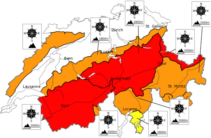

SLF wrote:A very dangerous avalanche situation will be encountered over a wide area
The large amounts of fresh fallen snow and freshly generated snowdrifts in the northern regions and in the Valais have been deposited on top of a loosely-packed snowpack surface and are extremely instable. As a result of the increasing load on the snowpack from the fresh snow, fractures down to more deeply embedded layers of the snowpack can be expected. Due to the marked weak layers inside the old snowpack, fractures can then propagate over great distances.
Thereby, avalanches can be triggered over a large-spread area particularly in starting zones which have not yet discharged and subsequently sweep the entire snowpack along.
The old snowpack is weak in central Valais in particular.
Below approximately 1800 m the snowpack is being weakened by the intensive rainfall, particularly in the northern and the western regions.
On the southern flank of the Alps, the snowpack layering is more favourable. Fractures deeper down inside the snowpack are unlikely.
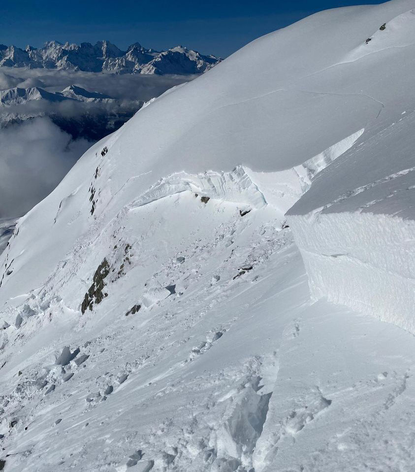
Verbier's tourist office posted the following picture - of an avalanche crown wall - on social media yesterday. You can clearly see the deep but distinct layers in the pack, with the "persistent weak layers" being the obvious boundaries between the deeper slabs.
For the latest bulletin from the Swiss authorities visit www.slf.ch/en/avalanche-bulletin-and-snow-situation.html
France
Meteo France wrote:
Avalanches: Phenomenon occurring on average once every 5 to 10 years for the situation at the end of the night from Thursday to Friday in Savoie and Haute-Savoie, every year in Isère and in the north of the Hautes Alpes.
Very marked rainy episode all the more remarkable as it is accompanied by a warm spell in the mountains, partly at the origin of the avalanche vigilance.
Current situation
RAIN FLOOD:
Sustained precipitation is currently affecting the northern Alps. They still fall in the form of snow at around 800/1000 m at the bottom of inland valleys (Bourg St Maurice and Chamonix) but already in the form of rain further west up to around 1500 m.
Since last night, we have already seen 10 to 20 mm in 12 hours in the form of rain in the lower valleys.
AVALANCHES:
Heavy precipitation accompanied by ongoing warmth settling on a fairly fragile snowpack at altitude in some massifs.
The avalanche risk is currently high (level 4) on all the Haute-Savoie, Savoie and Isère massifs (except Vercors: level 3) as well as in the north of the Hautes Alpes (Thabor, Pelvoux, Champsaur and Dévoluy).
For the latest French bulletin, see vigilance.meteofrance.fr