
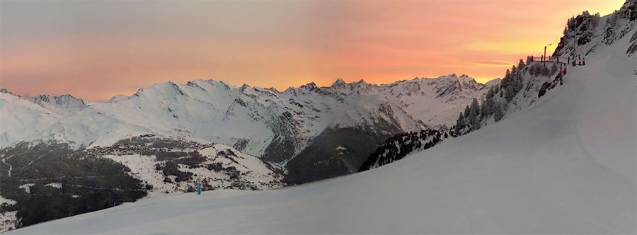
Sunrise at Les Arcs this morning, snow is coming...
Sun then snow for the Alps, and lots of it.
The Snow Headlines - 27th February
- Big snowstorm - potentially biggest of winter so far - rolls into the Alps.
- Riksgransen, Europe's "Spring skiing capital", opens for its 2020 season on Friday.
- Snowfall arriving in the Pyrenees.
- Summer snow in New Zealand at Mt Hutt among other resorts.
- More heavy snowfall in the Rockies.
It's snowing again in the Alps; February has been a snowy month, compared to January, but it's still nearly a fortnight since the last big falls. The snowfall is currently 'mid-storm' so it's not yet clear how much will accumulate, but forecasts are for 30-60cm (1-2 feet) for most areas by Friday.
With meteorological springtime starting Sunday the fresh snow will be good news, particularly after a few 'unseasonably warm' days last weekend.
The good news is that the snow should keep falling into the first week of March, potentially with some of the biggest accumulations of the season so far.
It's been a snowy week in Scandinavia and Scotland, with some of the best conditions of the season so far. There's been fresh snow in Eastern Europe too and the Dolomites and Pyrenees should be seeing some of the best snowfalls for a while.
In North America, most of the continent's ski areas are in good shape. It has kept snowing in the East where the season is now 'normal' after a shaky start and some of the biggest dumps since the weekend have been reported in the Rockies and up in Alaska.
In the Alpine Forecast
A snowy few days, a brief lull and then more snow lining up as March arrives.
French Alps Incoming...
Re-publication :- our Snow Report Summary, being the text above this line, is free to re-publish, but must be clearly credited to www.J2ski.com with text including "J2Ski Snow Report" linked to this page - thank you.
EUROPEAN ALPS
Austria
It was a little too warm over the weekend and at the start of this week in Austria but for most of the country's larger resorts that wasn't a problem.
In the Arlberg, and on the glaciers, the snow is lying more than three metres deep and almost every run is open so a few warm days can't do too much damage.
The good news now though is that we're moving into a period of lower temperatures and fresh snowfall which should last the remainder of this week, with longer-term forecasts suggesting it could continue through next week, meaning some Austrian resorts could receive more than a metre of snow, and most at least half a metre more by this time next week.
France
The snow is falling in the French Alps after a sunny and rather warm weekend on the slopes.
For most areas, the heaviest snowfall is expected on Wednesday-Thursday so we are kind of in the thick of it at the moment, but forecasts are for storm totals to be 30-60cm (12-24 inches) by the time things ease on Friday. So that should be a good start to March on most French slopes.
As it is conditions are, as they have been all season, good at most of the major destination resorts, poor at a few low-lying local ski hills that are making world headlines as evidence of climate change, but aren't really a factor for more recreational skiers.
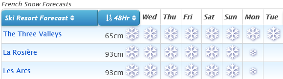
It may be different by the time the snowfall ends but currently La Plagne is posting the deepest snow in the country at 3.2 metres (nearly 11 feet) up top and it reports all but three runs in the Paradiski region it shares with Les Arcs are open.
Italy
Italy rather missed out on some of the big snowfalls of the past month that tracked to the north of its ski areas, with just those along the French and Swiss borders really seeing heavy snowfall.
This time it does look like much of the country is going to see some decent snowfall over the coming week, albeit with the heaviest again along the country's borders, with areas like Cervinia, La Thuile and Aosta Valley resorts in line for potentially a metre of snowfall by Monday.
The Dolomites looks like it too could get a decent fall over the next few days. Only Piedmont in the southwest looks like it should be dry again, ironic that it was there that saw some of the biggest falls of the season in early December.
Switzerland
The snow began falling on Swiss slopes on Tuesday after a very warm weekend (as witnessed by those watching the World Cup races in Crans Montana where temperatures reached double digits above freezing in the base area). Initial totals from the first 24 hours of snowfall were up to 30cm with Andermatt, currently with the deepest base in Europe at 4.5 metres on upper runs, reporting 20cm.
A number of Swiss areas are currently forecast to see more than a metre of snowfall by this time next week, meaning we could see a 5 metre plus base in the Alps by the start of March (last year it was above 6 metres from early January).
Scandinavia
Despite warm weather in central and southern Scandinavia for much of this winter, base depths are pretty good at most of the region's ski areas with everything open outside the warmth-hit areas and the past week has been particularly snowy here.
The deepest snow is over in western Norway where after two months of almost non-stop snowfall it's lying up to 4.3 metres deep, nearing the deepest in Europe. However, the past week has seen 20-50cm snowfalls across most of the entire region.
The famous northern Swedish resort of Riksgransen, up in the Arctic Circle, opens on Friday for its season through to mid-May. The snow depth there ahead of the season start is reported to be the deepest this century.
Pyrenees
It has been another mostly sunny and rather warm week in the Pyrenees but conditions have been changing here too over the past 24 hours or so with snow moving in. As yet it does not look to be as heavy as the forecast for the Alps but skiers in the region will be relieved to see the mercury dropping away and the slopes getting a freshen up about a month after the last snowfall.
Indications currently are for 5-10cm for each of the next two-four days for most areas, bringing potential totals of 20-40cm by the weekend.
Scotland
In most respects, conditions in Scotland have been getting better and better over recent weeks, and March is potentially looking like one of the best months in several years on Scottish slopes.
The weather has been challenging over the past two/three weeks, with many days lost due to gale-force winds, but crucially it has stayed mostly cold and ski areas are building bases, particularly at mid-mountain and above. The forecast for coming few weeks is for temperatures to stay low, more snowfall but probably not as windy as February has been, and without the temperature rises.
Conditions have certainly been the best they've been all season over the past few days. Currently, about 50 of the 120 runs offered by the five Highland ski centres are open, the most there's been at any time for the past few winters. Glencoe is almost fully open, the other four areas generally have half-a-dozen or more runs open.
Eastern Europe
After a rather warm week again in Bulgaria (following some snowfalls at the end of last week) temperatures have plunged below freezing and some snowfall is blowing in Thursday/Friday, expected to bring 20-30cm of fresh snow by the time it passes on by the weekend.
Then it's back to sunshine and warm weather! That shouldn't cause too many problems though as bases look pretty good, the best at Borovets (210-265cm) where everything is open. Less good at Bansko where there's 80cm up top; the track back down to resort has just a few inches of snow on it, but they're reported to be keeping it open every which way they can.
North America
Canada
Quebec and eastern Canada are the main focus for snowfall in Canada at present with a storm expected to bring totals of up to 60cm (two feet) of snow currently in progress. It's the latest sign that winter, even though the season is half over, is finally back to normal in the area that suffered a warm, wet start.
Almost every resort is now fully open.
There was heavy snow earlier this week in the West too, where bases are up above 3 metres (10 feet) at quite a few areas and conditions continue to look nice and powdery. After the heavy snowfall in the east ends late Thursday or early Friday it's looking pretty quiet over the weekend for 'weather' across Canada, with little snow forecast even on the west coast which has been dumped on for much of the past month.
USA
There were some big snowfalls in the Rockies again over the weekend, bringing a foot (30cm) or more snow to resorts in Colorado and Utah and there was more snow too up in Wyoming, Alaska and the Pacific Northwest. It's the east coast that is currently getting dumped on in the latter half of this week though. Like Quebec further north things weren't great in the first weeks and months of the season but are much more 'normal' now and the fresh snow is a bonus here too.
Snowy March! More next week...