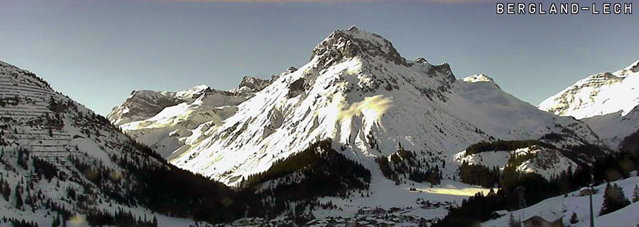
Lech this morning, in the lull before... the snow arrives tomorrow!
Talk of Spring in The Alps was premature; winter's coming back!
This Week's Snow Headlines - 28th February 2019
- Snowfall returns to the Alps with falls in Austria.
- Jackson Hole reports 1m of snowfall in 48 hours on Monday/Tuesday this week.
- World Cup cancelled at Bansko on Saturday due to heavy snow, run on Sunday instead.
- Arizona ski area claims the biggest snowfall in America in the past week. Vegas gets snow too.
- Ski resorts in Austria and Canada announce extended ski seasons.
- Heavy snow in New Zealand three months before 2019 season due to start.
- Heavy snow in British Columbia.
After a warm, sunny February in the Alps conditions are changing back (as we enter Spring) to more wintry weather. Heavy snowfall is expected across the Alps on Friday and then again at the start of next week, so conditions should be well refreshed by the weekend.
The snow is unlikely to reach the Pyrenees however, according to current forecasts, and the Dolomites will have to wait until the second wave next week. Scotland may get some respite as snow is expected here at the weekend and into next week.
Across the Atlantic, it is currently dumping (again) in California, although with storm force winds shutting areas down whilst it goes through. It looks like already-broken February snowfall records will be beaten. There's been plenty of snow again in most other ski regions on the continent too with Jackson hole also expecting to break February snowfall records and some good accumulations on the East Coast.
For novelty snow news this week there's been heavy snowfall in parts of the southern US that rarely see snow including Texas and Las Vegas, with Arizona claiming the biggest snowfall of the previous 7 days in the country up to last weekend.
In addition, several ski areas in the Southern Hemisphere - including Mt Hutt and Mt Dobson in New Zealand - where it's currently summertime, reported a heavy snowfall over the weekend. The ski season starts in the country in June or July but Mt Hutt says they'll open for snow sports this weekend, a fairly unheard of scenario and a particularly ironic one for Scotland in the northern hemisphere where there's not enough snow for centres to properly open there.
In the Alpine Forecast
Although the forecast models are still very uncertain about exact snow quantities and timings, it is clear that temperatures are going cold across a wide area from tomorrow.
An initial band of potentially heavy snow (tomorrow) will affect the northern and eastern Alps in particular, followed by further more widespread snow early next week - which looks set to continue for a while.

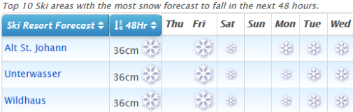
See where it's expected to snow this week...
Re-publication :- our Snow Report Summary, being the text above this line, is free to re-publish, but must be clearly credited to www.J2ski.com with text including "J2Ski Snow Report" linked to this page - thank you.
EUROPEAN ALPS
Austria
It looks like we're heading back into a period of snowy weather in Austria with moderate snowfall forecast across much of the country this Friday and Saturday, and then lighter showers into the start of next week.
However Austria has, unlike the other Alpine 'big 4' nations had some snowfall in the past week too, with ski areas in Upper Austria and Salzburgerland reporting up to 30cm snowfalls at the end of last week, giving a boost to snow depths and (as they are pretty deep anyway), more importantly giving some fresh cover on top.
Six of the 10 deepest snow depths in Austria (which range from 3.5 to 4.5m on upper slopes) are on the country's glaciers with Loser in Salzburgerland, one of the resorts that got a good snowfall in the past week, posting the deepest base of a non-glacier area at 4.5 metres (15 feet).
France
It has been more than a fortnight since the last snowflake fell on French ski slopes but that's about to change with snow forecast across the French Alps from Thursday onwards with the heaviest snow expected on Friday, before conveniently easing off for transfers on Saturdays and Sunday (if forecasts are correct) and coming down heavily again at the start of next week.
Parts of the Chamonix Valley are currently forecast to receive 40-80cm and La Grave over 60cm of new snow. As it is, conditions on French slopes remain fairly placid with warm, sunny days continuing to be the norm, but thanks to accumulated bases, no great problems caused by the thawing so far. The fresh snow on top will certainly be welcome though.
Italy
Regular readers (and/or indeed skiers in Italy) may recall that there were some of the biggest snowfalls of the season across the country at the start on February, but there's been very little since. As with the rest of 'mainland' Europe, it has instead been largely very warm and sunny with great on-piste conditions (if a little too warm and wet by lunchtime), but with no off-piste powder left.
The past week has been much the same but here too there is now snow in the forecast. Only really lights now on Friday compared to Austria, Switzerland and France although resorts in the Northwest around the Aosta Valley should get 30cm or so, then, although it is still a little far off to be certain, it looks like bigger snowfalls on Monday/Tuesday next week with the Dolomites getting a decent dump too that time.
Switzerland
As with much of the rest of the European Alpine region, snow is expected to start falling on Switzerland from Thursday onwards with snowfalls of up to 50cm possible by this time next week at some resorts, although it may be more like 10-20cm at others. Currently, the heaviest snowfall is initially expected to be in the west and centre of the country with the 4 Valleys and Gstaad region among those expecting bigger accumulations.
Andermatt, which continues to post the world's deepest base this season at 6m/20 feet, is set to receive a 50cm top up. It, like other Swiss areas, has had warm, sunny weather for much of the past few weeks so the snow will be welcome here too.
Scandinavia
Most snowfall in Europe at the start of this week was falling in Sweden and Norway as again this region manages to keep the snow falling whilst most of Europe doesn't. Alas, that has not been the case in Finland though, which is reporting its warmest winter for 30 years.
Riksgransen up in the Arctic Circle in Northern Sweden, where you can ski under the midnight sun in May, opens for its unusual ski season, which always runs through meteorological spring on Friday, 1st March.
Pyrenees
Andorra and the Pyrenees have had another snowless week and a particularly warm one with temperatures in Soldeu reaching 15C in the resort and even at the top of the mountain not getting below 5C some days. So there's some thawing but fortunately not enough to make a major impact on the base depths.
Unlike the Alps, there's currently not any significant snowfall in the forecast either, although there are increasingly promising signs of some snowfall around Tuesday/Wednesday next week, perhaps 10-20cm.
Scotland
It's been another week of record-breaking February temperatures in Scotland with more of the remaining high
altitude snow patches shrinking and the hillsides now almost entirely green and brown. There's some signs of colder weather and a few centimetres of snow at last at the weekend, then a more wintry picture next week as we move into spring (you know it makes sense), but it doesn't yet look like enough for areas to reopen.
In the meantime, the purchase of all-weather snow-making machines by The Lecht, Glencoe and Cairngorm which are continuing to churn out snow for beginner slopes seem an ever wiser investment. Nevis Range is now talking about a similar purchase too.
Eastern Europe
There was the first fresh snow for several weeks in various parts of eastern Europe over the weekend.
Bulgaria got particularly heavy snowfall with World Cup racing cancelled on Saturday in Bulgaria and 30cm of fresh snow reported for Bansko. There was also fresh snow in parts of the Czech and Slovak Republic as the snow fell in Austria to the south.
North America
Canada
It has been a fairly snowy week in Canada, again, with the biggest snowfalls reported last weekend in Eastern BC, with both Big White and Fernie reporting more than 40cm of snowfall within a 24 hour period, resulting in deep powder joy.
Fernie overtook Whistler to report the deepest base in Western Canada of the country's big-name resorts, although whistler has now gone back on top despite seeming to report less actual snowfall this week.
Tremblant in the East continues to have the country's deepest base at over 4.5 metres. The coming weeks looks like mores now across the country though perhaps a little less than the past seven days with the biggest overall accumulations currently looking like 20-30cm for the start of spring.
USA
There have been more massive snowstorms in Western North America over the past few days as more resorts in the region report February 2019 their snowiest February ever.
The latest heavy snow – with resorts reporting up to (another) 1,4 metres (nearly five feet) in 72 hours has again been driven in on strong gale force winds for full blizzard conditions meaning the practicalities of opening centre can be challenging and at resorts like Diamond Peak which have an on-going power failure, impossible.
Plenty of snow a little inland from the Pacific coast too with resorts in Arizona and New Mexico reporting big snowfalls and Jackson Hole to the north clocking up over a metre of snowfall in 48 hours earlier this week – it's another reporting record February snow. There's been snow in the East too, although more like 20-40cm accumulations and here too accompanied by very strong winds at times.
Until next week... enjoy!