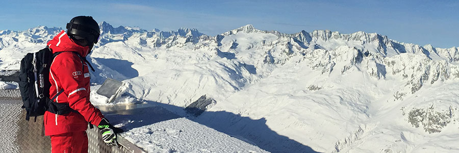
Much snow, all over everywhere, Andermatt, Switzerland, surveyed by local guide (and ace accordionist!) Fränggi Gehrig
Some massive snowfall, followed by clearing weather in The Alps this week.
This Week's Snow Headlines - 17th January 2019
- Base depths pass 5, then 6 metres at Andermatt, Swiss Alps (deepest in the world at present)
- Avalanche danger at maximum (level 5) for a time in parts of Austria, Switzerland.
- First big snowstorms for almost a month in Western Alps.
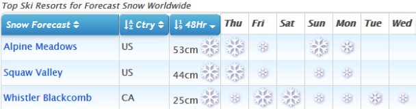
- Whistler reports that despite the slow start it got the most December snowfall in its history.
- Turning colder in Scotland at last, but more snow needed for full runs to open.
- (Possibly) One of biggest blizzards of past decades due to hit California.
- Fresh snow in the Pyrenees.
It's been another week of spectacular snowfall stats for parts of Europe.
The Eastern Alps have continued to see the biggest snowfalls in Europe with a story in The Times claiming that some areas saw 3 metres (10 feet) of snowfall in 48 hours, which they're reporting as "the most for a century" although the most we've seen at J2Ski in terms of ski resort accumulation have been still astronomical amounts of 1 metre (3.3 feet) in 24 hours, 2.1m (7 feet) in 72 hours and 3.3m (11 feet) in a week.
The latest snow comes on top of similar accumulations over the previous three weeks meaning that resort and transport infrastructure continues to struggle; with airports, roads, rail lines and ski slopes closed for periods in places. The vast majority of ski areas are open, however, with the situation improving as the weather clears.
The newly linked Andermatt-Sedrun-Disentis area posted the first 5m base depth in the world for its upper slopes last week and then a 6 metre (20 foot) depth on Tuesday, whilst Austrian resort Loser hit 5.1m (17 feet) for its upper slope snow depth.
After a dry month the promised snow arrived in the Western Alps on Wednesday/Thursday last week with a second snowstorm at its peak on Sunday/Monday. The resulting accumulations were over 50cm of fresh snow for many, and almost a metre for some, so conditions were transformed with the fresh cover.
Elsewhere in Europe it has been snowy in the East with conditions great in most countries and there's also been some fresh snow in the Dolomites. The Pyrenees also got a little new snow after a dry month but are yet to see a major snowstorm (unless we count the unusual ones back in late October and early November).
In Scandinavia there have been some moderate falls in parts of Norway and smaller accumulations in Sweden. Scotland is yet to open any full length runs as the slopes remain just 'dusted' with snow but it is getting colder so hopefully this will change before the end of the month.
Across the Atlantic it has been a fairly quiet week with conditions turning colder on the East coast and some fresh snow. There's been more snow on the West too but not so much as the previous week. However what looks like another big snowstorm is just getting underway in California.
In the Alpine Forecast
Snowfall does look like easing for the Alps over the next week, with temperatures - after a mild day or two - staying below seasonal averages. Mostly light, scattered snowfall will continue but there don't look to be any more huge snowfalls imminent.

See where it's expected to snow this week...
Re-publication :- our Snow Report Summary, being the text above this line, is free to re-publish, but must be clearly credited to www.J2ski.com with text including "J2Ski Snow Report" linked to this page - thank you.
EUROPEAN ALPS
Austria
It has been another remarkable week for snowfall in Northern and Western Austria with base depths now past the 5 metres mark at Loser ski area in Styria and at 4 metres plus at a host of big name ski areas including Solden and St Anton.
As has been widely reported, the snowfall has been causing problems both on and off the slopes with high avalanche danger and a number of smaller ski areas as well as some glaciers remain closed for the time being whilst the ski areas are made accessible and safe.
However the vast majority do continue to function and have a sizeable chunk of their terrain open, with that amount likely to grow quickly now as conditions ease. Solden reports 100km of its 140km of runs open for example, although in the Arlberg it's more like 40% at present that's open – 140km of 305km there.
France
It has been looking increasingly wintery in France over the past week with the long-awaited return of snowfall to the French Alps last Wednesday/Thursday and then a heavier band of snow moving in on Sunday/Monday bringing more than 50cm of fresh snow to some resorts and a good healthy fall (20-40cm) to most others.
A number of ski areas including Val d'Isere, La Rosiere, Tignes, Bonneval sur Arc and Sainte Foy have all moved beyond 2 metre upper base depths as a result for the first time this season. The forecast is for more of the same, a few sunny days followed by a few snowy ones, which should keep improving things nicely.
Italy
It has been the snowiest week for some time in Italy with ski areas across the country receiving at least some fresh snow to freshen up their slopes. Some of the biggest falls were reported in the Lombardy region at the start of the week with Bormio posting a 30cm accumulation in 24 hours and Livigno 32cm but over in the Dolomites there was 10-20cm of fresh snow on slopes that haven't seen any natural snowfall for more than a month - and there was snow for the West too along the French and Swiss borders, where Cervinia got 60cm (two feet) of new snow from the storm, improving conditions almost everywhere.
Switzerland
A very snowy week in Switzerland which saw the snowfall spread to the centre and west of the country with some sizeable snowfalls on Wednesday/Thursday last week and then again on Saturday-Monday. The heaviest snowfall was on Sunday when many resorts reported 30-40cm and Zermatt a full 70cm in 24 hours.
The East of the country still got the biggest snowfalls though with Arosa reporting 1.8 metres (6 feet) of snow in the past week but conditions are easing now and roads and slopes opening.
Scandinavia
More of the same really in Scandinavia with some snowfall reported, most of it in Norway with 20-40cm reported in the past week. Bases across the region are typically in the 30-60cm bracket which is fairly normal for this early in the season and means that most areas have most of their runs open.
Pyrenees
Some improvement in the Pyrenees where there's been very little snow since the big snowfalls started the season early back in late October and November. The French Pyrenees saw the biggest falls in the region last week with some reporting up to 30cm of fresh snow, dramatically improving conditions there. In Andorra the numbers were closer to 10cm but still very welcome. Vallnord (40/70cm) has the deepest snow base and most of its terrain open. More snow is forecast next weekend.
Scotland
Scotland's ski season is yet to properly start after the mostly warm and dry end of Autumn and start to winter in the highlands. However the past week has seen more promising signs with some modest snowfalls on the hills, probably not yet enough to open much but a step in the right direction.
Three centres are continuing to offer beginner lessons on small snow areas created with their new TechnoAlpin all-weather snow-making machines – Cairngorm, Glencoe and The Lecht. Cairngorm in particular has been opening a bigger area with temperatures low enough for it to run its new conventional snow-making too in the past few days.
Eastern Europe
Parts of Eastern Europe continued to see some of the big Eastern Alps/Tatras snowfalls over the weekend with Slovakian ski areas seeing another 20-40cm. Vrátna Malá Fatra (50/140cm) has the country's deepest base but unlike in Austria and Germany there haven't been many issues keeping access and slopes open.
There was less fresh snow in Poland to the north where the famous Kasprowy Wierch (57/221cm) at Zakopane has the deepest base. Bulgaria's ski areas are looking much better than they did at the start of the year thanks to ongoing snowfalls.
North America
Canada
The huge snowfalls that have been dumping deep powder on Canada's West Coast have taken a bit of a break over the past week although there are now signs of the snowfall returning over the next few days.
Whistler, which recently reported that it got more snow in December than it had received in any previous December, is reporting the country's deepest base at nearly 2.7 metres (9 feet) but snow cover is good across most of Alberta and BC. Parts of Quebec had previously reported unseasonably warm temperatures but that now appears to be a thing of the past with colder weather and some fresh snow here too.
USA
As with Canada the West Coast has seen a bit of a break from the snowy onslaught over the past month, particularly in the Northwest corner of the country. The deepest bases in the US, at over 3 metres (10 feet), are still there but the little snow that has fallen over the past week has largely been further south in New Mexico and southern California.
The snowfall is now returning across a wide area of the West however and is set to intensify through Thursday, although California (where there may be as much as a metre of snow from the latest storm by the weekend, as well as winds reaching 100mph according to some forecast creating the potential for a serious blizzard) and Utah (more like 30cm/a foot) look set to see more snow than Colorado to the south.
On the East Coast temperatures have dropped back to nearer normal and there has been some fresh snow too, greatly improving conditions in the region.