It's deep, and it's snowing again, in Les Arcs this morning...
J2Ski Snow Report 15th February 2018
Snow's back all over the place, with more to come...
This Week's Snow Headlines
- More snow for Colorado; conditions improving at most areas in the ski state.
- World's deepest snowbase moves back above 6m/20 feet mark.
- Scotland continues to enjoy best season for several years.
- Up to 60cm (2 feet) of snow expected in Western Alps by Saturday.
It's been an oddly mixed week of sunshine and snow showers in many parts of the ski world, and the coming week is looking similar again. After mostly sunny weather there was snow in much of the Alps, although light in most areas.
Some resorts, in Switzerland, the extreme west of France and East of Austria did report up to 60cm of snowfall. Parts of the Pyrenees, particularly the French side, reported bigger snowfalls, up to about a metre at the weekend. Elsewhere in Europe there was heavy snow in Western Norway and more snow in Scotland, where their good continues - albeit punctuated, inevitably, by stormy days.
Over in North America; Alberta and BC in Canada have seen some big snowfalls, with up to 90cm of snow and Lake Louise excitedly proclaiming their best conditions in 20 years. Parts of the drought-struck US West have seen good snowfalls too, particularly Colorado which is now almost fully open.
The Olympic venues in South Korea continue to be very cold and with problematic winds at times. The winds are expected to ease for the remainder of the Games so the postponed events from the first five days can go ahead.
In the Alpine Forecast
Northern French Alps, Swiss Alps and parts of Austria and Italy should see some good falls of snow over the next 48 hours, with ligher snows following through the weekend.
Accumulations could exceed 50cm in some locations although totals of 15-20cm will be more widespread. Clearer weather should follow as we move into next week, with scattered snow showers to the East.
The long range forecasts are starting to indicate colder conditions for the end of the month, and we'll have more on that next week.

See when and where it's going to snow...
Re-publication :- our Snow Report Summary, being the text above this line, is free to re-publish, but must be clearly credited to www.J2ski.com with text including "J2Ski Snow Report" linked to this page - thank you.
EUROPEAN ALPS
Austria
It has turned snowy this week in Austria with some significant snowfalls over last weekend and at the start of this week in many areas, particularly in the West of the country, and after a few clear days, more snow is forecast for the rest of this week, particularly in the north and west where up to 40cm is expected in the Arlberg region.
Otherwise snow depths remain good across Austria with almost all the country's ski area's fully open. The glaciers have the deepest bases at up to a remarkable 575cm (19 feet) depth on the Kauntertal glacier, close to the world's deepest, but many non-glacier resorts have 3-4m depths too so it should be a great second half to the season.
France
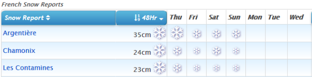
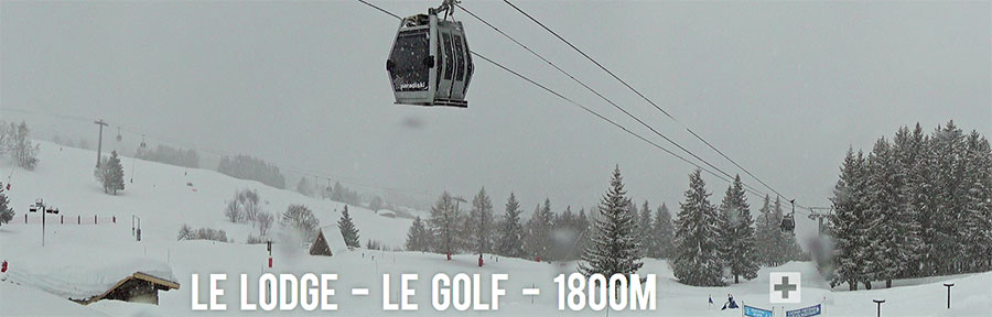
It's been quite a mixed week for snowfall in France, and it looks like the week ahead will be much the same. The biggest falls reported were in the French Pyrenees for a second week where one resort had to close at the start of the busy February half term holiday period as the snow blocked roads and closed lifts. There was also snow in the French Alps, the heaviest in border areas like the Grand Massif and Portes du Soleil which reported 20-30cm of fresh snow on Sunday/Monday.
The rest of this week should see biggest snowfalls in the Alps with Chamonix currently forecast to receive more than 60cm (two feet) of snow by the end of Friday. In between the snowfall and snowy regions though the skies are clear and base depths remain exceptionally good.
Italy
Italian resorts seemed to largely miss out on the snowfall at the weekend, with much of it passing to the north, although some centres did catch a few centimetres. They'll catch a little more snow over the coming few days when the next wave is due to pass east, for example 10-15cm for Cervinia but otherwise largely sunny conditions, which is what many Italian skiers prioritise over powder we're reliably informed, so they should be happy. Thanks to all the snow that did fall in the autumn and first half of winter bases are good across Italy too, so again most centres are fully open. Cervinia has the deepest base of the country's major resorts at just over 4 metres.
Switzerland
Swiss resorts seemed to get the best of the fresh snow over the weekend with resorts there reporting up to 60cm (two feet) of new cover and a number of Swiss areas posting powder alarms for 20cm or more fresh snow in 24 hours. Amongst them Engelberg, which had previously posted an upper base depth of 645cm after the big January snowfalls. That number had slid to 595cm last week after a fairly dry three weeks but has now gone back over six metres (2 feet) following its 36cm snowfall on Sunday/Monday.
As with the other big four Alpine nations, conditions at almost all Swiss ski centres are good, base depths excellent and there's more snow expected in many parts of the country over the next few days.
Scotland
It's been a bit wild and windy at times on Scottish ski slopes over the past few days. Yesterday Glenshee was closed as the snow gates were shut across the main north-south road that passes by it and other centres were stormbound. But other days have been clear and still and the good news is that temperatures have stayed low so that for the first time all five Highland centres have at least half of their lifts and runs open and snow depths are building.
Pyrenees
It has been a snowy fortnight in the Pyrenees with wave after wave of snow storms bringing 20-30cm of fresh snow every few days to the region. The French side is posting the biggest accumulation numbers with bases now up towards 2.9m (10 feet) and at least one centre (Porte Puymorens) forced to close on Saturday after it got over a metre of snow in a week. But resorts in Andorra and Spain too have gleefully been posting images and videos of visiting skiers and boarders cruising through deep powder. There's still more snowfall in the forecast too.
Scandinavia
Norway continues to report a snowy winter with still more good snowfalls on the west bringing repeat powder conditions to resorts like Voss and base depths up to 3.8m at Roldal. The coming week looks similar here. Conditions are fairly good in Finland and Sweden too although more southerly centres have had too much warm weather and cover is limited.
Eastern Europe
5-20cm of fresh snow has been reported in Bulgaria since the weekend when all of the resorts are saying they're fully open except Pamporovo which has about half of its pistes skiable and a reported base depth of 20-120cm. Elsewhere in the East conditions are largely good with more fresh snow forecast in Slovenia and the Czech Republic amongst other countries in the region over the next few days.
North America
Canada
A snowy week in Western Canada where base depths are in the 2.5 – 3.2m range at many of the well-known resorts in the region following 40-90cm more snow over the past week. Revelstoke was particularly delighted by their foot of fresh powder on Tuesday whilst Lake Louise is claiming conditions are as good as they've been at any time over the past 20 years.
The coming week is looking much the same with heavy snowfall days alternating with sunny days as each front moves in then continues on. Not much fresh snow in the East of Canada this week but bases have improved a good deal following sow earlier in the month and most of the major centres in Quebec are fully open.
USA
Colorado's resorts have reported up to 90cm of fresh snowfall this week which has continued to improve conditions so that most of the state's resorts are fully open, or almost so. It's a similar picture in Utah to the north.
It's still not a great season in many areas of the US West though. California's areas are still struggling for decent cover with some small areas in the south of the state yet to open. Others in states including Idaho, Arizona and New Mexico have not opened or hardly opened all season. Actually the same is true in the continent's opposite corner – up in New Brunswick, Eastern Canada, where the small ski areas have also had little snow. No fresh snow in the East of the country this week but most areas still have good bases built up through December and January so have most of their terrain open.